An official website of the United States government
Here's how you know
Official websites use .gov A
.gov website belongs to an official government
organization in the United States.
Secure .gov websites use HTTPS A
lock (
) or https:// means you've safely connected to
the .gov website. Share sensitive information only on official,
secure websites.
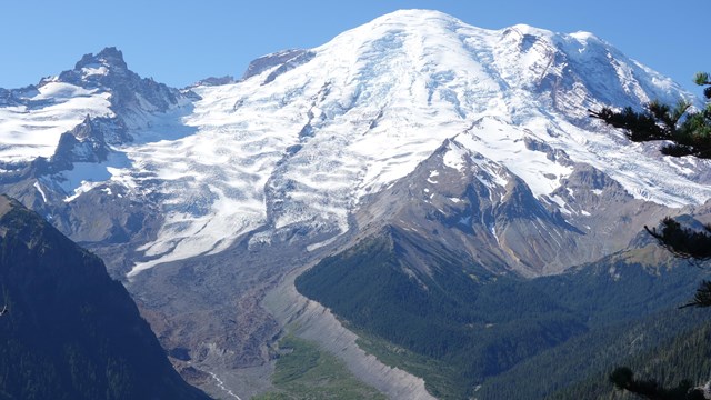
Mount Rainier, rising to 14,410 feet and surrounded by a dramatic landscape of volcanic ridges and glacier-carved valleys, is an icon on the horizon in the Pacific Northwest. Look closer, and this familiar landscape contains the origin story of this area. It has been covered in swamps and ancient seas, flowing lava, explosive ash, and thick sheets of ice. Mountains rose and eroded away. The features described on this webpage provide an outline of Mount Rainier’s geologic past, but it does not cover every formation you may observe while exploring the park.
This map highlights some of the geologic formations found in Mount Rainier National Park found in different time periods. For the best viewing experience, click on "View full screen" in the lower left corner.
Formed over the last 500,000 years, modern Mount Rainier is a relatively young volcano standing on a foundation of rocks millions of years old. Some of these pre-Mount Rainier formations include:
Puget Group rock formation along Mowich Lake Road (SR165), just outside the border of the park.
NPS Photo
Puget Group, 40+ million years ago
Over 40 million years ago, lowland swamps left behind layers of sandstone, shale, and coal. This coal was later mined near the Carbon River area, outside the northwest corner of the park.
Ohanapecosh Formation (darker grey rocks) along SR410.
NPS Photo
Ohanapecosh Formation, 36-28 million years ago
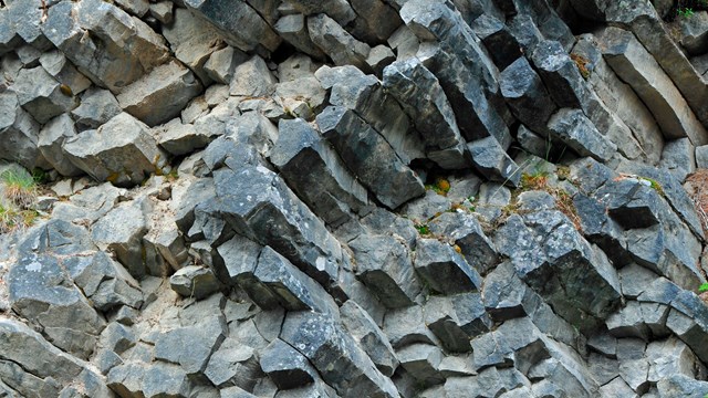
Ancient Ohanapecosh Formation volcanoes erupted underwater, forming layers sandstone and breccia that have been compressed and folded over millions of years. These layers are visible between Cayuse Pass and Tipsoo Lake along State Route 410.
Stevens Ridge Formation cliffs along Stevens Canyon Road.
NPS Photo
Stevens Ridge Formation, 26 million years ago
Early volcanoes erupted pumice and welded tuff. Visible in cliffs west of Box Canyon along Stevens Canyon Road.
Tatoosh Granodiorite rocks along the White River Road.
NPS Photo
Tatoosh Granodiorite, 18-14 million years ago
A large mass of molten rock slowly cooled under the surface, forming granodiorite, a rock similar to granite. This granodiorite underlies the Tatoosh Range, White River, Carbon River, and Nisqually River Valleys. View it up-close along White River Road near the White River Campground.
Mount Adams, and distant Mount Hood, rise above the mountain peaks and ridges of the Cascade Range, as viewed looking south from Panhandle Gap on the east side of Mount Rainier.
NPS Photo
The Cascade Range
The Cascade Range starts to rise through subduction uplifting 10 million years ago, completing the geologic foundation of the Mount Rainier.
Formation of Mount Rainier
A subduction zone is an area where one tectonic plate is being forced underneath another into the earth's mantle. Approximately 50 miles down, chemical changes lower the melting point of rock, causing the subducting slab to partially melt, creating magma. Some magma bubbles to the surface of the earth and erupts out of volcanoes as lava. An ancestral volcano stood in the same place as modern Mount Rainier from 1-2 million years ago. It largely eroded during a period of low volcanic activity before modern Mount Rainier started to rebuild.
Modern Mount Rainier was built by numerous eruptions over the last 500,000 years, alternating between periods of high volume and low volume eruptions. These eruptions built up layer after layer of lava and loose rubble, eventually forming the tall cone that characterizes composite volcanoes. Some of these eruptions produced notable features on Mount Rainier that are still visible today.
Burroughs Mountain, the rocky, rounded formation in front of Mount Rainier, as viewed along the Sourdough Ridge Trail at Sunrise.
NPS Photo
Burroughs Mountain, 500-420 thousand years ago
Built during a very active eruptive period and some of the oldest lava flows in the park. Visible from the Sunrise Area.
Rampart Ridge viewed from the Longmire Area.
NPS Photo
Rampart Ridge, 380 thousand years ago
Began as a lava flow that formed against a wall of glacier ice, creating the steep lava cliffs visible from Longmire today.
Little Tahoma viewed from the Sunrise Area.
NPS Photo
Little Tahoma Peak, 160-40 thousand years ago
Formed from dikes and vents feeding lava to the side of Mount Rainier, instead of erupting from the summit. This prominent feature on Mount Rainier's eastern slopes can be viewed from many locations in the park.
Gibralter Rock, a distinctive flat-topped rock feature on the upper mountain, as viewed from the Nisqually Vista Trail at Paradise.
NPS Photo
Gibraltar Rock, 40-14 thousand years ago
Rocks of many ages are exposed in the upper mountain features of Liberty Ridge, Willis Wall, Success Cleaver, and Gibraltar Rock.
Lava ridges breaking through the Emmons Glacier, viewed from the Emmons Vista Overlooks at Sunrise.
NPS Photo
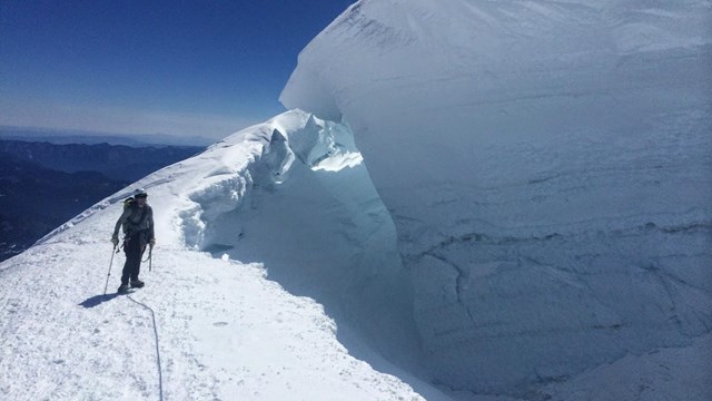
Emmons Glacier Lava Flows, 2.2 thousand years ago
Mount Rainier’s youngest features are the summit craters built around 1,000 years ago, and small surface lava flows under the Emmons and Winthrop Glaciers. Edges of these lava flows are visible breaking through the Emmons Glacier.
A portion of an exhibit at the Sunrise Visitor Center showing different layers of ash found at Mount Rainier. Layer 4 is ash from the Summerland Series, a combination of six ash and tephra layers from Mount Rainier eruptions 2,200-2,700 years ago.
NPS Photo
Volcanic Ash
Mount Rainier has erupted numerous times. Ash, both from Mount Rainier and neighboring volcanoes like Mount St. Helens, created layers interspersed by rocks from debris flows and glaciers. These strata layers visible throughout the park and are a detailed timeline of Mount Rainier’s relatively recent past.
Mount Rainier, an icon of the Pacific Northwest, is surrounded by a dramatic landscape of volcanic ridges and glacier-carved valleys. Look closer, and this familiar landscape contains the origin story of this area. It has been covered in swamps and ancient seas, flowing lava, explosive ash, and thick sheets of ice. Mountains rose and eroded away.