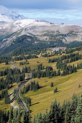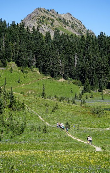
NPS Photo At an elevation of 6,400 feet, Sunrise is the highest point that can be reached by vehicle at Mount Rainier National Park. In summer, mountain meadows abound with wildflowers. On clear summer days, Sunrise provides breathtaking views of Mount Rainier and Emmons Glacier. Sunrise Point offers nearly 360-degree views of the surrounding valleys, Mount Rainier, and other volcanoes in the Cascade Range such as Mount Adams. These views and an excellent trail system make Sunrise the second most visited location in the park. Sunrise is located 60 miles northeast of the Nisqually Entrance and 14 miles northwest of the Sunrise/White River turnoff on State Route 410. The article, White River and Sunrise: The Captivating Northeast Corner of Mount Rainier National Park, provides an overview of the history of the area. The Sunrise Road usually opens in late June or early July and closes in late September to early October. Check the road status before setting out. 
NPS Photo ServicesSee Operating Hours and Seasons for current information about these facilities. The Sunrise Day Lodge is open from early July to late September, offers food service and a gift shop. There is no overnight lodging at the Sunrise Day Lodge. CampingThe White River Campground and picnic area is located 5.2 miles from the White River Entrance and 12 miles from the Sunrise Visitor Center. 
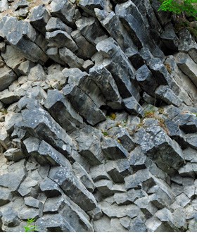
NPS Photo Roadside AttractionsTipsoo Lake - Located at Chinook Pass, this subalpine lake is set in a glacier-carved basin amid spectacular wildflower meadows. White River Patrol Cabin - Located in White River Campground Loop C, this historic patrol cabin was built in the late 1920s and is part of a series of patrol cabins linked by trails that helped the early rangers protect the park. Columnar Lava - On the drive from White River Campground to Sunrise Point, watch the left-hand road banks for andesite columns that formed from an ancient Mount Rainier lava flow. This lava formation is one of the stops in the Sunrise Geology Audio Tour, also available in the NPS App. Sunrise Point - Sweeping views of the Cascade Range to the east, Sunrise Lake to the north, and Mount Rainier to the southwest. Sunrise - The fortress and blockade style structures of the Sunrise Visitor Center as well as the rustic Sunrise Day Lodge are part of the National Historic Landmark District. They are set amid colorful subalpine meadows with Emmons Glacier and Mount Rainier as a stunning backdrop. Yakima Park - The meadows surrounding Sunrise are known collectively as Yakima Park. During the summers, this area was a favorite of the Yakama people for hunting and gathering. For thousands of years, these and other subalpine meadows have been important to indigenous people for their beauty and for the valuable plant and animal resources they provide. Learn more about the geology of the area by listening to the Sunrise Geology Audio Tour while driving along the Sunrise Road! This audio tour also takes you on a short walk to explore the glaciers and moraines visible from the Emmons Glacier Overlooks.
NPS Photo HikingAlong State Route 410:Tipsoo Lake (0.5 mi/0.8 km) Crystal Lakes Trail (6.3 mi/10.1 km) Naches Peak Loop Trail (3.4 mi/5.5 km) At White River:Summerland Trail (8.5 mi/13.7 km) Glacier Basin Trail (6.5 mi/10.5 km) At Sunrise Point:Palisades Lake Trail (7 mi/11.3 km) At Sunrise:Sunrise Nature Trail (1.5 mi/2.4 km) Emmons Vista Overlooks (1 mi/1.6 km) Frozen Lake Loop Trail (3 mi/4.8 km) Silver Forest Trail (2 mi/3.2 km) Shadow Lake Loop (3 mi/4.8km) Mount Fremont Lookout Trail (5.6 mi/9.0 km) Burroughs Mountain Trail (First Burroughs: 4.7 mi/7.5 km, Second Burroughs: 7 mi/11.2 km) Enjoy further day hikes in the Sunrise area, or learn about more Trails of Mount Rainier.
Visit our keyboard shortcuts docs for details
There are many ways to experience Mount Rainier National Park. Explore the wide variety of terrain in the Sunrise area through this video. Hike through subalpine meadows up to alpine tundra. Play next to glacier-fed rivers, watch wildlife, and camp in the wilderness. |
Last updated: December 5, 2025
