Spring Snow Clearing

 
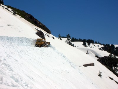
A yellow snowplow clears snow backed by a snow-covered mountain
Every year, Lassen must plow up to 40 feet of snow from its park highway.

NPS photo

Highway 89 through Lassen Volcanic National Park is known as the official park highway. This 30-mile stretch traverses avalanche-prone slopes with up to 2,000 foot drops and can hold a snowpack up to 40 feet deep. The road closes due to snow in the fall. Snow clearing operations usually begin as early as late March and continues for about two months before the highway is entirely open.

Once a section of road is cleared, it remains closed to vehicles until the last layer of snow and ice melts and all road preparations (e.g. signs, shoulder grading, parking areas) are complete. Visitors can hike or bike any cleared section of the road before it opens to vehicles.

Current Road Status

Current road closures are posted as alerts to the top of every page. If there is no active closure alert, then the park road is fully open. All alerts are also listed on our Alerts & Conditions page.
Annual Road Clearing Operator Log


A bulldozer pushes deep snow off a slope below Emerald Lake on the park highway.
A bulldozer pushes snow off a steep slope below Emerald Lake on the park highway.

NPS photo

Order of Operations

Road crews begin clearing snow from the park highway in March or April, depending on snow depth and weather forecasts, and follow this order of operations:

  1. Manzanita Lake Area between Loomis Plaza and Devastated Area (10 miles).
  2. Southwest Area between Kohm Yah-mah-nee Visitor Center and Lassen Peak (8 miles).
  3. Devastated Area to Lassen Peak (12 miles).

Delays and other Considerations

Clearing the park highway is no quick or easy undertaking! Snow depth can reach up to 30 feet at the highest elevations, with drifts occasionally reach as high as 40 feet. Spring clearing schedules and opening dates vary from year to year and cannot be predicted. The factors involved in this time-consuming annual process include:

  • Heavy snowpack with deeper snowdrifts in some areas
  • Trees and boulders that have fallen across the road and been buried in the snow
  • Rockslides over the highway when the snow begins to melt
  • Snow avalanches over cleared sections of the highway
  • Snow storms (and additional accumulation) during the operations
  • Snow removal in parking areas
  • Road and road shoulder repairs
  • Lingering ice once snow is cleared
  • Equipment repair
 

Road Opening and Closing Dates, 1980 to Present

* Closing date refers to date the park highway officially closed for the year. The road may temporarily close earlier for lighter snowfalls.

Historic opening and closing dates for Lassen Volcanic National Park's highway.

Year

Date plowing began from southwest

Date road opened

April 1 Snow Depth at Lake Helen (8,200' elevation)

Date road closed

1980 April 20 May 29 231" / 19.3' November 21
1981 April 20 May 21 149" / 12.5' November 3
1982 April 19 June 18 266" / 22.2' October 25
1983 April 18 July 2 331" / 27.6' November 10
1984 April 23 June 4 175" / 14.6' October 28
1985 April 14 May 18 163" / 13.6' October 21
1986 April 7 June 7 195" / 16.3' November 24
1987 April 20 May 15 138" / 11.6' November 13
1988 April 2 May 20 98" / 8.2' November 7
1989 April 3 June 6 223" / 18.6' October 23
1990 April 1 April 28 106" / 8.9' November 14
1991 April 7 May 24 151" / 12.6' October 22
1992 April 6 May 14 127" / 10.6' October 29
1993 April 12 June 28 225" / 18.8' November 10
1994 April 3 May 20 101" / 8.4' November 7
1995 March 19 July 21 287" / 23.9' November 21
1996 April 1 June 12 171" / 14.3' October 18
1997 April 7 June 5 135" / 11.3' November 14
1998 April 5 July 12 250" / 20.9' November 10
1999 April 12 June 11 194" / 16.2' November 19
2000 April 3 June 2 178" / 14.9' November 17
2001 April 2 May 10 109" / 9.1' November 15
2002 April 1 May 22 166" / 13.9' November 13
2003 March 26 May 23 185" / 15.5' November 7
2004 March 11 May 27 187" / 15.6' October 28
2005 April 4 June 2 173" / 14.5' November 8
2006 April 3 July 6 266" / 22.2' November 11
2007 April 2 May 18 112" / 9.3' December 6
2008 March 31 May 18 132" / 11' December 12
2009 April 13 June 4 146" / 12.2' November 18
2010 April 19 July 8 169" / 14.1' October 23
2011 April 19 July 16 242" / 20.2' November 22
2012 April 21 June 1 145" / 12.1' November 19
2013 March 21 May 24 140" / 11.7' December 18
2014 April 3 May 19 122" / 10.2' December 1
2015 March 31 May 3 91" / 7.6' November 8
2016 April 18 June 12 199" / 16.6' October 30
2017 April 4 July 26 243" / 20.3' November 10
2018 March 30 May 27 131" / 11' November 20
2019 April 18 June 22 238" / 19.8' November 29
2020 March 19 May 29 119" / 10' November 13
2021 April 5 May 17 114.5" / 9.5' October 21
2022 March 16 June 3 96" / 8' November 6
2023 May 15 July 1 217"/ 18' December 5
2024 April 30 June 20 193"/16'


Outlying Park Areas

The park may also plow snow from Butte Lake, Warner Valley, or Juniper Lake roads, depending on the spring snow depth. The paved sections of Warner Valley and Juniper Lake roads are maintained by Plumas County and are usually not plowed.


Relevant Information

 
semi-arial view of mountain ridgelines
Park Map

Explore the digital park map, including facilities, trails, and features.
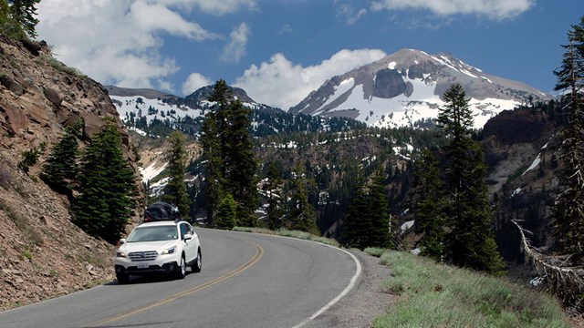
A white vehicle on a highway backed by a snow-covered volcano
Directions & Getting Around

Get directions to the park, navigating through the park, and driving around the park when the road closes in winter.

wetland area with tall pine trees and gray cloudy skies above
Weather

Find specific forecast information for different parts of the park and related links.

A man stands on a snowplow flanked by walls of snow
Snowpack

Why is Lassen's snowpack important, how is it measured, and why?

A color landscape of dark green conifers with snow on the ground and on top of background peaks
Webcams

See what the park currently looks like though continuously updating webcams.

Sledders enjoing the snowy slopes near the Kohm Yah-mah-nee Visitor Center
Visiting in Winter

Winter is a season of snow and solitude. Vehicle access is limited, but over-the-snow adventure is seemingly endless.

cross-country skiers on a snow-covered mountainside, blue sky behind
Oversnow Route Conditions

November to May, learn about conditions on oversnow routes in the park.

Two adults and two children on two extendable bicycles on a highway with snow in the background
Hike and Bike the Highway

During spring snow clearing operations, the park road opens to hiking and biking before it opens to vehicles.


Last updated: September 17, 2024

Park footer

Contact Info

Mailing Address:

PO Box 100
Mineral, CA 96063

Phone:

530 595-4480

Contact Us