
Traditionally, the Kootenai referred to Glacier National Park as Ya·qawiswit̓xuki, meaning "the place where there is a lot of ice."Glacier National Park's glaciers support the American way of life by contributing meltwater to irrigation for agriculture, to cold streams for wildlife, and to lakes for recreation. The melting of the park's glaciers does have consequences, but for many people glacier retreat itself has become enough reason for concern. The national park was named for its many active glaciers. Losing these glaciers may be a lesson about the significance of the crisis. Though other effects of climate change are felt closer to home–more frequent heat waves, rising seas, larger wildfires–the loss of the park’s namesake asks us to imagine what the future of Glacier should be.
A glacier is a mass of ice so big that it flows under its own weight. A commonly used threshold for determining if a body of ice is big enough to flow under its own weight is an area of 0.1 km², which is about 25 acres. Below this size the ice is less likely to move and is not considered a glacier. This general definition works most of the time, but there are exceptions. Some glaciers may be smaller than 0.1 km² and yet remain active. Others may stop moving under their own weight and still remain larger than 0.1 km².
At the end of the Little Ice Age around 1850, there were about 80 glaciers in what would eventually become Glacier National Park. Based on aerial imagery from 2015 there were 26 named glaciers that met the size criteria of 0.1 km², nine fewer than in 1966. Of the 26 remaining in 2015, some may now already be too small to be considered glaciers. In addition to the roughly two dozen named glaciers that are monitored by the U.S. Geological Survey, the park also hosts several unnamed glaciers, about a dozen rock glaciers, and many snow fields.
A rock glacier is a glacier-like landform made from an accumulation of angular rocks. Rock glaciers have little or no visible ice at the surface. Ice may fill the spaces between rock blocks. Some rock glaciers move, although very slowly. Perhaps confusingly, some of the park’s ice glaciers are largely covered in rocks but are not rock glaciers. Furthermore, glacier ice itself can technically be classified as a mono-mineralic rock (a rock made of only one mineral, like limestone which is composed of the mineral calcite). The mineral ice is the crystalline form of water (H2O). It forms through the metamorphism of tens of thousands of individual snowflakes into crystals of glacier ice. Using satellite imagery, a 2016 Master’s thesis for Texas State University counted the rock glaciers in Glacier National Park. That research found 13 rock glaciers and 14 more formations that used to be rock glaciers and assigned them simple names based on the surrounding landforms. The rock glaciers in Glacier National Park, as well as rock glaciers everywhere, are an area of ongoing research with much yet to be learned.
Between 1966 and 2015, every named glacier in the park got smaller, some by more than 80%. In late summer when the glaciers are most visible, satellites can capture images to measure the areas of glaciers. These images have generally shown a trend of shrinking area. For some of the more accessible glaciers, scientists collect data in the field. Photographs of the glaciers taken repeatedly from the same vantage points on the ground confirm a reduction in area and also illustrate a reduction in thickness and overall mass. GPS measurements track the glaciers' surface areas, and stakes embedded into the ice help to illustrate overall changes in mass.
You may have heard about Glacier National Park updating some exhibits that referenced research that indicated that the park's glaciers could be gone by 2020 or 2030. Those exhibits were updated in 2019 to better reflect the latest science which indicates that though the glaciers are melting, when they will be gone is uncertain.
In 2003, researchers published an academic paper about two of the park's glaciers in the Journal of BioScience. They used a geospatial computer model to predict the advance or retreat of Blackfoot Glacier and Jackson Glacier for each decade from 1990 to 2100 based on melting rates from historical data. Since Blackfoot and Jackson are relatively large glaciers, some experts hypothesized that if those two glaciers were completely melted then all the other glaciers in the park likely would be as well. A few years later the researchers looked again at how fast Blackfoot and Jackson were shrinking and found that they seemed to be melting faster than they first predicted. Informally, the researchers moved their 2030 date up to 2020. These predictive dates spread widely and were featured on various exhibits around the park. As 2020 approached, and scientific understanding of glacial melt advanced, the 2020 and 2030 prediction dates were removed. Since then, the exhibits have been updated to reflect more recent research. Though the park's glaciers are all getting smaller, variations in snow avalanches, ice flow dynamics, and ice thickness cause some glaciers to shrink faster than others. Sometimes a glacier will retreat very quickly where it was thinly and widely spread, only to shrink much more slowly when only the shaded, high elevation ice remains.
Predicting exactly when the glaciers will be gone requires answers to a series of questions. For example, is “gone” defined as inactive or disappeared? How much more will the glaciers melt from warming that has already occurred? How much more will the planet warm from greenhouse gases already emitted and how much longer will emissions continue to rise? The answers to some of these questions are subjective or not even possible. What is clear, is that glaciers shrink when summer melting outpaces winter snowfall. If over time more snow falls in the winters than melts in the summers, a glacier will grow.
For thousands of years, the glaciers naturally cycled through periods of advance and retreat. The park’s current glaciers were at their largest at the end of the Little Ice Age (around 1850) then started to retreat with the onset of a warming trend. While the decrease of glaciers since the end of the Little Ice Age is due to both natural and human-caused climate change, the retreat seen in recent decades can be increasingly attributed to anthropogenic causes. In this way, we have an opportunity to witness and study the power of climate change, both natural and not.
When you view Jackson Glacier from Going-to-the-Sun Road you stand in a valley carved by a Pleistocene glacier and see distant bedrock exposed as ice formed in the Little Ice Age retreats. Glacier National Park has always been a place of change, and given time, it can adapt. However, the rate of change seen today is fast enough to raise concerns about adaptation, for both ecosystems and societies alike.
The climate is hotter, the glaciers are melting, and some have disappeared. Global warming has already happened and continues to happen now. Greenhouse gas emissions can continue to go up and it can always get even hotter. Although the effort to reduce emissions may be too late to preserve Glacier National Park’s glaciers, it remains a worthy cause for many reasons, including the possible preservation of glaciers elsewhere.
Glacier National Park has already begun an effort to reduce its contribution to a warming climate. Solar arrays and hydropower help provide electricity throughout the park. Improvements to the recycling program are being made. More efficient LEDs are replacing energy-wasting light bulbs. Glacier’s employees can reduce their own carbon emissions by riding the employee shuttle or biking to work. You can join Glacier’s effort by taking steps to reduce your own individual emissions, and by encouraging wider, more collective efforts. Massive glaciers can be viewed with relative ease in Alaska's national parks. Kenai Fjords National Park, Wrangell-St. Elias National Park, and Glacier Bay National Park, are all known for their glacier viewing. In the contiguous United States, glaciers can be seen fairly easily in Mount Rainier National Park, Olympic National Park, North Cascades National Park, Grand Teton National Park and others. It is actually North Cascades National Park that boasts the highest concentration of glaciers in the lower 48 but Glacier National Park comes in second with about two dozen active glaciers. We have specific instructions on how to spot a glacier on our “How to See a Glacier” webpage. Introduction text Finley, Vernon. (2009) One of Our Homelands. Glacier National Park short film. May, 1906 A letter from Françes E. Matthes to George B. Grinnell. As a cartographer for the USGS, Matthes corresponded with Grinnell about the potential boundaries of a national park. “The Park proposed would contain roughly 1500 sq. miles, containing upward of 50 ice-bodies and over 200 lakes. It might fitly be called Glacier Park.” What is a glacier? Carrara, Paul E. (1993). Glaciers and Glaciation in Glacier National Park, Montana (Open File Report 93-510 USGS-OFR-93-510; p. 18). United States Geological Survey. https://pubs.usgs.gov/of/1993/0510/report.pdf USGS. (n.d.). Is there a size criterion for a glacier? [Government]. USGS Frequently Asked Questions. Retrieved February 1, 2020, from https://www.usgs.gov/faqs/there-a-size-criterion-a-glacier?qt-news_science_products=0#qt-news_science_products “While there is no global standard for what size a body of ice must be to be considered a glacier, USGS scientists in Glacier National Park use the commonly accepted guideline of 0.1 square kilometers (about 25 acres) as the minimum size of a glacier. Below this size, ice is generally stagnant and does not have enough mass to move.” Florentine, C., Harper, J., Fagre, D., Moore, J., & Peitzsch, E. (2018). Local topography increasingly influences the mass balance of a retreating cirque glacier. The Cryosphere, 12(6), 2109–2122. https://doi.org/10.5194/tc-12-2109-2018 How many glaciers are in the park? Martin-Mikle, C. J., & Fagre, D. B. (2019). Glacier recession since the Little Ice Age: Implications for water storage in a Rocky Mountain landscape. Arctic, Antarctic, and Alpine Research, 51(1), 280–289. https://doi.org/10.1080/15230430.2019.1634443 Pp. 284. “Number of glaciers ≥0.1 km2 [equals] 82.” Fagre, D. B., Mckeon, L., & Fountain, Andrew G. (2017, May 10). Glacier margin time series (1966, 1998, 2005, 2015) of the named glaciers of Glacier National Park, MT, USA. Sciencebase.Gov. https://doi.org/10.5066/F7P26WB1 Miche Wabun, Whitecrow, and Thunderbird Glaciers were all 26 acres in 2015. “The "named glaciers" constitute a subset of the total perennial snow and ice inventory of GNP and do not represent a comprehensive accounting of all glaciers or permanent ice features in the park.” What is a rock glacier? Legg, Brittany N. “Rock Glacier Morphology and Morphometry in Glacier National Park, Northwest Montana, USA.” Master of Science, Texas State University, 2016. https://digital.library.txstate.edu/handle/10877/6039. Pp. 2. “Rock glaciers—which, for the most part, might be considered geomorphic cousins to true glaciers, as they tend to exist near glaciers in valleys that are glaciated and are sometimes derived from true glaciers (e.g. Vitek and Giardino 1987)—have become popular for reasons similar to the reasons true ice glaciers are studied.” US Geological Survey. “Is Glacier Ice a Type of Rock?” Climate and Land Use Change FAQ, https://www.usgs.gov/faqs/glacier-ice-a-type-rock?qt-news_science_products=0#qt-news_science_products. Accessed 31 July 2020. Pp. 1. “Yes – glacier ice, like granite, is a type of rock. Glacier ice is actually a mono-mineralic rock (a rock made of only one mineral, like limestone which is composed of the mineral calcite). The mineral ice is the crystalline form of water (H2O). It forms through the metamorphism of tens of thousands of individual snowflakes into crystals of glacier ice. Each snow flake is a single, six-sided (hexagonal) crystal with a central core and six projecting arms. The metamorphism process is driven by the weight of overlying snow. During metamorphism, hundreds, if not thousands of individual snowflakes recrystallize into much larger and denser individual ice crystals. Some of the largest ice crystals observed at Alaska’s Mendenhall Glacier are nearly one foot in length.” Are the glaciers shrinking? Fagre, D. B., Mckeon, L., & Fountain, Andrew G. (2017, May 10). Glacier margin time series (1966, 1998, 2005, 2015) of the named glaciers of Glacier National Park, MT, USA. Sciencebase.Gov. https://doi.org/10.5066/F7P26WB1 “Glacier Margin Time Series Results: All glacier areas reduced between 1966 – 2015 Average area reduction between 1966-2015 = 39% Largest area reduction (Boulder Glacier) = 85% Smallest area reduction (Pumpelly Glacier) = 10%” Fagre, D. B., Mckeon, L., & Fountain, Andrew G. (2017, May 10). Glacier margin time series (1966, 1998, 2005, 2015) of the named glaciers of Glacier National Park, MT, USA. Sciencebase.Gov. https://doi.org/10.5066/F7P26WB1 “The glacier areas were determined by digitally mapping the perimeters of the glaciers in late summer when seasonal snow has melted to reveal the extent of the glacial ice. Digital aerial photography and satellite imagery were used with a Geographic Information System (GIS) to conduct the mapping using terrestrial photographs taken from nearby ridges and summits as references....and a repeat photography project that involves re-photographing historic photos of glaciers taken early last century.” Will the glaciers be gone by 2020? When will they be gone? Alden, W. C. (1914). Glaciers of Glacier National Park. United States Geological Survey. https://doi.org/10.3133/70200436 Pp. 5. “Here what is left of the many snows of many winters has become compacted and changed to granular ice. When such ice accumulates to a sufficient thickness internal movement begins. Such moving ice constitutes a glacier.” Clark, A. M., Fagre, D. B., Peitzsch, E. H., Reardon, B. A., & Harper, J. T. (2017). Glaciological measurements and mass balances from Sperry Glacier, Montana, USA, years 2005–2015. 15. https://doi.org/10.5194/essd-9-47-2017 Pp. 56. Graph adapted from Figure 6 using 2016-2018 data courtesy of USGS. Pp. 53. “Sperry Glacier has decreased by 0.08 km^2 in total area since 2005 at an average rate of 0.007 km2 a^-1.” Florentine, C. (2019). Glacier Retreat in Glacier National Park, Montana (Fact Sheet No. 3068; p. 2). United States Geological Survey. https://doi.org/10.3133/fs20193068 Pp. 1.“The amount of Earth’s land ice that will be lost in the future, and the timing of that loss, depends on the future trajectory of greenhouse gas emissions…” Some have made more specific predictions about when the glaciers will be gone: Brown, Joel, Joel Harper, and Neil Humphrey. “Cirque Glacier Sensitivity to 21st Century Warming: Sperry Glacier, Rocky Mountains, USA.” Global and Planetary Change 74, no. 2 (2010): 91–98. https://doi.org/10.1016/j.gloplacha.2010.09.001. Hall, Myrna H. P., and Daniel B. Fagre. “Modeled Climate-Induced Glacier Change in Glacier National Park, 1850–2100.” BioScience 53, no. 2 (2003): 131. https://doi.org/10.1641/0006-3568(2003)053[0131:MCIGCI]2.0.CO;2. Huss, M., B. Bookhagen, C. Huggel, D. Jacobsen, R.S. Bradley, J.J. Clague, M. Vuille, et al. “Toward Mountains without Permanent Snow and Ice.” Earth’s Future 5, no. 5 (May 2017): 418–35. https://doi.org/10.1002/2016EF000514. Why are the glaciers shrinking? Carrara, Paul E. (1993). Glaciers and Glaciation in Glacier National Park, Montana (Open File Report 93-510 USGS-OFR-93-510; p. 18). United States Geological Survey. https://pubs.usgs.gov/of/1993/0510/report.pdf Pederson, G. T., Fagre, D. B., Gray, S. T., & Graumlich, L. J. (2004). Decadal-scale climate drivers for glacial dynamics in Glacier National Park, Montana, USA: Drivers of Glacial Dynamics. Geophysical Research Letters, 31(12). https://doi.org/10.1029/2004GL019770 Marzeion, B., Cogley, J. G., Richter, K., & Parkes, D. (2014). Attribution of global glacier mass loss to anthropogenic and natural causes. Science, 345(6199), 919–921. https://doi.org/10.1126/science.1254702 What can be done? Fagre, D. B., Mckeon, L., & Fountain, Andrew G. (2017, May 10). Glacier margin time series (1966, 1998, 2005, 2015) of the named glaciers of Glacier National Park, MT, USA. Sciencebase.Gov. https://doi.org/10.5066/F7P26WB1 In 2015, there were 26 named glaciers larger than 0.1 km², nine fewer than in 1966. Of the 26 that were active in 2015, three of them were within one acre of becoming designated inactive and may now be inactive. Gonzalez, P., Wang, F., Notaro, M., Vimont, D. J., & Williams, J. W. (2018). Disproportionate magnitude of climate change in United States national parks. Environmental Research Letters, 13(10), 104001. https://doi.org/10.1088/1748-9326/aade09 Florentine, C. (2019). Glacier Retreat in Glacier National Park, Montana (Fact Sheet No. 3068; p. 2). United States Geological Survey. https://doi.org/10.3133/fs20193068 How can I see a glacier? Mohr, K. (2019, October 25). In Glacier National Park, Tourists Flock to Glimpse Dwindling Ice [Online Magazine]. Bitterroot: The West’s Magazine. https://bitterrootmag.com/2019/10/25/in-glacier-national-park-tourists-flock-to-glimpse-dwindling-ice/ National Park Service. (2018, April 12). Exit Glacier Area [Government]. Kenai Fjords National Park. https://www.nps.gov/kefj/planyourvisit/exit-glacier-area.htm Reardon, B. A., Harper, J. T., & Fagre, D. B. (2008). Mass balance of a cirque glacier in the U.S. Rocky Mountains. Proceedings of the Mass Balance Measurement and Modelling Workshop, 6. Pp. 1. “making it [Glacier National Park] one of two significant concentrations of glaciers in the US Rocky Mountains.” The other being the Wind River Mountains in Wyoming which are not in a National Park. National Park Service. (1999, April 14). North Cascades: Contested Terrain [Government]. National Park Service History. https://www.nps.gov/parkhistory/online_books/noca/adhi/intro.htm “More than three hundred glaciers, many of them small, remain active at the heads of valleys and make up the greatest concentration of glaciers in a national park outside of Alaska.” Named Glaciers of Glacier National Park, MT. (2000). [Government]. https://www.usgs.gov/media/images/map-named-glaciers-glacier-national-park Martin-Mikle, C. J., & Fagre, D. B. (2019). Glacier recession since the Little Ice Age: Implications for water storage in a Rocky Mountain landscape. Arctic, Antarctic, and Alpine Research, 51(1), 280–289. https://doi.org/10.1080/15230430.2019.1634443 These websites have lots more information about glaciers and climate change in general. United States Geologic Survey - Northern Rock Mountain Science Center 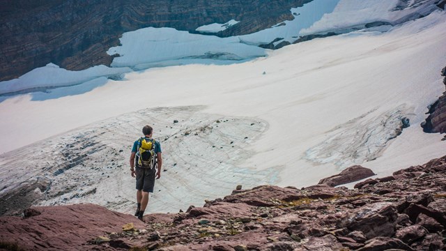
How to see a Glacier
With a little effort you can see a glacier with your own eyes here. Some are visible from the road and others require a day hike. 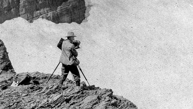
Glacier Repeat Photography
All the glaciers in the park have receded. Click here to see what that looks like. 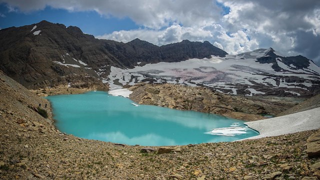
Glacial Geology
Once you know what to look for, viewing Glacier's landscape can seem like reading a textbook on the geologic effects of glaciation. 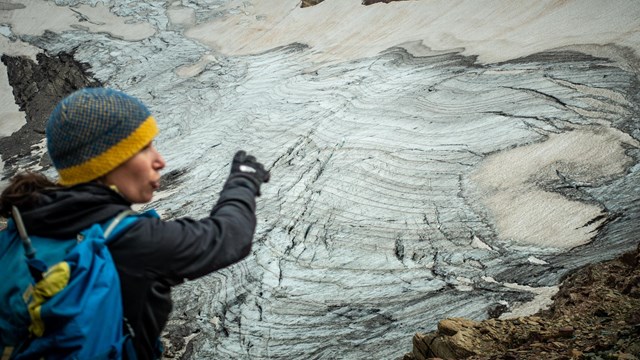
Learn about the USGS Benchmark Glaciers
The U.S. Geological Survey Benchmark Glacier Project is one of the longest running studies of glaciers on Earth. 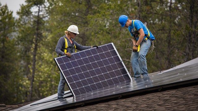
Sustainability
Learn about what Glacier National Park is doing to reduce carbon emissions. |
Last updated: September 9, 2025