Private Stock Use

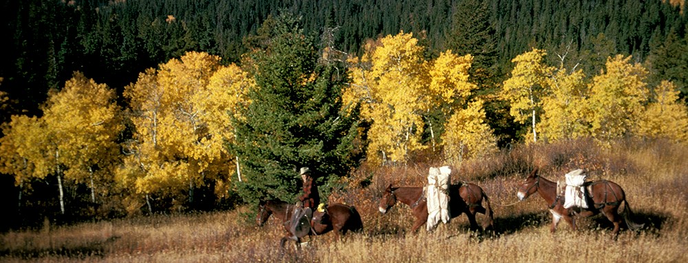
mounted rider leads pack string past yellow aspen grove
Vintage trip into the Belly River

NPS

Where to Ride  /  Area Limits  /  Low Impact Stock Use  /  Overnight Camping  /  Loading Ramps  /  Trails Closed to Stock  /  Crossing the Border  /  Trails with 20 Head Limit
 

Where to Ride

Most trails in the park are open to use by horses, mules, and donkeys, but some are not. Additionally, wildlife activity, steep snowbanks, saturated or flooded trails, and extended periods of wet weather may restrict stock use temporarily. See our trail status page or visit park ranger stations and forest service ranger stations for updates on trails and river crossing conditions.

Stock are always prohibited on Going-to-the-Sun Road and Camas Road, and are permitted on all other paved roads only when restricted to vehicles. Unimproved roads where stock are permitted include Old Flathead Ranger Station Road from the concession barn, the spur road to the Apgar Lookout Trailhead, and (when closed to vehicles) both Bowman Lake Road and Inside North Fork Road.

Return to Top


Area Limits

  • Wilderness campgrounds have designated capacities for numbers of people and stock that cannot be exceeded. Overnight limits for specific campgrounds may not be exceeded for day use stop-overs.
  • Up to eight head may be taken into areas that do not allow overnight use.
  • Parties which exceed limits may pass through an area but may not remain.

Return to Top


Low Impact Stock Use

Please comply with Leave No Trace ethics in addition to the following regulations and guidelines:

Feed

  • Due to problems with noxious weeds, feeding hay at trailheads or wilderness campgrounds is prohibited.
  • Grazing of stock is not permitted. Stock users need to pack supplementary feed grain or pellets fee of noxious weed seeds.
  • Transporting hay into or through Glacier is prohibited, except on the portion of US Highway 2 which passes through the park.
  • Feed must be hung out of reach of bears using an established food hanging device or an NPS-approved, bear-resistant feed container.

Area Use

  • Stock are not permitted in auto campgrounds.
  • Scatter manure after camping or stopping for long periods and smooth out any ruts or holes.
  • Stock are not permitted in the camping areas of wilderness campgrounds. Load and unload at the hitching rails provided.
  • Cross-country riding, loose herding, and trailing are prohibited. Stay on designated trails and roadways approved for stock use.
  • Hikers are required to stand quietly on the lower side of the trail and yield right-of-way to stock. Most hikers don’t know and understand the need for this procedure, so stock users are encouraged to courteously coach them on proper meeting protocol.

Hitching and Tethering

  • When not being used, pack and saddle stock must be tethered. Horses or mules that are nervous "diggers" or "pawers" should be hobbled when tied to prevent unnecessary damage.
  • Always use hitching rails where provided. Where there are none, tie a rope between two trees away from the trail and hitch the stock to the rope. This avoids damage to the tree and trampling around the root system.
  • Tie at least 200 feet (61 m) from streams or lakes.
 

Camping

Wilderness Camping
Permits for wilderness campsites are issued for periods of up to six nights and may be obtained at ranger stations and wilderness permit offices. Reservations may be requested for a fee. Competition is very high in July and August, and stock users are encouraged to plan overnight trips after this period. When planning to use stock on a wilderness overnight trip, be aware that certain campsites are not available due to size or resource considerations. Please see our Wilderness Camping page for more information.

Front-Country Camping
Stock users may keep up to ten head of stock at the Bowman Lake Corral while they camp at Bowman Lake Campground (about ¼ mile away). Prior permission must be obtained from the Polebridge Ranger Station (406) 888-7842.

Stock users may camp for one night in Two Medicine. For more information and to obtain permission, contact the Walton-Two Medicine District Ranger or designee at (406) 226-4484.

Camping Outside the Park with Stock

  • Glacier Meadow RV Park, 16 miles west of East Glacier Park (406) 226-4479
  • Johnson’s Campground, St. Mary (406) 732-4207
  • Flathead and Lewis and Clark National Forests. Contact the Hungry Horse Ranger Station for information (406) 387-3800.

Return to Top


Loading Ramps

If you are using a stock truck, there are loading ramps located at the sites listed below. Be sure not to block ramps with unattended vehicles.

Belly River Area

  • Chief Mountain Trailhead

Cut Bank Valley

  • Cut Bank Trailhead

Lake McDonald Valley

  • Apgar Horse Concession
  • Lake McDonald Ranger Station
  • Lincoln Lake Trailhead
  • Packers Roost Trailhead
  • Sperry Trailhead near the camp store

Many Glacier Valley

  • Many Glacier Horse Concession

North Fork Area

  • Bowman Lake
  • Camas Creek Trailhead
  • Kintla Lake
  • Kishenehn Trailhead
  • Logging Creek Ranger Station

South Boundary Area

  • Coal Creek Trailhead
  • Fielding Access Road Trailhead
  • Nyack Trailhead
  • Walton Ranger Station

Two Medicine

  • Scenic Point Trailhead


Trails Closed to Stock

Lake McDonald Valley

  • Avalanche Lake Trail
  • Loop parking area to the junction of the Granite Park Trail
  • Sperry Chalet to Sperry Glacier
  • Trail of the Cedars

Logan Pass

  • Hidden Lake Trail
  • Highline Trail from Logan Pass to Granite Park Chalet

Many Glacier Valley

  • Apikuni Falls Trail
  • Grinnell Glacier Trail
  • Hidden Falls Trail
  • Iceberg Lake hitch rail to Iceberg Lake
  • Josephine Walkway
  • Swiftcurrent Lake Nature Trail

St. Mary Valley

  • Baring Falls Trail from Sunrift Gorge

Two Medicine Valley

  • Dawson Pass to the Cutbank Pass Trail junction
  • Running Eagle Falls Nature Trail
  • Spur to Cobalt Lake from the Two Medicine Pass Trail

Other Areas

  • Hole-in-the-Wall spur from the Boulder Pass Trail
  • Forest and Fire Nature Trail
  • Spur to Lake Francis


Crossing the Border

Special provisions and restrictions apply when crossing the International Boundary with stock. Canadian stock owners must have proof of a Coggins test endorsed by a veterinarian. Call the Montana State Veterinarian office at (406) 444-2043 for more information.

US stock owners must obtain a horse use permit from Piegan/Carway Customs; each animal must have had a Coggins test endorsed by a veterinarian and must enter and exit at Piegan/Carway Border Crossing. Length of stay is 72 hours. Call the Customs office at (403) 653-3009 for more details.

Return to Top


Day Use Head Limits

There is a ten-head limit for day use on most trails that allow stock.The following trails have a twenty-head limit for day use:

Lake McDonald Valley

  • Apgar Flats Trail

  • Apgar Lookout Trail

  • Apgar Mountain Loops off the Lower McDonald Creek Trail

  • Avalanche Trail #56 from the Lake McDonald Lodge to the junction of the Avalanche Lake Trail and Trail of the Cedars

  • Lake McDonald Lodge Trailhead to Sperry Chalet

  • Packers Roost to Granite Park Chalet

  • Upper McDonald Creek Trail

Many Glacier Valley

  • Cracker Lake Trail

  • Grinnell Lake Horse Trail

  • Josephine Lake Horse Trail

  • Red Gap Pass Trail from Many Glacier Road to Poia Lake

  • Swiftcurrent Pass Trail from Many Glacier to Granite Park Chalet

West Side Roads

  • Old Flathead Ranger Station Road from the concession barn

  • When closed to vehicles, Bowman Lake Road and Inside North Fork Road

Return to Top

Last updated: July 13, 2023

Park footer

Contact Info

Mailing Address:

PO Box 128
West Glacier, MT 59936

Phone:

406-888-7800

Contact Us