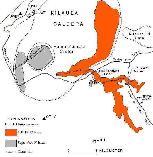
July 1974 Summit Eruption

Map detailing the location of the July 1974 eruption at the summit of Kīlauea
USGS diagram of the July 1974 eruption
On July 19, 1974, fissures opened up in multiple places at the summit of Kīlauea, creating large lava fountains and dramatic views from vantage points like Volcano House. Lava flows crossed Chain of Craters Road and spilled into Lua Manu, while additional fissures cascaded lava into Keanakākoʻi Crater and Kaluapele (Kīlauea caldera).

The most dramatic activity lasted less than a day, with low fountaining continuing on the caldera floor until the event fully concluded on July 22.
 
Lava flow crossing a road surrounded by rainforest
Lava flow crossing Chain of Craters Road near Puhimau crater (USGS Photo)
 
Lava fountaining from a fissure in the wall of a crater
Erupting fissures in Keanakākoʻi on July 19. The 1974 eruption filled the crater with nearly 20 feet (6 m) of lava. (USGS Photo/R. Tilling)
 
Aerial view of lines of erupting lava fountains sending out fumes and cascading lava into a pit crater and larger caldera
Aerial view of erupting fissures in Kīlauea caldera and on either side of Keanakākoʻi crater, July 19, 1974 (USGS Photo)
 
A group of people, including a woman looking backward, at an overlook facing a volcanic caldera and distant lava fountains
Visitors watching the events of July 19 from Waldron Ledge (USGS Photo/R.L. Hofmann)
 
Glowing orange molten lava flow on the floor of a caldera with forested walls
Lava flow on the floor of Kaluapele (Kīlauea caldera), Saturday July 20, 1974 (USGS Photo)
 
Aerial view of solidified lava flows near a pit crater, crossing a road into a larger caldera
Aerial image of the area surrounding Keanakākoʻi after the July 1974 eruption (USGS Photo/Rodriquez)


Last updated: March 11, 2021

Park footer

Contact Info

Mailing Address:

P.O. Box 52
Hawaii National Park, HI 96718

Phone:

808 985-6011

Contact Us