Winter hours begin on October 20, 2024: the visitor center and park trails will be open five days a week, from Thursday through Monday. Closed on Tuesdays and Wednesdays. There is no trail access when the visitor center is closed. More
Stage II Fire Restrictions will be in effect beginning Tuesday, January 21, 2025.
Due to high fire danger, El Morro will implement Stage II Fire Restrictions. These include no campfires. No smoking except in an enclosed vehicle or other authorized area.
Atsinna Pueblo was home to many during the 13th century.
NPS Photo
Ancient Villagers
Villages Arise
Emerging from a hunter-gatherer culture some 2,000 year ago, the ancestral Puebloans were agriculturalists who built small villages along streams throughout the Southwest. Here they would grow crops such as maize, beans, and squash, in addition to harvesting native plants and hunting. Eventually these small pueblos would evolve into larger dwellings with thriving communities throughout the El Morro valley.
Atsinna Pueblo, seen along the Headland Trail, is the largest dwelling within El Morro. Archeological investigations show that this structure would have been utilized starting around 1275 CE. Perhaps these communities were not meant to be permanent; Atsinna was only occupied for around 75-100 years.
Excessive heat, drought, or change in cultural practices may have been reasons to leave Atsinna and continue their journey beyond.
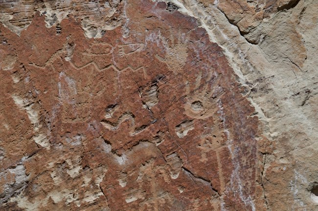
Petroglyphs are just one reminder of the original inhabitants of this land.
NPS Photo/J.Ellis
Messages Left Behind
The rock markings the ancestral Puebloans left behind are a language that may communicate both the mundane and the spiritual. Petroglyphs found throughout the monument depict different cultures, ideas, and messages over hundreds of years. Created by pecking the rock surface using a chisel or antler, these messages have withstood the passing of time. Some 200 petroglyphs are protected within El Morro, in addition to several pictographs, or rock paintings, many of which can be viewed from the Inscription Loop Trail.
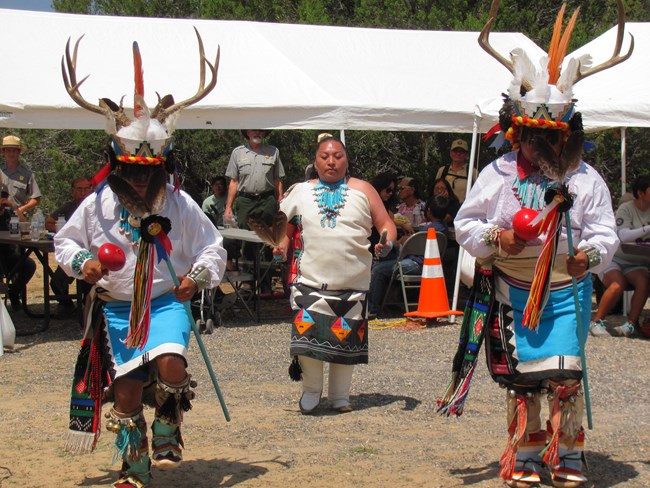
Indigenous communities around El Morro have rich cultural traditions.
NPS Photo
Connections Today
For many Indigenous people, Atsinna and related sites continue to be important places to them-part of their larger homelands that once stretched far beyond the boundaries seen today.
Many people called this valley home. The Zuni (A:shiwi), whose ancestors resided in the pueblos atop El Morro, call the sandstone bluff Atsinna, or “place of writing on the rock.”
Today, the Zuni (A:shiwi), Navajo (Diné), and Acoma continue to have close cultural ties to Atsinna Pueblo and the lands around El Morro National Monument.
Recent efforts led by Canyon de Chelly archeologists, in collaboration with the University of New Mexico and the Southern Arizona Office to document and analyze the structural integrity of the puebloan ruins.
This lesson is part of a series teaching about the World War II home front in Los Alamos County, New Mexico designated as an American World War II Heritage City. The lesson contains primary sources, a secondary source, and pictures. The sources provide insight on Native American contributions to the home front in Los Alamos, like Dr. Floy Agnes Lee, in contrast to the usually limited employment opportunities for Native Americans. There are also resources on Pueblo pottery.
This lesson is part of a series teaching about the World War II home front with Los Alamos County, New Mexico designated as an American World War II Heritage City. The lesson has photographs, background reading, and interview and memoir excerpts to support learners’ understandings about the home front contributions of the people in Los Alamos. It explores the history of the land and its people, along with sharing perspectives from a child who grew up there and a US soldier.
White Sands National Monument has been visited by human groups intermittently over the past 11,000 years. Due to the physical properties of gypsum, remnants of some of those occupations are preserved in a unique form.
Hi! My name is Kathy and this is my friend Gentle Rain who lived in Mesa Verde 750 years ago. She helped me become a junior ranger, and now we both want to help you. As you explore the park online and complete activities, you will learn about Gentle Rain’s culture, discover items her family and friends once used, and see the types of homes they lived in. Just download the booklet and follow our directions, and you will earn your virtual ranger badge in no time!
Locations:Arches National Park, Aztec Ruins National Monument, Bandelier National Monument, Canyon de Chelly National Monument, Canyonlands National Park, Capitol Reef National Park, Chaco Culture National Historical Park, El Malpais National Monument, El Morro National Monument, Glen Canyon National Recreation Area, Grand Canyon National Park, Hovenweep National Monument, Hubbell Trading Post National Historic Site, Mesa Verde National Park, Natural Bridges National Monument, Navajo National Monument, Petrified Forest National Park, Petroglyph National Monument, Rainbow Bridge National Monument, Salinas Pueblo Missions National Monument, Sunset Crater Volcano National Monument, Walnut Canyon National Monument, Wupatki National Monument, Yucca House National Monumentmore »
The Colorado Plateau is centered on the four corners area of the Southwest, and includes much of Arizona, Utah, Colorado, and New Mexico.
Locations:Aztec Ruins National Monument, Chaco Culture National Historical Park, Wupatki National Monument
On my drive out west toward Grand Canyon this year, I had the chance to stop at a few Ancestral Puebloan sites – namely, Bandelier, Chaco Culture, and Aztec Ruins. Having worked and spent some time around these types of sites before, I felt like I was seeing and appreciating these special places on a much deeper level than even I realized was possible.
Explore the rugged, volcanic landscape of northern New Mexico. Archaeological ruins and petroglyphs give a glimpse into the lives of the Ancestral Puebloans who settled the area hundreds of years ago.
Locations:Amistad National Recreation Area, Aztec Ruins National Monument, Big Bend National Park, Carlsbad Caverns National Park, Casa Grande Ruins National Monument, Coronado National Memorial, Gila Cliff Dwellings National Monument, Glen Canyon National Recreation Area, Grand Canyon National Park, Guadalupe Mountains National Park, Mesa Verde National Park, Montezuma Castle National Monument, Pecos National Historical Park, Petrified Forest National Park, Rainbow Bridge National Monument, Rio Grande Wild & Scenic River, Saguaro National Park, Tonto National Monument, Tumacácori National Historical Park, Tuzigoot National Monumentmore »
In the arid Southwest, water means life, and prehistorically, rivers were the lifelines of the people.
Locations:Alibates Flint Quarries National Monument, Bent's Old Fort National Historic Site, Capulin Volcano National Monument, Chickasaw National Recreation Area, Fort Larned National Historic Site, Fort Union National Monument, Lake Meredith National Recreation Area, Lyndon B Johnson National Historical Park, Sand Creek Massacre National Historic Site, Washita Battlefield National Historic Sitemore »
The Plains of the Southwest include the southern Great Plains, the High Plains, Llano Estacado (Staked Plains), and Edwards Plateau.