NPS Sites Along Passive Continental Margins
Several National Park System sites on the Atlantic and Gulf of Mexico coasts lie along modern passive continental margins formed when Africa and South America rifted away from North America. Other NPS sites in the Colorado Plateau region, including Grand Canyon National Park, showcase sedimentary layers deposited along an ancient passive continental margin.

Modified from “Parks and Plates: The Geology of our National Parks, Monuments and Seashores,” by Robert J. Lillie, New York, W. W. Norton and Company, 298 pp., 2005, www.amazon.com/dp/0134905172.
Passive Continental Margins—Modern
- ASIS—Assateague Island National Seashore, Maryland & Virginia—[Geodiversity Atlas] [Park Home]
- BISC—Biscayne National Park, Florida—[Geodiversity Atlas] [Park Home]
- CANA—Canaveral National Seashore, Florida—[Geodiversity Atlas] [Park Home]
- CACO—Cape Cod National Seashore, Massachusetts—[Geodiversity Atlas] [Park Home]
- CAHA—Cape Hatteras National Seashore, North Carolina—[Geodiversity Atlas] [Park Home]
- CALO—Cape Lookout National Seashore, North Carolina—[Geodiversity Atlas] [Park Home]
- CUIS—Cumberland Island National Seashore, Georgia—[Geodiversity Atlas] [Park Home]
- FIIS—Fire Island National Seashore, New York—[Geodiversity Atlas] [Park Home]
- DRTO—Dry Tortugas National Park, Florida—[Geodiversity Atlas] [Park Home]
- EVER—Everglades National Park, Florida—[Geodiversity Atlas] [Park Home]
- GUIS—Gulf Islands National Seashore, Florida & Mississippi—[Geodiversity Atlas] [Park Home]
- PAIS—Padre Island National Seashore, Texas—[Geodiversity Atlas] [Park Home]
Passive Continental Margins—Ancient
- CANY—Canyonlands National Park, Utah—[Geodiversity Atlas] [Park Home]
- CEBR—Cedar Breaks National Monument, Utah—[Geodiversity Atlas] [Park Home]
- GRCA—Grand Canyon National Park, Arizona—[Geodiversity Atlas] [Park Home]
- PEFO—Petrified Forest National Park, Arizona—[Geodiversity Atlas] [Park Home]
- WACA—Walnut Canyon National Monument, Arizona—[Geodiversity Atlas] [Park Home]
Introduction
Where tectonic plates diverge they can rip a continent apart and eventually open an entire ocean. The continents slowly drift away from one another as the ocean widens. The beautiful beaches of the nine national seashores and three national parks on the Atlantic Ocean and Gulf of Mexico lie along passive continental margins that developed as Europe, Africa, and South America drifted away from North America beginning about 200 million years ago.
The Atlantic and Gulf coasts are passive continental margins because they lack the high levels of earthquake, volcanic, and mountain-building forces characteristic of active continental margins (such as the current U. S. West Coast) that are right at plate boundaries. But in the distant past the western edge of North America was much like today’s East Coast. The spectacular layers of rock in Grand Canyon and other National Park Service sites on the Colorado Plateau formed as the ancient passive continental margin gradually subsided and was covered by sediment.
Cape Cod National Seashore, Massachusetts

The beautiful beaches of the East Coast are part of a passive continental margin formed as the Atlantic Ocean opened and the edge of North America subsided and was covered by thick layers of sand and mud.
NPS photo.
Gulf Islands National Seashore, Florida and Mississippi

The edge of the Gulf of Mexico is a passive continental margin formed as South America and the Yucatan Peninsula ripped away from North America, forming beautiful beaches and barrier islands.
NPS photo.
Grand Canyon National Park, Arizona

The layering in the upper part of the canyon formed over 200 million years ago, when the Colorado Plateau region was part of an ancient passive continental margin.
NPS photo.
Modern Passive Continental Margin
The overall form of a passive continental margin results from the crust thinning from the continent to the ocean. Where crust is thick, its buoyancy makes it stick up far above the denser mantle; conversely, thin oceanic crust sits down much lower. The thickness difference results in the top of oceanic crust sitting down about 3 miles (5 kilometers) lower than continental crust.
Continental Rift

Passive continental margins abutting the Atlantic Ocean and Gulf of Mexico developed as a large continent, Pangea, ripped apart about 200 million years ago.
New Ocean Basin

Rift valleys formed as the thick continental crust (orange) ripped apart and thined. A narrow basin, with thin oceanic crust (black), developed as the two continental fragments split apart.
Mature Ocean Basin

The continents moved away from one another as parts of different tectonic plates. The transitions from thick continental to thin oceanic crust are passive continental margins because they are far away from the current plate boundary at the Mid-Atlantic Ridge. Thick sedimentary deposits (yellow) accumulated as the continental margins cooled and subsided.
Modified from “Parks and Plates: The Geology of our National Parks, Monuments and Seashores,” by Robert J. Lillie, New York, W. W. Norton and Company, 298 pp., 2005, www.amazon.com/dp/0134905172.
Tectonic Development of the Atlantic Ocean and Gulf of Mexico
About 300 million years ago Europe, Africa, and South America collided with North America, forming a supercontinent called Pangea. As Pangea ripped apart 200 million years ago, Europe, Africa, and South America pulled away from North America, creating the Atlantic Ocean and Gulf of Mexico. The Atlantic and Gulf coasts show the classic form of a passive continental margin: a low-lying coastal plain, broad continental shelf, then a steep continental slope, gentle continental rise, and flat abyssal plain. This topography is a consequence of the transition from thick continental to thin oceanic crust. The high areas (coastal plain and shelf) are underlain by continental crust, while oceanic crust underlies low regions (continental rise and abyssal plain).

The supercontinent of Pangea formed 300 million years ago as an ancient ocean closed. A chain of mountains formed as the continents collided, including the Marathon, Ouachita and Appalachian mountians in the United States.
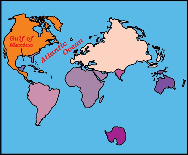
The Atlantic Ocean and Gulf of Mexico formed as Pangea ripped apart.
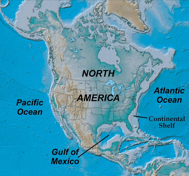
The thick continental crust of North America is surrounded by crust of the continental shelf (grey color) that thinned and submerged as the Atlantic Ocean and Gulf of Mexico opened.
Modified from “Parks and Plates: The Geology of our National Parks, Monuments and Seashores,” by Robert J. Lillie, New York, W. W. Norton and Company, 298 pp., 2005, www.amazon.com/dp/0134905172.
NPS Sites along Atlantic and Gulf Coasts

Map of eastern United States, showing locations of National Park Service sites along the coasts of the Atlantic Ocean and Gulf of Mexico. The coastal plain and continental shelf mark the current transition from thick crust of North America to thin crust of the adjacent oceans. An earlier continental margin is now covered by the Appalachian – Ouachita – Marathon mountain chain (discussed in the “Collisional Mountain Range” part of these webpages). National parks and seashores lie on the gently-sloping surface of the coastal plain and continental shelf, deriving their sediments from the eroding mountains. Dry Tortugas and Biscayne national parks in Florida lie on the very edge of the continental shelf. Acadia National Park is located where the Appalachian Mountains extend to the coast in Maine.
Modified from “Parks and Plates: The Geology of our National Parks, Monuments and Seashores,” by Robert J. Lillie, New York, W. W. Norton and Company, 298 pp., 2005, www.amazon.com/dp/0134905172.
Source of Sediment in NPS Sites along Atlantic and Gulf Coasts
The beautiful sand beaches in national seashores are the products of sedimentary deposition. Those sediments can be quite different, depending on their origins. During the last ice age, up until about 15,000 years ago, a great continental ice sheet extended down from Canada and covered all of New England. At its terminus it dumped large amounts of sedimentary debris into a terminal moraine, forming Long Island in New York State and the islands of Nantucket and Martha’s Vineyard off Massachusetts. Recessional moraines formed as the climate warmed and the ice melted and receded northward. Lakes developed between the receding ice and moraines, including one very large one where mud, salt, and sand were deposited in what is now Cape Cod in Massachusetts. As the climate further warmed, the ice sheet disappeared from the region, and sea level rose. The beaches of Fire Island and Cape Cod national seashores are glacial moraine and lake deposits that have been reworked by wave action since the last ice age, forming eroded cliffs, sand spits, and barrier islands.

Fire Island National Seashore, New York
Fire Island has deposits from the continental ice sheet (terminal moraines) that were reworked by wave action.
NPS photo.

Cape Hatteras National Seashore, North Carolina
Cape Hatteras contains mixed sedimentary grains transported by rivers from the Appalachian Mountains.
NPS photo.

Dry Tortugas National Park, Florida
The beaches of Dry Tortugas at the western end of the Florida Keys are fragments of shells broken up by wave action, and coral reefs developed in the shallow, warm waters.
NPS photo.

Gulf Islands National Seashore, Florida and Mississippi
The pure white sands of Gulf Islands National Seashore in Florida and Mississippi are grains of quartz derived from the Southern Appalachian Mountains.
Photo courtesy of Robert J. Lillie.
Glacial ice did not extend as far as the Atlantic and Gulf coasts of the southeastern United States. Much of the sedimentary deposits in those areas are derived from erosion of the nearby North American continent, particularly the Appalachian/Ouachita/Marathon mountain range. Most of the sedimentary material making up Assateague Island, Cape Hatteras, Cape Lookout, Cumberland Island, and Canaveral national seashores on the Atlantic Coast came from erosion of the Appalachian Mountains. The southern portion of Florida is some distance from the mouths of large rivers that would carry a lot of clastic (eroded) sedimentary grains. Instead, the beaches in those areas contain shell fragments made mostly of calcium carbonate, material much softer than the sand and silt found on beaches farther north. The warm waters produce fabulous coral reefs around Biscayne, Everglades, and Dry Tortugas national parks.
At Gulf Islands National Seashore along the Florida Panhandle and Mississippi coast, the incoming sediment is primarily from the Apalachicola River a bit farther east. Those sediments are derived from erosion of a small part of the Southern Appalachian Mountains and contain a lot of the mineral quartz. Quartz is a hard substance that does not dissolve in cold water, while other minerals may dissolve or are broken into fine grains during transport. Upon entering the Gulf of Mexico, the sediment is carried westward by the longshore current. The beaches of Gulf Islands National Seashore are so spectacularly white because they are composed of more than 99% clear quartz grains. The finer material is winnowed out by the current and carried farther west, where it mixes with mud carried from the interior of the continent by the Mississippi River and deposited on the Louisiana and East Texas coast. It is not until the region of Padre Island National Seashore that the mud content lessens and sandy beaches once again appear.
Topography of a Passive Continental Margin
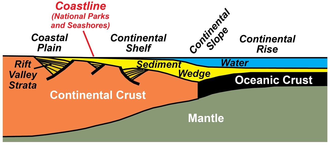
The topography and bathymetry (underwater topography) of a passive continental margin result from the underlying transition from continental to oceanic crust. Because the oceanic crust is thinner (and thus less buoyant) than the continental crust, its surface is lower. As the subsiding ocean basin floods with water, a wedge of sedimentary layers (sandstone, shale, and limestone) accumulates along the continental margin. Older sedimentary and volcanic layers fill rift valleys that formed when the continent initially ripped apart. The ocean water is shallow over the rifted continental crust, a region termed the continental shelf. The water level deepens along the continental slope to the continental rise, which overlies the thinner oceanic crust. Beaches and barrier islands on the coastal plain and continental shelf of the Atlantic Ocean and Gulf of Mexico are the sites of several National Park Service sites.
Modified from “Parks and Plates: The Geology of our National Parks, Monuments and Seashores,” by Robert J. Lillie, New York, W. W. Norton and Company, 298 pp., 2005, www.amazon.com/dp/0134905172.
The change from thick continental crust to much thinner oceanic crust is responsible for the development of the topography and bathymetry (underwater topography) on the eastern seaboard, and ultimately the wonderful beaches and islands that comprise the national parks and seashores. As the continent rips apart the continental crust stretches and thins; it eventually sinks below sea level and is covered by layers of sand, silt and mud. The subsidence and sedimentation result in a thin veneer of sediment lying just above sea level at the coastal plain and a thickening wedge of sediment beneath shallow water of the continental shelf. Farther out to sea, where thin oceanic crust is encountered, the water deepens abruptly at the continental slope, then more gradually along the continental rise, to the flat abyssal plain.
Changing Coastline as Sea Level Rises and Falls
Picturesque beaches and barrier islands are the hallmark of the national parks and seashores on the Atlantic and Gulf coasts. Those features are part of the sediment wedges above the transition from continental to oceanic crust. But coastlines and barrier islands are features that, geologically speaking, change positions rapidly, depending on global sea level, sediment supply, and rate of subsidence of the continental margin. The national parks and seashores lie along a very gentle slope that extends hundreds of miles from the landward edge of the coastal plain to the seaward edge of the continental shelf. Over a distance of about 300 miles (500 kilometers), elevation changes by only about 1000 feet (300 meters), from 400 feet (120 meters) above sea level to 600 feet (200 meters) below. The average slope is only about 0.3 degrees!

The position of the coastline is sensitive to changes in sea level. During the peak of the last ice age, about 18,000 years ago, the coastline was near the edge of the continental shelf. It would have been possible to walk all the way out to Dry Tortugas National Park! At other times during the past 5 million years, sea level was higher than today, so that areas of the coastal plain were flooded. National parks and seashores lie in the zone between the maximum and minimum levels.
Modified from “Earth: Portrait of a Planet, by S. Marshak, 2001, W. W. Norton & Comp., New York.
As Earth’s climate fluctuates, sea level drops when water is concentrated in polar ice caps, and rises as the ice melts. The shoreline migrates back and forth, from near the edge of the continental shelf during the peak of ice ages, to somewhere landward of its current position when climate warms. During the peak of the last ice age, when sea level was about 400 feet (120 meters) lower, the Atlantic and Gulf coastlines were about 100 miles (160 kilometers) to the east and south, respectively. Lands that now make up our national seashores were high and dry at that time, developing their current morphology as the Earth warmed and the coast migrated to its current position over the past 18,000 years. At other times, during warmer climate, the coastlines were 70 miles (100 kilometers) farther inland.
On a shorter time scale, narrow spits and offshore barrier islands migrate in directions parallel to the shoreline. Natural movements of water, called longshore currents, transport large volumes of sand and mud. The current erodes material from the upstream side of an island, then carries and deposits it on the downstream side. Over a period of just a few decades, barrier islands, such as those in Gulf Islands National Seashore, can migrate several miles.
Migration of Barrier Island

West Ship Island in Gulf Islands National Seashore, Mississippi
The longshore current erodes sand from the “upstream” end of the island and deposits it on the other tip. Through the years, the island gradually moves “downstream.”
NPS photo by Mike Hobbs.
Ancient Passive Continental Margin
The sandy beaches of our national parks and seashores along the Atlantic Ocean and Gulf of Mexico are just the top portions of thick sedimentary layers that drape the eastern edge of North America. Imagine what would happen if the whole East Coast were to rise upward, so that deep canyons carved through those layers. But we needn’t just imagine – we can go to places like Grand Canyon National Park and see layers similar to those that lie beneath the beaches of Cape Hatteras, Padre Island, and other national seashores.
Colorado Plateau Region during the Paleozoic Era

Near the beginning of the Paleozoic Era, 500 million years ago, western North America was smaller than it is today, and near the equator. The Colorado Plateau region was along a passive continental margin. The red star represents the area of Grand Canyon National Park. NAM = North America; SIB = Siberian craton; Bal = Baltica; Gon = Gondwanaland.
Adapted from Ronald Blakey, Northern Arizona University.

The Colorado Plateau region straddled a shallow inland sea that periodically rose and fell, lapping over the edge of the continent. In a plate tectonic framework, the area spanned the continental shelf and coastal plain of an ancient passive continental margin.
Modified from An Introduction to Grand Canyon Geology, by L. G. Price, 1999, Grand Canyon Association, Grand Canyon, Arizona.

The region included the coastal plain as well as shallow water of the continental shelf. Rift valley strata from an earlier breakup of the continent are called the Grand Canyon Supergroup, whereas the igneous and metamorphic rocks of the inner portions of Grand Canyon are part of the underlying, older continental crust.
Modified from “Parks and Plates: The Geology of our National Parks, Monuments and Seashores,” by Robert J. Lillie, New York, W. W. Norton and Company, 298 pp., 2005, www.amazon.com/dp/0134905172.
The shapes of continents, and their positions relative to one another, are images that are deeply imbedded in our minds. But continents are constantly evolving through time. The western portion of North America was not even there 500 million years ago. Instead, there was a passive continental margin, much like the East Coast and Gulf Coast today, subsiding and being covered by sedimentary layers. North America was also much farther south than it is today, straddling the equator. The deposits along the continental shelf were similar to those forming today around the Florida Keys and Bahamas – limestone layers intermingled with sandstone and shale, and including fossils of tropical plants and animals.
National Park Service Sites on the Colorado Plateau
The Colorado Plateau is a region of high elevation in the southwestern part of the United States. But the uplift of the Plateau is a relatively recent event – within the past 70 million years. During much of the Paleozoic and Mesozoic eras, from about 540 to 170 million years ago, the region was part of an ancient passive continental margin. Since then, the continent has grown westward as oceanic material and blocks of thicker crust were added to its edge during tectonic plate convergence. Sedimentary layers of the ancient passive margin were left stranded within the interior of the continent. As the Colorado Plateau rose upward, rivers carved downward, exposing those layers on the walls of canyons.
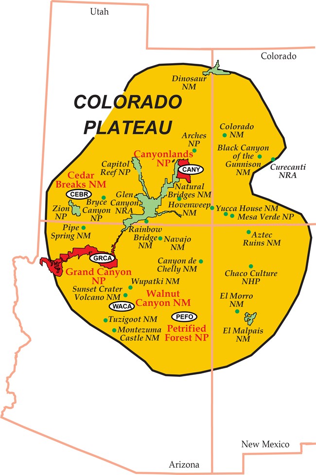
Colorado Plateau Parks
NPS sites on the Colorado Plateau reveal an ancient passive continental margin on the western edge of the North American continent. The margin formed during the Paleozoic Era and persisted until the middle part of the Mesozoic Era. Some of the sedimentary layers of the NPS sites that are highlighted in red text and with 4-letter park codes were deposited along the ancient passive margin. Mesozoic age strata of some other sites (Zion, Capitol Reef, Navajo, Arches) might also be passive continental margin layering.

Canyonlands National Park, Utah
Photos courtesy of Jo Ann Callahan.

Walnut Canyon National Monument, Arizona
Photo courtesy of Robert J. Lillie.
The passive margin strata in the Grand Canyon, as well as layers in some other parks on the Colorado Plateau, were deposited as shallow seas periodically lapped back and forth across the ancient continental shelf and coastal plain of western North America. Along shorelines, where currents and wave action were vigorous, coarse-grained sand was deposited. Farther offshore, in calmer waters, finer-grained silt and mud accumulated. Still farther out, dissolved organic material settled out on the ocean floor as fine lime mud. The typical rocks that formed were sandstone in the nearshore and coastal plain environment, then progressively shale and limestone farther out on the continental shelf.
Numerous advances and retreats of the sea led to the layered sequences of rock at Grand Canyon and other parks on the Colorado Plateau. In today’s dry climate of the Southwest, sandstone and limestone layers erode very slowly, forming steep cliffs, while more-easily eroded shale layers result in gentle slopes. The overall effect is the “stair step” appearance seen in the layering at Grand Canyon and other parks.
The Layers in Grand Canyon National Park Tell a Plate-Tectonic Story

Grand Canyon Strata
The Colorado River has eroded through Paleozoic passive continental margin strata and older rocks, forming the Grand Canyon.
Adapted from “A Geology Training Manual for Grand Canyon National Park,” by Stacy S. Wagner, M. S. Thesis, Oregon State University, 2002.
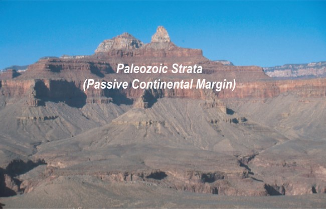
Upper Canyon
The upper portion of the canyon reveals continental shelf and coastal plain sedimentary layers of the ancient passive continental margin.
Photo courtesy of Robert J. Lillie.

Middle Canyon
The Grand Canyon Supergroup consists of continental rift valley strata preserved beneath the passive margin layers.
NPS photo.

Lower Canyon
In the deeper portions of the canyon, the river has cut down to the older metamorphic and igneous rocks of the underlying continental crust.
Photo courtesy of Robert J. Lillie.
The rock layers exposed in canyons in parks on the Colorado Plateau are like the pages of a giant history book. At Grand Canyon National Park, the initial chapters, now seen deep down in the canyon along the Colorado River, tell us about igneous and metamorphic processes that accompanied mountain building more than a billion years ago. Those rocks became part of the hard crust of an ancient continent. As that continent ripped apart, other layers filled rift valleys; those tilted layers can be seen farther up the canyon. Strata in the upper portion of the canyon were deposited along the passive continental margin that developed as a broad ocean opened.
At this time in Earth’s history, most of the landmasses were joined as one giant supercontinent, called Pangea (“pan” means all encompassing, while “gea” refers to the Earth or the land–“Pangea” literally means all the land joined together). This came about 300 million years ago when the southern continents of Africa, South America, Australia, and Antarctica (collectively known as Gondwanaland), along with Europe and Asia, crashed into North America. North America was on the equator, as it slowly drifted northward to its current position. That means that the Colorado Plateau region, including what was to become Petrified Forest National Park, was in the tropics!
There was no California, Oregon or Washington, so that the coast of North America was near the western border of Arizona. The area of Petrified Forest National Park was a coastal lowland, similar to the Amazon Basin of South America today. It was a land dominated by a great river system, with lots of trees, swamps, and meandering streams here and there, and animals similar to alligators, armadillos, and nutria. In addition to the superbly-preserved tree specimens, fossils excavated from the park and surrounding regions include distant ancestors of these tropical reptiles, amphibians and mammals.
Petrified Forest National Park and Continental Drift

The paleogeographic map shows that, during the Late Triassic Epoch, North America straddled the equator and Petrified Forest National Park (white dot on red map of Arizona) was at about 4° north latitude.
Modified from Ron Blakey, Northern Arizona University.

The region was probably similar to the meandering streams and forests of today’s Amazon Basin of South America.
Photo source: www.landreport.com/wp-content/uploads/2008/12/amazon-web.jpg.

Badlands area in Petrified Forest National Park. The Amazon-like landscape has evolved over more that 200 million years from a green tropical forest to red Painted Desert. Layers of the Late Triassic Chinle Formation were buried by younger sedimentary deposits. Arizona is no longer along the Pacific Coast, because ocean islands and fragments of continents later came crashing in, forming California, Oregon, and Washington. The North American continent drifted to mid-latitudes where today's deserts form inland.
Photo courtesy of Robert J. Lillie.

Petrified logs along the Blue Mesa Trail. As the Colorado Plateau lifted upward, younger sedimentary layers eroded away, exposing the Chinle Formation, along with its colorful badlands, petrified logs, and other fossil from an ancient world.
There was no California, Oregon or Washington, so that the coast of North America was near the western border of Arizona. The area of Petrified Forest National Park was a coastal lowland, similar to the Amazon Basin of South America today. It was a land dominated by a great river system, with lots of trees, swamps, and meandering streams here and there, and animals similar to alligators, armadillos, and nutria. In addition to the superbly-preserved tree specimens, fossils excavated from the park and surrounding regions include distant ancestors of these tropical reptiles, amphibians and mammals.
Figures Used
Related Links
Site Index & Credits
Plate Tectonics and Our National Parks
- Plate Tectonics—The Unifying Theory of Geology
- Inner Earth Model
- Evidence of Plate Motions
- Types of Plate Boundaries
- Tectonic Settings of NPS Sites—Master List
Teaching Resources—Plate Tectonics
Photos and Multimedia—Plate Tectonics
Geological Monitoring—Plate Tectonics
Plate Tectonics and Our National Parks (2020)
-
Text and Illustrations by Robert J. Lillie, Emeritus Professor of Geosciences, Oregon State University [E-mail]
-
Produced under a Cooperative Agreement for earth science education between the National Park Service's Geologic Resources Division and the American Geosciences Institute.
Last updated: February 11, 2020
