Showing results 1-10 of 80
- Locations: Black Canyon Of The Gunnison National Park, Curecanti National Recreation Area
- Offices: Inventory and Monitoring Division, Natural Resource Stewardship and Science Directorate, Northern Colorado Plateau Inventory & Monitoring Network
At Black Canyon of the Gunnison National Park and Curecanti National Recreation Area, long-term vegetation monitoring provides park managers with useful information for decision making on topics including changes in climate, grazing, and fire management. A recent report summarizes monitoring from 2011 to 2022 of vegetation and soil conditions provides management recommendations for their conservation.
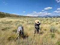
- Locations: Curecanti National Recreation Area
- Offices: Inventory and Monitoring Division, Natural Resource Stewardship and Science Directorate, Northern Colorado Plateau Inventory & Monitoring Network

Invasive exotic plants are one of the most significant threats to natural resources in the national parks today. To provide early warning of weed invasions, the Northern Colorado Plateau Network monitors target plants in park areas where they are likely to first establish: along roads, trails, and waterways. Find out what we've learned at Curecanti National Recreation Area.
- Locations: Curecanti National Recreation Area
- Offices: Inventory and Monitoring Division, Northern Colorado Plateau Inventory & Monitoring Network

Northern Colorado Plateau Network’s scientists use satellite observations of vegetation condition in Curecanti National Recreation Area with climate data over time to reveal how climate influences plant production and phenology. Knowing which of the wide range of 16 vegetation assemblages found in Curecanti are more or less sensitive to climate change can help managers understand what to expect over the next few decades, and plan for the changes coming their way.
- Arches National Park
How Dry Will Parks Get? Water Deficit Tells Us
- Locations: Arches National Park

Dryness has an outsized impact on nature in parks, but temperature and precipitation are poor indicators.
- Locations: Dinosaur National Monument
- Offices: Inventory and Monitoring Division, Northern Colorado Plateau Inventory & Monitoring Network

The Inventory and Monitoring Division funded a project to study wetland habitats in Dinosaur National Monument, exploring their locations, conditions, and ecological roles. Data from this project will inform park management decisions and future updates to water rights.
- Locations: Canyonlands National Park
- Offices: Inventory and Monitoring Division, Northern Colorado Plateau Inventory & Monitoring Network

Rivers, such as the Colorado and Green River, are vital, but limited, resources in the semiarid and arid intermountain west. The Upper Colorado River Basin is the principal water supply of the western United States and supports habitat for a variety of flora and fauna. For nearly a century, managers have been striving to balance water use needs and ecosystem health. Learn how dams and managed flow variability have affected riparian corridors in Canyonlands National Park.
- Locations: Arches National Park, Black Canyon Of The Gunnison National Park, Bryce Canyon National Park, Canyonlands National Park, Capitol Reef National Park, more »
- Offices: Inventory and Monitoring Division, Northern Colorado Plateau Inventory & Monitoring Network

Northern Colorado Plateau Network’s long-term landbird monitoring program provides habitat-based updates for bird population status and trends in the parks in the Northern Colorado Plateau. These inform scientists and managers about changes in bird populations and about the health of the habitats they depend on. Learn more about which species were detected in the network parks for the first time and which landbird populations were increasing or declining between 2005 - 2024.
- Locations: Arches National Park, Bryce Canyon National Park, Canyonlands National Park, Capitol Reef National Park, Dinosaur National Monument, more »
- Offices: Inventory and Monitoring Division, Northern Colorado Plateau Inventory & Monitoring Network

Good, clean water is essential for healthy ecosystems--for people, vegetation, and animals--making it one of the most important resources in the semi-arid west. The Northern Colorado Plateau Network and its partners monitor water quality in 8 national parks in Utah and Colorado to help scientists and managers conserve these resources. This article summarizes 2019-2022 water quality data and how they compare to state standards.
- Locations: Bryce Canyon National Park
- Offices: Inventory and Monitoring Division, Northern Colorado Plateau Inventory & Monitoring Network

Have you wondered what will happen to vegetation in arid climates if they become more arid in the future? Northern Colorado Plateau Network scientists explored the relationships between climate and vegetation at Bryce Canyon National Park. Results include discovery of changes that have already occurred and identification of vegetation types that are most sensitive to continued climate change, providing managers with insights into future scenarios that can aid decision making.
- Locations: Acadia National Park, Agate Fossil Beds National Monument, Alibates Flint Quarries National Monument, Amistad National Recreation Area, Antietam National Battlefield, more »
- Offices: Appalachian Highlands Inventory & Monitoring Network, Chihuahuan Desert Inventory & Monitoring Network, Cumberland Piedmont Inventory & Monitoring Network, Eastern Rivers and Mountains Inventory & Monitoring Network, Great Lakes Inventory & Monitoring Network, more »

Across the US, changes in water availability are altering which plants grow where. These changes are evident at a broad scale. But not all areas experience the same climate in the same way, even within the boundaries of a single national park. A new dataset gives park managers a valuable tool for understanding why vegetation has changed and how it might change in the future under different climate-change scenarios.
Last updated: April 9, 2025