Natural Resources Monitoring at Hovenweep National Monument

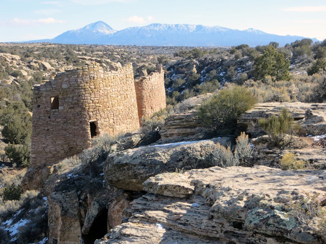
Round towers built on canyon edge, mountains in background
Hovenweep is a remote land of contrasts and harmony.

NPS/A.W. Biel

The Northern Colorado Plateau Network monitors climate, land surface phenology, landscape dynamics, springs and seeps, and water quality at Hovenweep National Monument. The results of that monitoring provide park managers with scientific information for decisionmaking.

Hovenweep National Monument was established by Presidential Proclamation in 1923, to preserve "groups of ruins, including prehistoric structures, the majority of which belong to unique types not found in other National Monuments, and show the finest prehistoric masonry in the United States." The monument is best known for protecting a collection of canyon-rim towers and villages that are the best preserved and protected, most visually striking, and most accessible examples of thirteenth-century Ancestral Puebloan architecture within the San Juan River Basin.

The monument comprises six distinct units. Elevation ranges from 1,585 meters (5,200 feet) at the Cajon unit to 2,060 meters (6,760 feet) at the Goodman Point unit. The climate in this high desert is dry, with an average of 305 millimeters (12 inches) of precipitation per year. Temperatures range from winter lows of -10 to 0°F to summer highs averaging 100–105°F, with a mean annual temperature of 52°F. The monument's shrubland types are influenced by precipitation, landscape position, soil depth, and alkalinity/salinity. Woodland associations are established on canyon sides, canyon rims, slopes, and hills. Herbaceous plant communities are a relatively minor component of the monument's vegetation, and riparian vegetation is rare. While permanent water sources are limited, a few springs and seeps in canyonheads produce water year-round.

Trespass livestock, exotic plant species invasion, adjacent land-use impacts, and increasing recreational use are the monument's main natural resource management concerns.

Quick Reads

Showing results 1-10 of 11

    • Locations: Arches National Park, Bryce Canyon National Park, Canyonlands National Park, Capitol Reef National Park, Dinosaur National Monument,
    • Offices: Inventory and Monitoring Division, Northern Colorado Plateau Inventory & Monitoring Network
    A calm river flows through a red rock canyon on a sunny summer day.

    Good, clean water is essential for healthy ecosystems--for people, vegetation, and animals--making it one of the most important resources in the semi-arid west. The Northern Colorado Plateau Network and its partners monitor water quality in 8 national parks in Utah and Colorado to help scientists and managers conserve these resources. This article summarizes 2019-2022 water quality data and how they compare to state standards.

    • Locations: Acadia National Park, Agate Fossil Beds National Monument, Alibates Flint Quarries National Monument, Amistad National Recreation Area, Antietam National Battlefield,
    • Offices: Appalachian Highlands Inventory & Monitoring Network, Chihuahuan Desert Inventory & Monitoring Network, Cumberland Piedmont Inventory & Monitoring Network, Eastern Rivers and Mountains Inventory & Monitoring Network, Great Lakes Inventory & Monitoring Network,
    Green, orange, and dead grey junipers in red soil, mountains in background

    Across the US, changes in water availability are altering which plants grow where. These changes are evident at a broad scale. But not all areas experience the same climate in the same way, even within the boundaries of a single national park. A new dataset gives park managers a valuable tool for understanding why vegetation has changed and how it might change in the future under different climate-change scenarios.

    • Locations: Hovenweep National Monument
    • Offices: Inventory and Monitoring Division, Natural Resource Stewardship and Science Directorate, Northern Colorado Plateau Inventory & Monitoring Network
    Ancestral structures in a canyon and on its rim

    Springs are naturally and culturally important at Hovenweep National Monument. Through long-term monitoring, the Northern Colorado Plateau Network is tracking the health of three spring systems across time here. Some sites are proving more resilient than others in the face of prolonged drought and rising temperatures. But there are actions park managers can take to help conserve these resources as the climate continues to change.

    • Locations: Arches National Park, Black Canyon Of The Gunnison National Park, Bryce Canyon National Park, Canyonlands National Park, Capitol Reef National Park,
    • Offices: Inventory and Monitoring Division, Northern Colorado Plateau Inventory & Monitoring Network
    Satellite and Earth in space

    Scientists from the Northern Colorado Plateau Network travel thousands of miles each year to collect data on plants, soils, and water across network parks. But it would be impossible to cover every square inch of the Northern Colorado Plateau with boots on the ground. Instead, we simultaneously monitor the parks with boots in space—satellite data that provide information at a much broader scale.

    • Locations: Arches National Park, Aztec Ruins National Monument, Bandelier National Monument, Bent's Old Fort National Historic Site, Big Bend National Park,
    • Offices: Chihuahuan Desert Inventory & Monitoring Network, Climate Change, Climate Change Response Program, Inventory and Monitoring Division, Mediterranean Coast Inventory & Monitoring Network,
    Dark storm clouds and rainbow over mountains and saguaros.

    When the climate changes enough, the vegetation communities growing in any given place will also change. Under an expanded bimodal climate zone, some plant communities in western national parks are more likely to change than others. National Park Service ecologists and partners investigated the future conditions that may force some of this change. Having this information can help park managers decide whether to resist, direct, or accept the change.

    • Locations: Alibates Flint Quarries National Monument, Amistad National Recreation Area, Arches National Park, Aztec Ruins National Monument, Bandelier National Monument,
    • Offices: Chihuahuan Desert Inventory & Monitoring Network, Greater Yellowstone Inventory & Monitoring Network, Inventory and Monitoring Division, Natural Resource Stewardship and Science Directorate, Northern Colorado Plateau Inventory & Monitoring Network,
    A man looks through binoculars at sunrise.

    Across the Intermountain Region, Inventory & Monitoring Division ecologists are helping to track the effects of climate change, provide baseline information for resource management, evaluate new technologies, and inspire the next generation of park stewards. This article highlights accomplishments achieved during fiscal year 2021.

    • Locations: Arches National Park, Bryce Canyon National Park, Canyonlands National Park, Capitol Reef National Park, Dinosaur National Monument,
    • Offices: Inventory and Monitoring Division, Northern Colorado Plateau Inventory & Monitoring Network
    Ripples in cave water

    Pesticides, antibiotics, and personal care products are all being found in streams and rivers. But would you expect to find them in a national park? On the northern Colorado Plateau, scientists found that even in isolated areas, these "contaminants of emerging concern" are not uncommon. Find out what we found where--and how you can help.

    • Locations: Arches National Park, Black Canyon Of The Gunnison National Park, Bryce Canyon National Park, Canyonlands National Park, Capitol Reef National Park,
    • Offices: Inventory and Monitoring Division, Northern Colorado Plateau Inventory & Monitoring Network
    Man stands in a stream, looking down at a handheld gauge.

    Knowing which key natural resources are found in the national parks, and whether they're stable or changing, helps decisionmakers make sound choices. The Northern Colorado Plateau Network is building that knowledge. After more than ten years of monitoring, we've learned a lot about park ecosystems, how they're changing, and what they may look like in the days to come. Find out what we’ve learned and how it’s being used to help managers plan for the future.

    • Locations: Arches National Park, Black Canyon Of The Gunnison National Park, Bryce Canyon National Park, Canyonlands National Park, Capitol Reef National Park,
    A monitoring crew of three samples a clear river flowing over brown rock and sand

    Once a month, ecologists collect water samples at dozens of monitoring sites in and near ten National Park Service units across Utah and Colorado. This consistent, long-term monitoring helps alert managers to existing and potential problems. Find out the results for 2016-2018 in this brief from the Northern Colorado Plateau Network.

    • Locations: Arches National Park, Canyonlands National Park, Hovenweep National Monument, Natural Bridges National Monument, Yellowstone National Park, Yosemite National Park
    Pika with a mouthful of grass

    In response to climate change, park managers are having to rethink how they plan for the future. Climate Smart Conservation is a process that can help managers achieve goals in the face of coming changes. Under this framework, scientists and managers use their collective knowledge to anticipate problems and be proactive, rather than reactive.

Publications

Source: Data Store Saved Search 3779. To search for additional information, visit the Data Store.

Source: Data Store Saved Search 3780. To search for additional information, visit the Data Store.

Last updated: October 31, 2020