Natural Resources Monitoring at Curecanti National Recreation Area

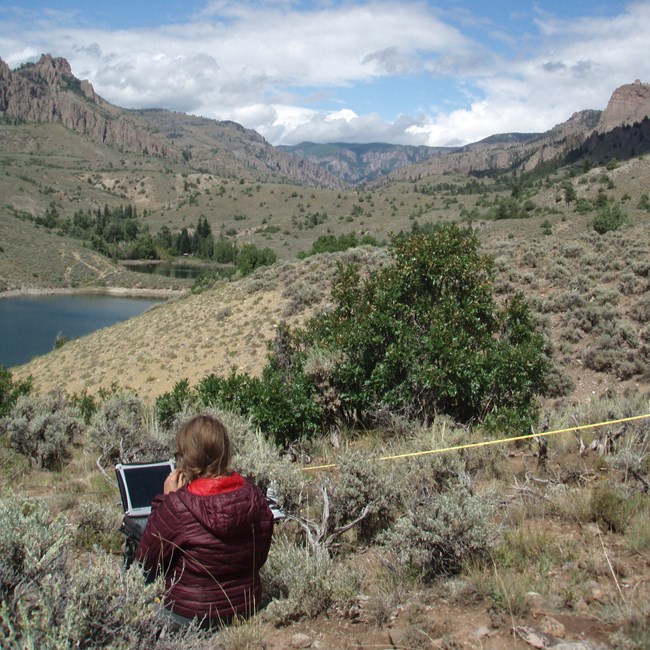
Person uses a field laptop next to transect tape above a lake
Terrestrial vegetation and soils are a key  focus of monitoring at Curecanti National Recreation Area.

NPS

The Northern Colorado Plateau Network monitors air quality, big rivers, climate, invasive exotic plants, land surface phenology, landbirds, landscape dynamics, uplands, and water quality at Curecanti National Recreation Area. The results of that monitoring provide park managers with scientific information for decisionmaking.

Curecanti National Recreation Area became part of the National Park System on February 11, 1965. The recreation area is composed of a chain of three reservoirs impounded on the Gunnison River. The park's purpose is to "operate and maintain public recreational facilities" on its lands, "conserve the scenery, the natural, historic, and archeological objects, and the wildlife on said lands," and "mitigate losses of, and improve conditions for, the propagation of fish and wildlife."

Elevations ranging from 1,981 meters (6,500 feet) at East Portal to 2,896 meters (9,500 feet) near Sheep Knob, in combination with slope, geology, and aspect, have created diverse habitats that support a wide variety of vertebrate and plant species. Temperatures range from lows of -30°F (-34°C) to highs of approximately 85°F (29°C). Average annual precipitation is approximately 280 millimeters (11 inches). Most precipitation occurs in spring and summer rains. Shrublands occupy a large area of the park. The shoreline slopes surrounding Blue Mesa Reservoir are covered with grasses, big sagebrush, rabbitbrush, and Gambel oak. The mesa tops are characteristically covered with high-desert vegetation with intermittent pockets of Douglas-fir, quaking aspen, and spruce. The eastern-most portion of the park consists of a riverine system, essentially unaltered since reservoir construction.

Livestock grazing, exotic plant and animal invasion, adjacent land-use impacts, increasing recreational use, the altered hydrologic regime, and a lack of basic natural-resource data are the main natural resource management concerns.

Quick Reads

Showing results 1-10 of 19

    • Locations: Black Canyon Of The Gunnison National Park, Curecanti National Recreation Area
    • Offices: Inventory and Monitoring Division, Natural Resource Stewardship and Science Directorate, Northern Colorado Plateau Inventory & Monitoring Network
    Two field crew members measure vegetation in a dry, grassy landscape.

    At Black Canyon of the Gunnison National Park and Curecanti National Recreation Area, long-term vegetation monitoring provides park managers with useful information for decision making on topics including changes in climate, grazing, and fire management. A recent report summarizes monitoring from 2011 to 2022 of vegetation and soil conditions provides management recommendations for their conservation.

    • Locations: Curecanti National Recreation Area
    • Offices: Inventory and Monitoring Division, Natural Resource Stewardship and Science Directorate, Northern Colorado Plateau Inventory & Monitoring Network
    Oxeye daisies partially along the shoreline of Blue Mesa Reservoir in Curecanti NRA.

    Invasive exotic plants are one of the most significant threats to natural resources in the national parks today. To provide early warning of weed invasions, the Northern Colorado Plateau Network monitors target plants in park areas where they are likely to first establish: along roads, trails, and waterways. Find out what we've learned at Curecanti National Recreation Area.

    • Locations: Arches National Park, Black Canyon Of The Gunnison National Park, Bryce Canyon National Park, Canyonlands National Park, Capitol Reef National Park,
    • Offices: Inventory and Monitoring Division, Northern Colorado Plateau Inventory & Monitoring Network
    A bird sitting in a tree.

    Northern Colorado Plateau Network’s long-term landbird monitoring program provides habitat-based updates for bird population status and trends in the parks in the Northern Colorado Plateau. These inform scientists and managers about changes in bird populations and about the health of the habitats they depend on. Learn more about which species were detected in the network parks for the first time and which landbird populations were increasing or declining between 2005 - 2024.

    • Locations: Acadia National Park, Agate Fossil Beds National Monument, Alibates Flint Quarries National Monument, Amistad National Recreation Area, Antietam National Battlefield,
    • Offices: Appalachian Highlands Inventory & Monitoring Network, Chihuahuan Desert Inventory & Monitoring Network, Cumberland Piedmont Inventory & Monitoring Network, Eastern Rivers and Mountains Inventory & Monitoring Network, Great Lakes Inventory & Monitoring Network,
    Green, orange, and dead grey junipers in red soil, mountains in background

    Across the US, changes in water availability are altering which plants grow where. These changes are evident at a broad scale. But not all areas experience the same climate in the same way, even within the boundaries of a single national park. A new dataset gives park managers a valuable tool for understanding why vegetation has changed and how it might change in the future under different climate-change scenarios.

    • Locations: Arches National Park, Black Canyon Of The Gunnison National Park, Bryce Canyon National Park, Canyonlands National Park, Capitol Reef National Park,
    • Offices: Inventory and Monitoring Division, Natural Resource Stewardship and Science Directorate, Northern Colorado Plateau Inventory & Monitoring Network
    A speckled white bird floats on blue water.

    Because birds can be sensitive to habitat change, they are good indicators of ecosystem integrity. The Northern Colorado Plateau Network partners with the University of Delaware to assess breeding-bird species trends in three different habitats: low-elevation riparian, pinyon-juniper, and sage shrubland. Find out which species were increasing and declining at network parks as of 2023.

    • Locations: Arches National Park, Black Canyon Of The Gunnison National Park, Bryce Canyon National Park, Canyonlands National Park, Capitol Reef National Park,
    • Offices: Inventory and Monitoring Division, Northern Colorado Plateau Inventory & Monitoring Network
    A man wearing a clipboard looks through binoculars at dawn in field of sagebrush

    Birds of the desert southwest, a climate-change hotspot, are among the most vulnerable groups in the US. To help park managers plan for those changes, scientists evaluated the influence of water deficit on landbird communities at 11 national parks in Utah and Colorado. The results will help land managers to focus conservation efforts on places where certain species are most vulnerable to projected climate changes.

    • Locations: Arches National Park, Black Canyon Of The Gunnison National Park, Bryce Canyon National Park, Canyonlands National Park, Capitol Reef National Park,
    • Offices: Inventory and Monitoring Division, Northern Colorado Plateau Inventory & Monitoring Network
    Satellite and Earth in space

    Scientists from the Northern Colorado Plateau Network travel thousands of miles each year to collect data on plants, soils, and water across network parks. But it would be impossible to cover every square inch of the Northern Colorado Plateau with boots on the ground. Instead, we simultaneously monitor the parks with boots in space—satellite data that provide information at a much broader scale.

    • Locations: Arches National Park, Aztec Ruins National Monument, Bandelier National Monument, Bent's Old Fort National Historic Site, Big Bend National Park,
    • Offices: Chihuahuan Desert Inventory & Monitoring Network, Climate Change, Climate Change Response Program, Inventory and Monitoring Division, Mediterranean Coast Inventory & Monitoring Network,
    Dark storm clouds and rainbow over mountains and saguaros.

    When the climate changes enough, the vegetation communities growing in any given place will also change. Under an expanded bimodal climate zone, some plant communities in western national parks are more likely to change than others. National Park Service ecologists and partners investigated the future conditions that may force some of this change. Having this information can help park managers decide whether to resist, direct, or accept the change.

    • Locations: Arches National Park, Black Canyon Of The Gunnison National Park, Bryce Canyon National Park, Canyonlands National Park, Capitol Reef National Park,
    • Offices: Inventory and Monitoring Division, Natural Resource Stewardship and Science Directorate, Northern Colorado Plateau Inventory & Monitoring Network
    Hairy woodpecker clings to the underside of a tree branch.

    Because birds can be sensitive to habitat change, they are good indicators of ecosystem integrity. The Northern Colorado Plateau Network partners with the University of Delaware to assess breeding-bird species trends in three different habitats: low-elevation riparian, pinyon-juniper, and sage shrubland. Find out which species were increasing and declining at network parks as of 2022.

    • Locations: Arches National Park, Black Canyon Of The Gunnison National Park, Bryce Canyon National Park, Canyonlands National Park, Capitol Reef National Park,
    • Offices: Inventory and Monitoring Division, Natural Resource Stewardship and Science Directorate, Northern Colorado Plateau Inventory & Monitoring Network
    Small dove with black spots on back of wings, long tail, and brownish-gray body.

    Because birds can be sensitive to habitat change, they are good indicators of ecosystem integrity. The Northern Colorado Plateau Network partners with the University of Delaware to assess breeding-bird species trends in three different habitats: low-elevation riparian, pinyon-juniper, and sage shrubland. Find out which species were increasing and declining at network parks as of 2021.

Publications

Source: Data Store Saved Search 3772. To search for additional information, visit the Data Store.

Source: Data Store Saved Search 3771. To search for additional information, visit the Data Store.

Last updated: October 31, 2020