NPS
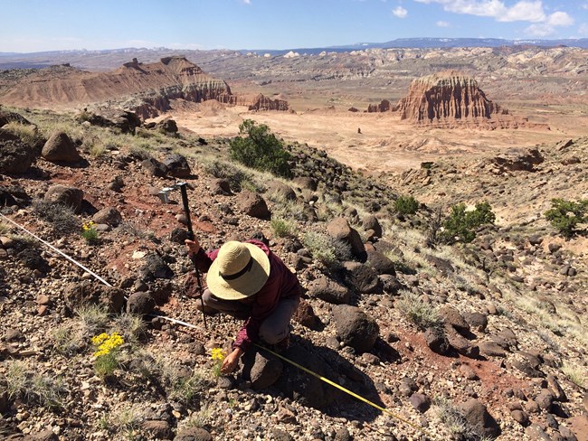
Uplands are land areas lying above the elevation where flooding generally occurs—areas found beyond riparian zones. Uplands represent the vast majority of land area in the Northern Colorado Plateau Network (NCPN), and include rock outcrops, badlands, shrublands, grasslands, woodlands, and forests. Upland vegetation provides energy to other trophic levels, habitat structure for various organisms, and is a significant component of species diversity. The ability of uplands to retain soil and nutrients, absorb and release water, and buffer high-runoff precipitation events is a major influence on riparian condition.
Upland ecosystems are easily disturbed and slow to recover, yet several NCPN units contain relatively undisturbed examples of grasslands and shrublands. Historic land uses include livestock and timber production; more recently, recreational use has increased. To effectively manage uplands, the National Park Service needs to know the impacts of these uses.
Uplands monitoring includes measuring soil stability, hydrologic function, biological soil crusts, and plant community characteristics. The NCPN uses a complex survey design to select randomized sampling plots that are visited in two consecutive years, followed by a relatively long interval between revisits (3–6 years). This design minimizes the chances that sensitive, arid-ecosystem plots will be damaged by repeated visits in successive years and is a cost-effective way to estimate the health of upland ecosystems across a large area. NCPN uplands monitoring is intended to strike a balance between increasing fundamental understanding of these systems and providing managers with early warning of undesirable change.
The Northern Colorado Plateau Network monitors upland vegetation and soils at Arches National Park, Black Canyon of the Gunnison National Park, Bryce Canyon National Park, Canyonlands National Park, Capitol Reef National Park, Cedar Breaks National Monument, Curecanti National Recreation Area, Dinosaur National Monument, Timpanogos Cave National Monument, and Zion National Park.
Vital Signs: Native grasslands, shrublands, predominant plant communities, upland nutrient cycle, biological soil crusts, upland hydrologic function, upland soil/site stability
Protocol Lead: Carolyn Livensperger
Plants of the Northern Colorad...
Selected plants recorded by Northern Colorado Plateau Network ecologists, who conduct long-term monitoring of vegetation and soils in 10 national parks across Colorado and Utah.
Quick Reads
- Locations: Acadia National Park, Agate Fossil Beds National Monument, Alibates Flint Quarries National Monument, Amistad National Recreation Area, Antietam National Battlefield, more »
- Offices: Appalachian Highlands Inventory & Monitoring Network, Chihuahuan Desert Inventory & Monitoring Network, Cumberland Piedmont Inventory & Monitoring Network, Eastern Rivers and Mountains Inventory & Monitoring Network, Great Lakes Inventory & Monitoring Network, more »
Across the US, changes in water availability are altering which plants grow where. These changes are evident at a broad scale. But not all areas experience the same climate in the same way, even within the boundaries of a single national park. A new dataset gives park managers a valuable tool for understanding why vegetation has changed and how it might change in the future under different climate-change scenarios.
- Locations: Dinosaur National Monument
- Offices: Inventory and Monitoring Division, Natural Resource Stewardship and Science Directorate, Northern Colorado Plateau Inventory & Monitoring Network
At Dinosaur National Monument, long-term vegetation monitoring provides park managers with useful information for decisionmaking on topics including climate change, grazing, and fire management. A recent report summarizes 10 years of monitoring in sagebrush and pinyon-juniper communities and provides management recommendations for their conservation.
- Locations: Arches National Park, Black Canyon Of The Gunnison National Park, Bryce Canyon National Park, Canyonlands National Park, Capitol Reef National Park, more »
- Offices: Inventory and Monitoring Division, Northern Colorado Plateau Inventory & Monitoring Network
Scientists from the Northern Colorado Plateau Network travel thousands of miles each year to collect data on plants, soils, and water across network parks. But it would be impossible to cover every square inch of the Northern Colorado Plateau with boots on the ground. Instead, we simultaneously monitor the parks with boots in space—satellite data that provide information at a much broader scale.
- Locations: Capitol Reef National Park
- Offices: Inventory and Monitoring Division, Northern Colorado Plateau Inventory & Monitoring Network
At Capitol Reef National Park, long-term monitoring is helping track grassland condition and recovery from grazing. From 2009 to 2018, there was some evidence of continued recovery of vegetation and soils in the park’s retired Cathedral/Rock Springs allotments. Continued monitoring will be crucial to providing managers with the information they need for effective decisionmaking and resource allocation.
- Locations: Arches National Park, Canyonlands National Park, Capitol Reef National Park, Curecanti National Recreation Area, Dinosaur National Monument
- Offices: Inventory and Monitoring Division, Northern Colorado Plateau Inventory & Monitoring Network
The results of a recent study may help land managers to prioritize grassland conservation and restoration efforts. Park managers can’t do much about climate, but with the right information, they can make choices based on how different grassland communities behave in different soil types. In this study, cool-season grasses showed more resilience to drought than warm-season grasses.
- Locations: Arches National Park, Black Canyon Of The Gunnison National Park, Bryce Canyon National Park, Canyonlands National Park, Capitol Reef National Park, more »
- Offices: Inventory and Monitoring Division, Northern Colorado Plateau Inventory & Monitoring Network
Knowing which key natural resources are found in the national parks, and whether they're stable or changing, helps decisionmakers make sound choices. The Northern Colorado Plateau Network is building that knowledge. After more than ten years of monitoring, we've learned a lot about park ecosystems, how they're changing, and what they may look like in the days to come. Find out what we’ve learned and how it’s being used to help managers plan for the future.
- Locations: Capitol Reef National Park, Little Bighorn Battlefield National Monument, Organ Pipe Cactus National Monument
Long-term environmental monitoring usually requires complex sampling designs. By necessity, these designs sample a limited set of conditions on just a fraction of the landscape, which results in missing data. This article summarizes recent research that applies Bayesian modeling to three case studies in national parks. This approach allows park ecologists and analysts to move beyond missing data to support data-driven management and monitoring of natural resources.
- Locations: Arches National Park, Black Canyon Of The Gunnison National Park, Canyonlands National Park, Capitol Reef National Park, Curecanti National Recreation Area, more »
As the northern Colorado Plateau heads into a hotter, drier future, there will be ecological winners and losers. Figuring out how different vegetation communities will fare is tricky. A recent study aimed to identify which vegetation communities might come out ahead, which might lag behind, and what might make the difference.
- Capitol Reef National Park
Short-term Forecasting of Vegetation Condition: Potential Management Uses
- Locations: Capitol Reef National Park
If strong, site-specific relationships between various climate and environmental factors can be developed at management scales, then it should be possible to make near-term forecasts of vegetation condition by tracking weather and water balance. Park managers could use this model to help predict the months and years in which projects that depend on good growing conditions, such as restoration activities, might be most likely to succeed.
Publications and Other Information
Source: Data Store Saved Search 478. To search for additional information, visit the Data Store.
Source: Data Store Saved Search 455. To search for additional information, visit the Data Store.
Source: Data Store Collection 3870. To search for additional information, visit the Data Store.
Source: Data Store Saved Search 538. To search for additional information, visit the Data Store.
Last updated: March 1, 2022