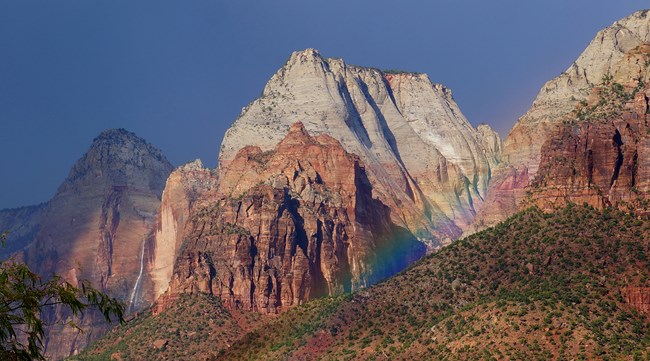
NPS/A. Washuta
The Northern Colorado Plateau Network monitors air quality, climate, invasive exotic plants, land surface phenology, landbirds, landscape dynamics, uplands, wadeable streams, and water quality at Zion National Park. The results of that monitoring provide park managers with scientific information for decisionmaking.
Before it became a national park in 1919, Zion National Park was established as Mukuntuweap National Monument by Presidential Proclamation on July 31, 1909. The national park status was proffered to protect "unusual archeological, geologic and geographic interests." The park is best known for its labyrinth of remarkable canyons, volcanic phenomena, fossiliferous deposits, brilliantly colored strata, and rare sedimentation. Due to downcutting of the Virgin River, Zion Canyon provides a spectacular display of Triassic and Jurassic sediments, the most spectacular of which is a 2,000-foot thick exposure of Navajo sandstone.
Elevation ranges from 1,128 meters (3,700 feet) in the park's southwestern corner to 2,660 meters (8,726 feet) on Horse Ranch Mountain in the northeast. Elevational differences influence the park's vegetation communities. Desert and semi-desert shrublands dominated by blackbrush, big sagebrush, fourwing saltbush, rabbitbrush, greasewood, snakeweed, and Mormon tea predominate at lower elevations. Mid-elevation vegetation is often dominated by pinyon-juniper woodlands, with woodland understories dominated by Utah serviceberry, greenleaf manzanita, big sagebrush, mountain mahogany, curl-leaf mountain-mahogany, Stansbury cliffrose, turbinella live oak, or Gambel oak. Higher-elevation vegetation is characterized by montane vegetation types, such as ponderosa pine woodland and forest, quaking aspen forest, Douglas-fir forest, white fir forests, and mixed montane shrublands and grasslands. Water resources include springs, seeps, tinajas, and the Virgin River and its tributaries.
Increasing recreational use, adjacent land-use impacts, exotic plant species invasion, and degradation of riparian areas are the park's main natural resource management concerns.
Quick Reads
- Locations: Arches National Park, Black Canyon Of The Gunnison National Park, Bryce Canyon National Park, Canyonlands National Park, Capitol Reef National Park, more »
- Offices: Inventory and Monitoring Division, Northern Colorado Plateau Inventory & Monitoring Network
Northern Colorado Plateau Network’s long-term landbird monitoring program provides habitat-based updates for bird population status and trends in the parks in the Northern Colorado Plateau. These inform scientists and managers about changes in bird populations and about the health of the habitats they depend on. Learn more about which species were detected in the network parks for the first time and which landbird populations were increasing or declining between 2005 - 2024.
- Locations: Arches National Park, Bryce Canyon National Park, Canyonlands National Park, Capitol Reef National Park, Dinosaur National Monument, more »
- Offices: Inventory and Monitoring Division, Northern Colorado Plateau Inventory & Monitoring Network
Good, clean water is essential for healthy ecosystems--for people, vegetation, and animals--making it one of the most important resources in the semi-arid west. The Northern Colorado Plateau Network and its partners monitor water quality in 8 national parks in Utah and Colorado to help scientists and managers conserve these resources. This article summarizes 2019-2022 water quality data and how they compare to state standards.
- Locations: Acadia National Park, Agate Fossil Beds National Monument, Alibates Flint Quarries National Monument, Amistad National Recreation Area, Antietam National Battlefield, more »
- Offices: Appalachian Highlands Inventory & Monitoring Network, Chihuahuan Desert Inventory & Monitoring Network, Cumberland Piedmont Inventory & Monitoring Network, Eastern Rivers and Mountains Inventory & Monitoring Network, Great Lakes Inventory & Monitoring Network, more »
Across the US, changes in water availability are altering which plants grow where. These changes are evident at a broad scale. But not all areas experience the same climate in the same way, even within the boundaries of a single national park. A new dataset gives park managers a valuable tool for understanding why vegetation has changed and how it might change in the future under different climate-change scenarios.
- Locations: Arches National Park, Black Canyon Of The Gunnison National Park, Bryce Canyon National Park, Canyonlands National Park, Capitol Reef National Park, more »
- Offices: Inventory and Monitoring Division, Natural Resource Stewardship and Science Directorate, Northern Colorado Plateau Inventory & Monitoring Network
Because birds can be sensitive to habitat change, they are good indicators of ecosystem integrity. The Northern Colorado Plateau Network partners with the University of Delaware to assess breeding-bird species trends in three different habitats: low-elevation riparian, pinyon-juniper, and sage shrubland. Find out which species were increasing and declining at network parks as of 2023.
- Locations: Arches National Park, Black Canyon Of The Gunnison National Park, Bryce Canyon National Park, Canyonlands National Park, Capitol Reef National Park, more »
- Offices: Inventory and Monitoring Division, Northern Colorado Plateau Inventory & Monitoring Network
Birds of the desert southwest, a climate-change hotspot, are among the most vulnerable groups in the US. To help park managers plan for those changes, scientists evaluated the influence of water deficit on landbird communities at 11 national parks in Utah and Colorado. The results will help land managers to focus conservation efforts on places where certain species are most vulnerable to projected climate changes.
- Locations: Arches National Park, Black Canyon Of The Gunnison National Park, Bryce Canyon National Park, Canyonlands National Park, Capitol Reef National Park, more »
- Offices: Inventory and Monitoring Division, Northern Colorado Plateau Inventory & Monitoring Network
Scientists from the Northern Colorado Plateau Network travel thousands of miles each year to collect data on plants, soils, and water across network parks. But it would be impossible to cover every square inch of the Northern Colorado Plateau with boots on the ground. Instead, we simultaneously monitor the parks with boots in space—satellite data that provide information at a much broader scale.
- Locations: Arches National Park, Aztec Ruins National Monument, Bandelier National Monument, Bent's Old Fort National Historic Site, Big Bend National Park, more »
- Offices: Chihuahuan Desert Inventory & Monitoring Network, Climate Change, Climate Change Response Program, Inventory and Monitoring Division, Mediterranean Coast Inventory & Monitoring Network, more »
When the climate changes enough, the vegetation communities growing in any given place will also change. Under an expanded bimodal climate zone, some plant communities in western national parks are more likely to change than others. National Park Service ecologists and partners investigated the future conditions that may force some of this change. Having this information can help park managers decide whether to resist, direct, or accept the change.
- Locations: Arches National Park, Black Canyon Of The Gunnison National Park, Bryce Canyon National Park, Canyonlands National Park, Capitol Reef National Park, more »
- Offices: Inventory and Monitoring Division, Natural Resource Stewardship and Science Directorate, Northern Colorado Plateau Inventory & Monitoring Network
Because birds can be sensitive to habitat change, they are good indicators of ecosystem integrity. The Northern Colorado Plateau Network partners with the University of Delaware to assess breeding-bird species trends in three different habitats: low-elevation riparian, pinyon-juniper, and sage shrubland. Find out which species were increasing and declining at network parks as of 2022.
- Locations: Arches National Park, Black Canyon Of The Gunnison National Park, Bryce Canyon National Park, Canyonlands National Park, Capitol Reef National Park, more »
- Offices: Inventory and Monitoring Division, Natural Resource Stewardship and Science Directorate, Northern Colorado Plateau Inventory & Monitoring Network
Because birds can be sensitive to habitat change, they are good indicators of ecosystem integrity. The Northern Colorado Plateau Network partners with the University of Delaware to assess breeding-bird species trends in three different habitats: low-elevation riparian, pinyon-juniper, and sage shrubland. Find out which species were increasing and declining at network parks as of 2021.
- Locations: Alibates Flint Quarries National Monument, Amistad National Recreation Area, Arches National Park, Aztec Ruins National Monument, Bandelier National Monument, more »
- Offices: Chihuahuan Desert Inventory & Monitoring Network, Greater Yellowstone Inventory & Monitoring Network, Inventory and Monitoring Division, Natural Resource Stewardship and Science Directorate, Northern Colorado Plateau Inventory & Monitoring Network, more »
Across the Intermountain Region, Inventory & Monitoring Division ecologists are helping to track the effects of climate change, provide baseline information for resource management, evaluate new technologies, and inspire the next generation of park stewards. This article highlights accomplishments achieved during fiscal year 2021.
Publications
Source: Data Store Saved Search 3755. To search for additional information, visit the Data Store.
Source: Data Store Saved Search 3756. To search for additional information, visit the Data Store.
Last updated: February 3, 2022