Natural Resources Monitoring at Colorado National Monument

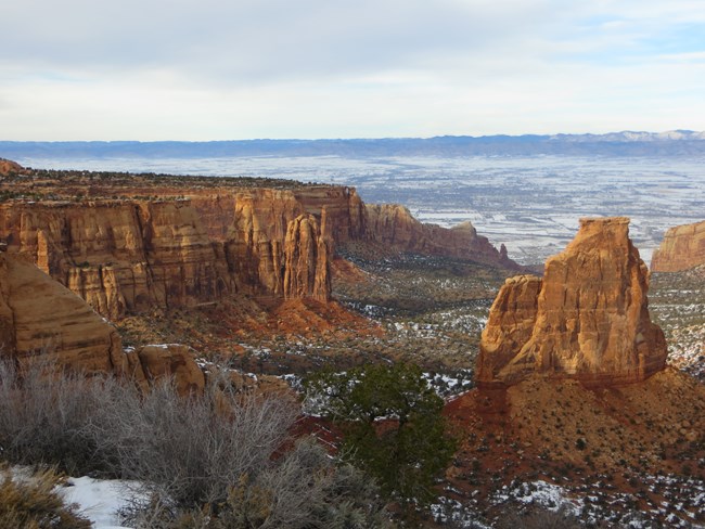
Red rock canyons with open, flat landscape beyond
The eroded landscapes of Colorado National Monument tower over Grand Junction, Colorado.

NPS/A.W. Biel

The Northern Colorado Plateau Network monitors air quality, climate, invasive exotic plants, land surface phenology, landbirds, and landscape dynamics at Colorado National Monument. The results of that monitoring provide park managers with scientific information for decisionmaking.

Colorado National Monument was established by Presidential Proclamation on May 24, 1911, to reserve in the public interest "the extraordinary examples of erosion (which) are of great scientific interest." The monument is best known for its outstanding geologic features, exposed and sculpted by erosion. Geologic history, from the ancient crystalline rocks of the Precambrian age to the soft, mixed shales and sandstones of the Jurassic age Morrison formation, is recorded in the exposed cliffs.

Elevation ranges from 1,408 meters (4,620 feet) at the foot of the cliffs to 2,166 meters (7,107 feet) on the mesa above the canyons. A semi-desert upland climate prevails, with an average of less than 280 millimeters (11 inches) annual precipitation. Temperatures range from summer highs in the high 90s (F) to winter lows in the sub-zero range. Snowfall averages 96 centimeters (38 inches).

Woodlands and shrublands types are the monument's most diverse plant communities; both occupy all habitats. Forest and graminoid communities are uncommon, and forb and non-vascular plant communities are rare. There are no perennial streams in the monument, but there are ephemeral surface flows, seeps, and potholes that supply water for wildlife throughout most of the year.

Increasing recreational use, adjacent land-use impacts, exotic plant species invasion, native plant mortality, fire-fuel loading, and a lack of data related to monument fauna are the park's main natural resource management concerns.

Quick Reads

Showing results 1-10 of 15

    • Locations: Arches National Park, Black Canyon Of The Gunnison National Park, Bryce Canyon National Park, Canyonlands National Park, Capitol Reef National Park,
    • Offices: Inventory and Monitoring Division, Northern Colorado Plateau Inventory & Monitoring Network
    A bird sitting in a tree.

    Northern Colorado Plateau Network’s long-term landbird monitoring program provides habitat-based updates for bird population status and trends in the parks in the Northern Colorado Plateau. These inform scientists and managers about changes in bird populations and about the health of the habitats they depend on. Learn more about which species were detected in the network parks for the first time and which landbird populations were increasing or declining between 2005 - 2024.

    • Locations: Acadia National Park, Agate Fossil Beds National Monument, Alibates Flint Quarries National Monument, Amistad National Recreation Area, Antietam National Battlefield,
    • Offices: Appalachian Highlands Inventory & Monitoring Network, Chihuahuan Desert Inventory & Monitoring Network, Cumberland Piedmont Inventory & Monitoring Network, Eastern Rivers and Mountains Inventory & Monitoring Network, Great Lakes Inventory & Monitoring Network,
    Green, orange, and dead grey junipers in red soil, mountains in background

    Across the US, changes in water availability are altering which plants grow where. These changes are evident at a broad scale. But not all areas experience the same climate in the same way, even within the boundaries of a single national park. A new dataset gives park managers a valuable tool for understanding why vegetation has changed and how it might change in the future under different climate-change scenarios.

    • Locations: Arches National Park, Black Canyon Of The Gunnison National Park, Bryce Canyon National Park, Canyonlands National Park, Capitol Reef National Park,
    • Offices: Inventory and Monitoring Division, Northern Colorado Plateau Inventory & Monitoring Network
    A man wearing a clipboard looks through binoculars at dawn in field of sagebrush

    Birds of the desert southwest, a climate-change hotspot, are among the most vulnerable groups in the US. To help park managers plan for those changes, scientists evaluated the influence of water deficit on landbird communities at 11 national parks in Utah and Colorado. The results will help land managers to focus conservation efforts on places where certain species are most vulnerable to projected climate changes.

    • Locations: Arches National Park, Black Canyon Of The Gunnison National Park, Bryce Canyon National Park, Canyonlands National Park, Capitol Reef National Park,
    • Offices: Inventory and Monitoring Division, Northern Colorado Plateau Inventory & Monitoring Network
    Satellite and Earth in space

    Scientists from the Northern Colorado Plateau Network travel thousands of miles each year to collect data on plants, soils, and water across network parks. But it would be impossible to cover every square inch of the Northern Colorado Plateau with boots on the ground. Instead, we simultaneously monitor the parks with boots in space—satellite data that provide information at a much broader scale.

    • Locations: Arches National Park, Aztec Ruins National Monument, Bandelier National Monument, Bent's Old Fort National Historic Site, Big Bend National Park,
    • Offices: Chihuahuan Desert Inventory & Monitoring Network, Climate Change, Climate Change Response Program, Inventory and Monitoring Division, Mediterranean Coast Inventory & Monitoring Network,
    Dark storm clouds and rainbow over mountains and saguaros.

    When the climate changes enough, the vegetation communities growing in any given place will also change. Under an expanded bimodal climate zone, some plant communities in western national parks are more likely to change than others. National Park Service ecologists and partners investigated the future conditions that may force some of this change. Having this information can help park managers decide whether to resist, direct, or accept the change.

    • Locations: Arches National Park, Black Canyon Of The Gunnison National Park, Bryce Canyon National Park, Canyonlands National Park, Capitol Reef National Park,
    • Offices: Inventory and Monitoring Division, Natural Resource Stewardship and Science Directorate, Northern Colorado Plateau Inventory & Monitoring Network
    Hairy woodpecker clings to the underside of a tree branch.

    Because birds can be sensitive to habitat change, they are good indicators of ecosystem integrity. The Northern Colorado Plateau Network partners with the University of Delaware to assess breeding-bird species trends in three different habitats: low-elevation riparian, pinyon-juniper, and sage shrubland. Find out which species were increasing and declining at network parks as of 2022.

    • Locations: Arches National Park, Black Canyon Of The Gunnison National Park, Bryce Canyon National Park, Canyonlands National Park, Capitol Reef National Park,
    • Offices: Inventory and Monitoring Division, Natural Resource Stewardship and Science Directorate, Northern Colorado Plateau Inventory & Monitoring Network
    Small dove with black spots on back of wings, long tail, and brownish-gray body.

    Because birds can be sensitive to habitat change, they are good indicators of ecosystem integrity. The Northern Colorado Plateau Network partners with the University of Delaware to assess breeding-bird species trends in three different habitats: low-elevation riparian, pinyon-juniper, and sage shrubland. Find out which species were increasing and declining at network parks as of 2021.

    • Locations: Alibates Flint Quarries National Monument, Amistad National Recreation Area, Arches National Park, Aztec Ruins National Monument, Bandelier National Monument,
    • Offices: Chihuahuan Desert Inventory & Monitoring Network, Greater Yellowstone Inventory & Monitoring Network, Inventory and Monitoring Division, Natural Resource Stewardship and Science Directorate, Northern Colorado Plateau Inventory & Monitoring Network,
    A man looks through binoculars at sunrise.

    Across the Intermountain Region, Inventory & Monitoring Division ecologists are helping to track the effects of climate change, provide baseline information for resource management, evaluate new technologies, and inspire the next generation of park stewards. This article highlights accomplishments achieved during fiscal year 2021.

    • Locations: Arches National Park, Black Canyon Of The Gunnison National Park, Bryce Canyon National Park, Canyonlands National Park, Capitol Reef National Park,
    • Offices: Northern Colorado Plateau Inventory & Monitoring Network
    Small beige bird with black beak and feet, brown back.

    Because birds can be sensitive to habitat change, they are good indicators of ecosystem integrity. The Northern Colorado Plateau Network partners with the University of Delaware to assess breeding-bird species trends in three different habitats: low-elevation riparian, pinyon-juniper, and sage shrubland. Find out which species were increasing and declining at network parks as of 2020.

    • Locations: Colorado National Monument
    • Offices: Inventory and Monitoring Division, Natural Resource Stewardship and Science Directorate, Northern Colorado Plateau Inventory & Monitoring Network
    Topo map with colored dots representing location and size of invasive exotic plant patches.

    Invasive exotic plants are one of the most significant threats to natural resources in the national parks today. To provide early warning of weed invasions, the Northern Colorado Plateau Network monitors target plants in park areas where they are likely to first establish: along roads, trails, and waterways. Find out what we've learned at Colorado National Monument.

Publications

Source: Data Store Saved Search 3769. To search for additional information, visit the Data Store.

Source: Data Store Saved Search 3770. To search for additional information, visit the Data Store.

Last updated: October 31, 2020