In keeping with the county-wide burn ban enacted on January 15 and extended on April 9, fires--including charcoal fires--are not permitted within Amistad National Recreation Area. To read the Val Verde County Commissioners Court Order, click "More". More
Park Closures
Diablo East Marina Cove, Scuba Cove, and Walkway Access Are Closed
The Diablo East Marina Cove, Scuba Cove, and walkway access are closed because of the presence of excessive docking material, unsafe walkway and dock, and unstable, loose ground. The area will reopen once these hazards have been corrected.
Only Left Side of Diablo East and Rough Canyon Boat Ramps Are Open - Rest Are Closed
Due to low water levels, only the left side of Diablo East and Rough Canyon boat ramps are open. Please use caution with Spur 406 and Spur 454 launches, as the water may be too shallow to launch most boats. To see a list of open ramps, click on "more." More
Due to the recent illegal lighting of a fire in the trash bin, the theft of government signs, and the unauthorized movement of barricades to drive into an area closed to vehicle traffic, the metal gate at the upper end of Box Canyon has now been closed.
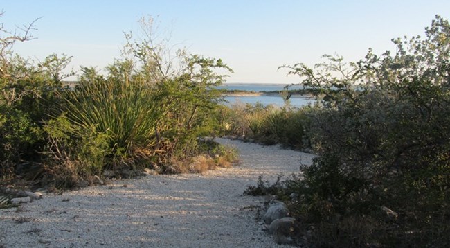
Whether looking to just stretch your legs with a short stroll or to take a longer hike, Amistad National Recreation Area offers hikers a number of easy trails to explore. At the Pecos Day Use Area, there is a short interpretive nature trail where you can enjoy views of the Pecos River, its cliffs, and a wide variety of plants. Read on to learn about safety considerations while hiking. More trails with maps are available at the bottom of the page.
Hiking Safety Tips
Always carry enough water (1 gallon per person per day).
Hike during cooler hours of the day.
Always use sunscreen and wear protective clothing.
The landscape is full of plants with thorns; wear pants and heavy-soled hiking boots.
Watch out for venomous snakes. The best way to do this is to not put body parts into areas you can't see into (tall grass, mounds of rocks, etc). If you encounter a snake, do not make any sudden movements. Stop, then slowly back away from it. Do not kill the snake. Snakes are protected by federal law and play a very important part in the desert ecosystem.
If you plan to hike alone, always let somebody know where you are going and when you will return.
Take only pictures; leave only footprints. All things inside National Park Service boundaries, living and non-living, are protected by federal law. The removal of plants, animals, artifacts, rocks, etc., is prohibited.
Bring a copy of Amistad National Recreation Area's hiking maps, which show the park's boundaries, since hiking on adjacent private land is not permitted.
For additional safety considerations, visit the park's Safety page.
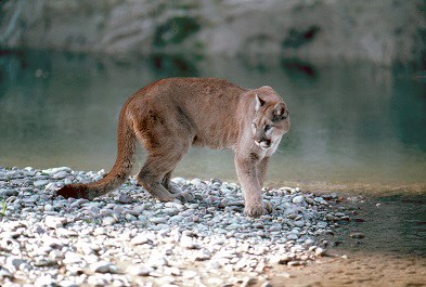
The most recognizable feature of a mountain lion is its long tail, which measures about two-thirds the length of its body.
NPS photo
Mountain Lion Safety
Mountain lions (Puma concolor) are known to be in the area but are rarely seen. While an encounter is unlikely, it is always a good idea to be prepared and know how to react in case you have an encounter with an aggressive mountain lion.
Maintain eye contact, and never turn away from the lion.
Stand up straight, with arms above your head in order to appear larger. If children are hiking with you, pick them up and hold them.
Back away very slowly in case the lion is guarding a kill or her den.
If the lion approaches, throw rocks or sticks and yell at the animal.
If the lion does attack, fight back.
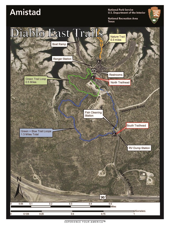
Diablo East Trail Map. Click for printable version.
Diablo East day-use area has three trails: the Blue Trail Loop, the Green Trail Loop, and the Nature Trail. The Blue Trail Loop is about a mile long with its trailhead at the RV dump station. It loops north and west, briefly connects with the Green Trail Loop, runs through the south end of the lower parking area, and returns to the RV Dump Station. The Green Trail Loop is 0.5 miles with its trailhead near the public restrooms on the north end of the lower parking area. The loop runs west and south from here, briefly connects with the Blue Trail Loop and returns through the lower parking area. Hiking the two trails as a connecting circut will provide a longer, 1.3-mile loop.
The short, interpretive Nature Trail (marked on the map with an orange line) begins on the north end of the upper parking area and does a small loop on a point of land near the lake shore. It is .3 miles in length. This trail provides information about a variety of plants, and a hiker can enjoy sweeping views of Amistad Reservoir.
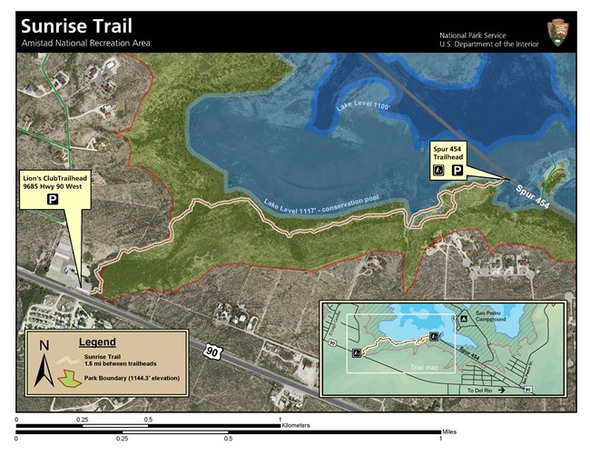
The Sunrise Trail is approximately 1.5 miles long and connects the parking lot at 9685 Hwy 90 West to Spur 454. The hike begins on the Highway 90-side of the covered area but soon after cuts back toward the water. Located on the old Brite Ranch, there often is opportunity to view a large variety of plants and birds on this hike. There are benches on which to sit and enjoy the sweeping views of the lake. The map also depicts where the shoreline is in relation to the trail when the reservoir is at 1117 feet above mean sea level (amsl) in lighter blue and 1100 feet amsl in darker blue. The park boundary is in red. The inset shows where the trail is in relation to San Pedro Campground.
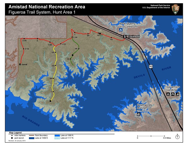
Across the Devils River from Southwinds Marina and Governors Landing is the Figueroa Trail System. The trailhead for this system is near the Rock Quarry Group Campsite. The Figueroa Trail is actually a series of trails that comprise the longest section in the recreation area. Located on the old Figueroa Ranch, these rolling trails cross through desert and shrubland plant habitats, while providing views of the lake and the dam.
CAUTION: The Figueroa Trail System is located within Hunt Area 1. Please be especially vigilant for hazards during hunting season (September 1 - February 28).
South (Blue Trail) Trailhead Parking for Diablo East Trail System. This parking is also shared with the fish cleaning station and RV dump station (must be currently camping in park to use), so please be mindful of the space needed for these activities.
Large, paved parking lot with one designated disabled accessible parking space suitable for a van, 8 standard vehicle spaces, and 32 pull-through spaces suitable for oversized vehicles or those towing a trailer. Multiple picnic tables shaded by large tin-roofed ramadas with grills are adjacent to the lot as is a fish cleaning station and Pecos Nature Trail. Not far from the comfort station/restrooms. Potable water available.
Very limited dirt parking area at end of campground for walk-in (tent) sites and trail. There are restrooms and fee kiosk where camping permits can be purchased with credit or debit card near this area in the main campground. Not suitable for oversized vehicles / vehicles + trailers.
Limited, paved parking for Sunrise Trail. Property owners are allowing the three spaces nearest Highway 90 to be used for this purpose. Suitable for standard vehicles. The Sunrise Trail is approximately 1.5 miles long and connects the parking lot at 9685 Hwy 90 West to Spur 454. The hike begins on the Highway 90-side of the covered area but soon after cuts back toward the water. Located on the old Brite Ranch, there often is opportunity to view a variety of plants and birds.