The border roads remain closed (the dirt roads directly along the border and all crossover roads leading from South Puerto Blanco Drive to the border) to all public vehicle and pedestrian traffic for public safety. South Puerto Blanco Drive remains open.
Gachado Line Camp open. Southeast border road and access roads closed
El Camino De Dos Republicas remains open from SR85 to Gachado Line Camp. Dos Lomitas is not accessible. The southeast border road from Lukeville Port of Entry eastward to the Santa Rosa Mountains is closed to public vehicle and pedestrian traffic.
Natural stone basins, or tinajas, that catch seasonal rainfall are a lifeline for many animals throughout the monument. Tinajas are one of several unique formations and are important to the desert ecosystem.
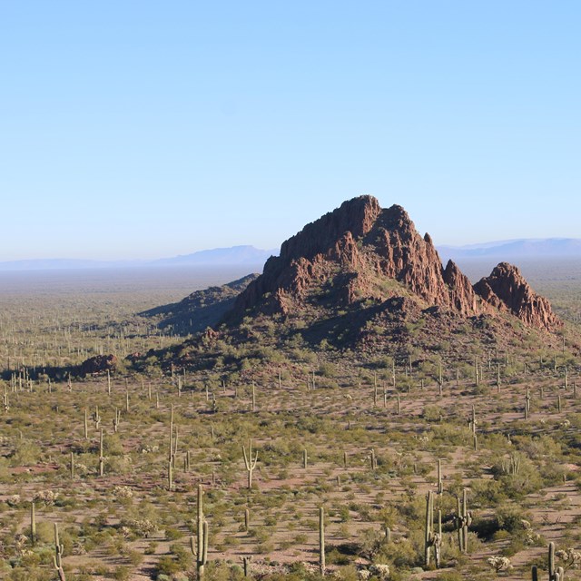
NPS photo
From the highest arch to the deepest arroyo, Organ Pipe Cactus National Monument hosts an incredible array of natural features. Though the modern ecosystems in this area are only about 10,000 years young, the underlying Earth has undergone millions of years of shaping. Ancient volcanoes and winding rivers helped form the landscape, and with a change in climate, a diverse bouquet of life flourished. Today, the Sonoran Desert is believed to have the greatest biodiversity of any desert.
Geodiversity refers to the full variety of natural geologic (rocks, minerals, sediments, fossils, landforms, etc.) and soil resources and processes that occur in the park.
The Sonoran Desert Network Inventory & Monitoring Network consists of 10 park units in central and southern Arizona and one park unit in southwestern New Mexico. Explore their individual geologic history in the Sonoran Desert.
Geology is the scientific discipline dedicated to understanding the physical features and processes of Earth, as well as the history of the planet and its inhabitants since its origin. A basic understanding of the fundamentals of geology can enhance your appreciation of geoheritage sites and scenic vistas. Learn about rocks and minerals, our geologic timeline, plate techtonics, and more!
explore the world's most magnificent rock collection—your National Parks. The science of geology will help you to better understand park scenery and Earth systems. The National Park Service uses science-based conservation methods to ensure that geologic features and systems are protected and remain as a legacy for future generations.
Locations:Big Bend National Park, Death Valley National Park, Dinosaur National Monument, Glacier National Park, Glen Canyon National Recreation Area, Grand Canyon National Park, Great Basin National Park, Lake Mead National Recreation Area, Santa Monica Mountains National Recreation Area, Tule Springs Fossil Beds National Monumentmore »
All across the park system, scientists, rangers, and interpreters are engaged in the important work of studying, protecting, and sharing our rich fossil heritage. Park Paleontology news provides a close up look at the important work of caring for these irreplaceable resources.
Contribute to Park Paleontology News by contacting the newsletter editor
Locations:Big Bend National Park, Dinosaur National Monument, Grand Canyon National Park
Offices:Geologic Resources Division
During the 1930s, public works programs helped uncover paleontological resources at numerous parks. Projects at Big Bend National Park, Dinosaur National Monument, the former Fossil Cycad National Monument, and Grand Canyon National Park are highlighted here from the many stories.
Currently, there is no standardization for paleontological resource information between park units. To address this, the Intermountain Regional Office, the NPS Paleontology Program, and Glen Canyon National Recreation Area have been working to develop a database to manage geospatial information.
Locations:Death Valley National Park, Great Basin National Park, Lake Mead National Recreation Area, Santa Monica Mountains National Recreation Area, Tule Springs Fossil Beds National Monument
Offices:Geologic Resources Division
This year, for the first time, the NPS hired a shared paleontologist to support multiple parks in the same region. Dr. Aubrey Bonde was selected as the Southern Network Paleontologist to support five parks throughout Southern Nevada and California.
Locations:Aniakchak National Monument & Preserve, Arches National Park, Big Bend National Park, Bighorn Canyon National Recreation Area, Bryce Canyon National Park, Canyonlands National Park, Capitol Reef National Park, Chaco Culture National Historical Park, Colorado National Monument, Curecanti National Recreation Area, Denali National Park & Preserve, Dinosaur National Monument, Gettysburg National Military Park, Glen Canyon National Recreation Area, Katmai National Park & Preserve, Lewis and Clark National Historical Park, Mesa Verde National Park, Navajo National Monument, Petrified Forest National Park, Pipe Spring National Monument, Rainbow Bridge National Monument, Springfield Armory National Historic Site, Valley Forge National Historical Park, Wrangell - St Elias National Park & Preserve, Yellowstone National Park, Yukon - Charley Rivers National Preserve, Zion National Parkmore »
Offices:Geologic Resources Division
Dinosaur fossils have been discovered at or are associated with at least 27 NPS units. Geographically, their finds are concentrated in the parks of the Colorado Plateau, but they have been found from central Alaska to Big Bend National Park in Texas to Springfield Armory National Historic Site in Massachusetts. The most famous site is the Dinosaur Quarry of Dinosaur National Monument, but a rush of new finds since the 1970s has greatly expanded our knowledge.
Each park-specific page in the NPS Geodiversity Atlas provides basic information on the significant geologic features and processes occurring in the park.
Each park-specific page in the NPS Geodiversity Atlas provides basic information on the significant geologic features and processes occurring in the park. Links to products from Baseline Geologic and Soil Resources Inventories provide access to maps and reports.
Each park-specific page in the NPS Geodiversity Atlas provides basic information on the significant geologic features and processes occurring in the park.