Spanish Exploration of the Great Plains

Color copy of Remington's Coronado Expedition painting.
Frederic Remington's painting of the Coronado Expedition as it leaves New Mexico in 1541 to explore the North American Great Plains.

Public Domain

Searching for Wealth Beyond the Sunset

Motivated by “God, Gold and Glory” Spain sent a series of military expeditions to explore the Great Plains beginning in 1541. Converting Indians would bring glory to the converter in an age that related everything to religion, but the real draw was finding wealth in the fantastic, mythical kingdoms that always seemed to lie to the west, just beyond the currently explored territory.

To medieval Europeans, the land to the west of them was a magical and mysterious place full of wonderous creatures like monsters and giants, and fantastic places full of riches like King Soloman’s mines, the Seven Cities of Cibola and Quivira. It’s no surprise, then, that stories of another great Indian civilization even richer than the Mayans and Aztecs inspired Coronado to explore the plains.

By the 1600s it became apparent that these places didn't exist and more practical considerations guided their explorations: converting the natives, colonization and finding a northern water route across the continent, which would give them some advantage over British pirates raiding their settlements along the western coast of South America.

Throughout the 1700s, military reconnaissance and trade relations with their neighbors were the focus of their journeys into the plains. By 1821, Mexico’s independence ended Spain’s influence on the North American continent, opening the way for the newly formed United States and its eventual settlement of that vast region.

Opening a Future Trade Route

Because they followed the Arkansas River, many of these expeditions came through this area of Kansas. These journeys pioneered the route that William Becknell would later use in 1821 to open up the Santa Fe Trade. They started out from the area now known as New Mexico and by 1821, the year Becknell opened the Santa Fe Trail, there was hardly a place on the Great Plains that had not been explored by the Spanish.

Now we will speak of the plains. The country is spacious and level, and is more than 400 leagues wide in the part between the two mountain ranges....No settlements were seen anywhere on these plains....The country is like a bowl, so that when a man sits down, the horizen surrounds him all around at the distance of a musket shot.
- Pedro de Castañeda, Chronicler of the Coronado Expedition

1541 to 1634 - Early Explorations

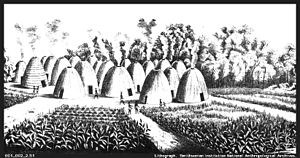
Black & white drawing of 19th century Wichita Indian village.
Sketch of a Wichita (Kansas) Indian village in the 19th century. Both the houses and surrounding cornfields appear similar to what Coronado described in 1541.

Public Domain

1541 - Vasquez de Coronado

Coronado set out from the area of New Mexico with 350 soldiers. Inspired by the stories of an Indian named the Turk, he was searching for the Seven Cities of Cibola, a legendary place of amazing wealth. After marching about 650 miles without finding anything, Coronado realized the Turk had misled them. He sent back all but 30 of his men and used Texas Indians as guides from that point on. They would eventually reach a village of grass covered huts near Lyons, Kansas, which Coronado named Quivira. Most of the route Coronado used on his return to New Mexico would later become the Santa Fe Trail.

Although he planned to continue the search for gold, he was seriously injured after falling from his horse and had to return to New Spain. The Spanish government halted any further exploration into new territory so they could consolidate their hold on presently held lands and concentrate on mining silver in Mexico.

Eventually others grew interested in returning to the area of New Mexico. Although Coronado had not found any gold, many people believed it was still there to discover. There was also an interest in converting the Indians, as well as establishing a more permanent presence in order to use it as a base for further explorations.

1595 - Francisco Leyva de Bonilla & Antonio Guitiérrez

Leyva and Guitiérrez led an unauthorized expedition looking to make a name for themselves and possibly become governors of new Spanish provinces in New Mexico. Their journey took them near present-day Wichita, Kansas before tragedy struck the group. The two leaders fought with each, and eventually Guitiérrez murdered Leyva. Shortly after that the remaining soldiers were attacked by Plains Indians who killed everyone but one Indian servant.

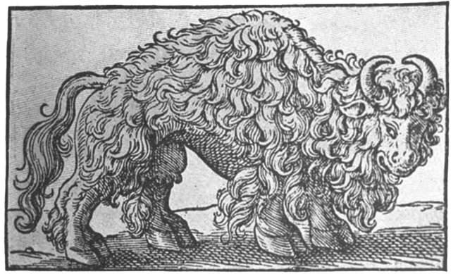
Black & white photo of earliest known bison drawing.
Earliest known drawing of a bison from 1554.

1601 - Juan de Oñate

By 1595, Leyva and Guitiérrez’s expedition, along with others, finally prompted the viceroy in Mexico City to authorize Juan de Oñate to start a settlement in New Mexico. Oñate would eventually set out in 1598, leading 129 soldiers and their families, 83 wagons and 700 head of livestock.

He established a settlement at a place he named San Juan de los Caballeros, then spent the time between 1600 and 1604 sending other expeditions out to explore the region. He led one trip himself in 1601 that went as far as present-day Wichita, Kansas.

Although Oñate did not cover any new territory, his was the largest expedition to venture into the plains up to that time. It was also the first time wagons crossed the great plains.

1634 Alonso Baca

Baca, along with “some men” left Santa Fe and traveled as far as Quivira, mostly using the route of the future Santa Fe Trail. Hostile Indians forced him to return but not before reaching a large river that some people believe was the Mississippi.

1720 to 1806 - Trade and Diplomatic Missions

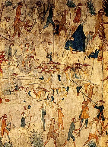
Ledger art drawing of the attack on the Villasur Expedition.
The Pawnee Indians and their French allies surrounded and defeated the Villasur expedition.

1720 - Pedro de Villasur

During the 1700s the Spainish were increasingly threatened by foreign competitors in North America. Stories reached them about other white men on the plains and it soon became apparent that the French were moving in on their territory. By 1700 the French were settling into the area of Illinois and the Mississippi River Valley, as well as along the Missouri River.

New Mexico governer Antonio Valverde y Cosio sent Villasur to “make a reconnaissance of the settlements which they say those of the French nation have established.” He took 43 soldiers, 3 settlers and 60 Pueblo Indians to look for the French. Although they found no Frenchmen, they were ambushed by Indians using French weapons. Only 13 Spaniards survived the attack and made it back to Santa Fe.

1792 - Pedro Vial

For the next 60 years the Spanish put their explorations on hold while they fought the Comanche. After establishing peace with them, they looked beyond New Mexico, this time in search of trading opportunities with their neighbors. France had handed Louisiana over to Spain in 1763 and Governor Fernando de la Concha decided it was time to open trade relations with the new Mexican province.

He asked Vial, a Frenchman from New Orleans who became a Spanish citizen, to lead a trip to St. Louis to open trade and communications with the French in Louisiana. Vial had only two other companions who made the trip with him. They were captured by Indians on the way who took them in the direction they were going anyway. Their return trip was uneventful.

1806 - Facundo Melgares

In 1800, Spain gave Louisiana back to the French, but immediately France turned around and sold the territory to the U.S. in 1803. By 1805, Americans began arriving in Santa Fe and in the following year Zebulon Pike led an expedition to the San Luis Valley in New Mexico mostly following the route of the Santa Fe Trail. He arrived in the valley in January of 1807, where New Mexican soldiers briefly detained him for trespassing.

In 1806, Melgares went with 105 soldiers, 400 militiamen and 100 Indians to search the plains for these foreign intruders into New Mexico. At one point he left 240 of his troops camped along the Arkansas River a few miles southwest of present-day Larned, Kansas. Although he traveled widely through the plains, going as far as the Republican River in Nebraska, he did not encounter any foreigners, apparently missing Pike’s expedition by a month.

Last updated: August 15, 2024

Park footer

Contact Info

Mailing Address:

1767 KS Hwy 156
Larned, KS 67550

Phone:

620-285-6911
This phone is answered during regular business hours. After hours calls will be answered the next day. Please select a mailbox or leave a message on the main extension when the fort is closed.

Contact Us