|
The Parkway conserves diverse and important examples of architecture, industry, and transportation associated with the people and communities of the mountains in southern Appalachia. The Parkway contains, and is challenged to manage, a diverse range of cultural resources, including 91 buildings, 2 sites, and 133 other structures that contribute to the Parkway's eligibility for inclusion on the National Register of Historic Places. Explore hundreds of historic photographs of the parkway and Blue Ridge region on NPGallery or Driving Through Time. 
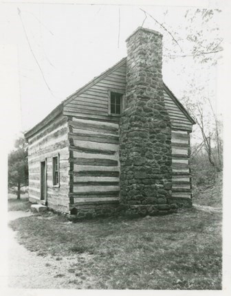
NPS photo BuildingsThe parkway preserves a variety of historic buildings, either as interpretive exhibits or as picturesque roadside features. With the exception of the imposing neoclassical estate of textile magnate Moses Cone, the structures tend to be modest structures, mostly simple log cabins. The early parkway planners thought the log cabin symbolized pioneer Appalachia, and preserved or relocated a good number of log structures to points along the road. Ironically, they removed a number of earlier frame houses because they did not meet their stereotypical vision of the Appalachian past. Parkway planners adopted their own variant of the prevailing "rustic style" of architecture adopted in the national parks. They wanted their own structures to reflect the architecture of the region, and consequently took on the forms of cabins, sheds, and barns in order to enchance a "backwoods feeling." Structures employed timber beam construction, shake roofs, stone chimneys and exterior porches. Even the "driftwood gray" color was specified to present a weathered appearance. With few expections, even modern structures along the parkway, such as the 1989 Linn Cove Visitor Center or the 1999 Everhardt Headquarters Building at Asheville continue to reflect "pioneer" architecture through their use of native materials, allowing them to harmonize with the rugged landscape. Text excerpted from "Highways in Harmony" publication produced by Historic American Engineering Record (HAER), in cooperation with the National Park Foundation. Historic Parkway Photos and MapsBlue Ridge Parkway Digital Archives are accessible online through the NPGallery Digital Asset Management System. The digital archives include the Blue Ridge Parkway Historic Photograph Collection, which contains digital copies of photos documenting construction of the parkway, ranger-led programs, special events, staff portraits, general tourism, scenic views, and recreational activities from the 1930s to 1970s. Parkway Land Use Maps (PLUMs) and drawings are also available. All digital assets can be downloaded free of charge. Each digitized item is also assigned geographic coordinates so that it can be viewed on a map, enabling users to visualize and analyze the impact of the Blue Ridge Parkway on the people and landscape of western North Carolina and southwest Virginia. Many historic maps (including North Carolina Parkway Land Acquisition Maps and the Park Service's Parkway Land Use Maps for North Carolina) are "georeferenced" (aligned with present landscapes so past and present can be compared). Interpretive essays, called "overlooks," introduce viewers to new research on parkway history, and K-12 lesson plans invite teachers to use the site's primary source collections in teaching.

Blue Ridge Parkway Digital Archives
The digital archives contain photos of the park, ranger programs, scenic views, recreational activities and more from the 1930s to 1970s. 
Cemeteries along the Blue Ridge Parkway
Discover the cemeteries along the parkway that tell the varied stories of those who settled and lived in the Appalachian Mountains. |
Last updated: February 13, 2025
