In 1991, Congress authorized the purchase of a 4,011 acrea expansion along the southern boundary of the Rincon Mountain District of Saguaro National Park. These lands preserve scenic areas of the Sonoran Desert as well as a portion of the riparian area along Rincon Creek. Some of the lands within the expansion area remain privately owned and are closed to public use.TrailsThe Loma Alta trailhead is located at the north end of Camino Loma Alta. The last 1/2 mile of this road is unpaved, rocky and subject to washouts—turn around if Rincon Creek is flooding the road. Horse trailers must be parked in the lower area just beyond where the pavement ends. Passenger cars may continue to the trailhead at the end of the road, but space is limited and often fills on weekends. A trail system using old ranch roads—revegetated and restored—provides access to many scenic areas. Signs around this area give insight to the story of settlement and ranching in the valley. 
NPS Photo / TWiewel Hope Camp Trail7 miles (11.3 km) out-and-backThis trail heads east from the Camino Loma Alta trailhead, offering spectacular views of Tanque Verde Ridge and Rincon Peak. Pass Deer Camp and Hope Camp—both of these camps are historic cowboy gathering areas—then travel about 1/2 mile to the boundary. If you do not turn around but continue to hike outside of the park boundary, you will find yourself on the Arizona National Scenic Trail headed to the Arizona-Mexico border.Ridgeview Trail2.2 miles (3.5 km) out-and-backThis short but moderately steep trail climbs to a turn-around with scenic views of the rocky side canyons of Tanque Verde Ridge and a towering Rincon Peak in the distance.Ruiz and North Coyote Wash Trail5.8 miles (9.3 km) loopThis lesser-used trail creates a loop just south of the Hope Camp trail. Starting at the Camino Loma Alta trailhead, continue east on Hope Camp trail for 0.8 miles to North Coyote Wash trail on teh right. Proceed down the wash, keeping your eyes open for large and unusual saguaros. At the junction of the Ruiz trail, head left and onto a low ridge with expansive views. At Hope Camp trail, turn left for the 1.3 mi (2.1 km) hike back to the starting point.Arizona / Quilter TrailThe Arizona National Scenic Trail spans the state north to south from Utah to Mexico, and roughly 17 miles of Section 9 of the trail pass through Saguaro National Park. Hiking from the Loma Alta trailhead, you will encounter the Arizona / Quilter trail 2.5 miles in on your left. The Quilter trail alone is 4.8 miles (7.7 km) ending at a mid-elevation trail junction in the Saguaro Wilderness Area. Bicycles may enter Saguaro National Park by way of the east end of Hope Camp trail. However, because the law prohibits bicycles in wilderness areas, all cyclists must continue west on Hope Camp trail to exit at Camino Loma Alta. The Natural SceneThe Rincon Mountains command the view from the Hope Camp Trail. Geologically distinctive as a metamorphic core complex, these highlands rise above the Catalina Fault at trail level. From west to east, Tanque Verde Peak (7,049'), Mica Mountain (8,666') and Rincon Peak (8,482') cut the skyline. As the only designated wilderness "sky island" in southern Arizona, the Rincons offer an entire mountain range for free-roaming wildlife and freedom-loving visitors.The southern exposure and well-drained gravel soils along Rincon Valley trails are perfect habitat for saguaros. Here, too, is the northernmost stand of the tropical Feather Tree. In years of good fall & winter rains this area may come alive with wildflowers including Mexican gold poppies, a popular favorite otherwise rare in the Rincon Mountain District. Watch for Gila monsters, desert tortoises and several species of snakes along the trails. 
NPS Photo / TWiewel History of the AreaHundreds of years of human use have left their mark on the Rincon Valley. In the 13th and 14th centuries, people of the Hohokam culture lived in small villages along the floodplain of Rincon Creek. They harvested saguaro fruit, mesquite beans and other wild foods. They hunted for deer and bighorn sheep in the Rincon Mountains and planted corn, beans and squash in the fertile valley. The people left many petroglyphs as a mark of their passing.Hispanic and Anglo settlers wrestled a living from the high desert plains and saguaro forests, too. The first of these European settlements were small family farms, but soon large cattle ranches dominated the area. Well into the 20th century, the dominant ranches were the Rocking K and X-9, named for their distinctive livestock brands. The old ranch roads you walk as trails today once echoed to the shouts of cowboys and the bellowing of cattle. Line camps used for round-ups are now marked by rustling windmills and equipment. Deer Camp to the west and Hope Camp at the east end of the trail are two such camps. Both ranches are part of burgeoning suburban development around Tucson. But portions are now in public ownership in your Saguaro National Park. 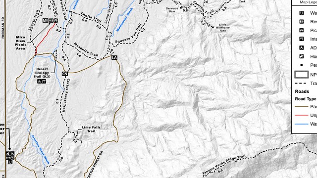
Maps
Our maps help you plan your trip and keep you safe navigating our wilderness. 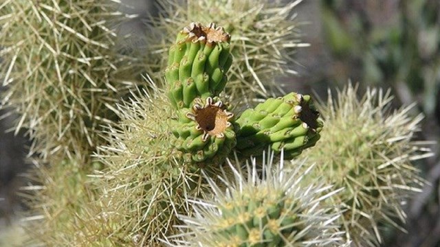
General Hiking Safety Information
Safety information to help ensure you stay safe while having fun in the park, and what to do in sticky situations. |
Last updated: November 30, 2024