An official website of the United States government
Here's how you know
Official websites use .gov A
.gov website belongs to an official government
organization in the United States.
Secure .gov websites use HTTPS A
lock (
) or https:// means you've safely connected to
the .gov website. Share sensitive information only on official,
secure websites.
Read Along Videos: Lewis and Clark Trail Junior Ranger
About these videos
Welcome!The videos below narrate and audio describe the Lewis and Clark Trail Junior Ranger Activity Journal. Grab your booklet and play the videos to read along.
These audio described read along videos read the text and describe the imagery of the Lewis and Clark Trail Junior Ranger Activity Journal, a 16 page booklet that kids can complete to earn a Junior Ranger badge. There are nine videos, one for the cover, one for each of the seven booklet spreads, and one for the Junior Ranger pledge and certificate. Videos feature the voices of different storytellers as well as pronunciation of Indigeous names of plants and animals. Plain text audio descriptions are also available in a drop down panel above each video.
BOOKLET COVER
OVERVIEW
Activity booklet cover in the style of composition notebook. A larger Lewis and Clark Trail logo is in the center of a blue background, background is filled with playful drawings. There is a space to write in your name in the center of the booklet, about three inches, from the top.
TEXT
Activity Book cover reads "Junior Ranger Activity Journal."
Directions. Work on this book. Pick the activities you like best. Turn in your book at a participating location along the Lewis and Clark Trail.
Take the Junior Ranger Pledge to receive a Junior Ranger Badge.
Space to write in your name at the top center of the booklet.
IMAGES
Lewis and Clark National Historic Trail logo. In a rounded white triangle emblem, two explorers look into the distance. Background of booklet. Illustrations of a boat, fish, sextant, compass, earth lodge, bison, dog, cactus, badge, and pronghorn on blue background.
This video narrates and audio describes the cover of the Lewis and Clark Trail Junior Ranger activity booklet. Follow along in your booklet, or turn on closed captions.
ON TRIBAL LANDS
OVERVIEW:
This two page activity spread is titled, "On tribal Lands." It features an illustrated map of tribal territories that spans both pages. On the left, first page, the activity begins with an introduction and activity. On the right page, there is a main acitvity, and two small optional activities. A footer features a date and event in the Lewis and Clark Expedition timeline.
LEFT PAGE:
On Tribal Lands. Today the Lewis and Clark National Hisotric Trail passes through 16 states, from Pennsylvania to the Pacific Coast. But long before the Lewis and Clark Expedition and the drawing of state lines, a huge web of tribal territories was already here. Having endured centuries of broken treaties, stolen land, and relocation, these tribal nations remain today.
Directions. On whose homeland are you standing right now? Ask at the site you’re visiting, or visit www.native-land.ca/
Space in top middle of the page to write in answer.
RIGHT PAGE:
Directions. Read the descriptions of tribes in the early 1800s then on the map below, fill in these tribes: Mandan, Clatsop, and Shoshoni.
Pacific Coast tribes like the Clatsop and Chinook, traded sea otter fur for copper and other European goods. Dried salmon was traded between tribes. Ocean-going canoes and totem poles were carved from spruce and cedar forests. Woven hats shed the rain.
The Nez Perce, Shoshoni, and other tribes of the Rocky Mountains, relied on salmon to their west and bison to their east. The Blackfeet used portable teepees during bison hunts. Beaded cradleboards, horse blankets, and woven baskets were useful and beautiful.
For the Mandan, Arikara, and other Great Plains tribes along the Missouri River, corn, beans and squash were valued crops. Earth lodge villages were busy trade centers. Buffalo boats were used for travel. Works of history and art were painted on buffalo robes.
ILLUSTRATED MAP DESCRIPTION:
On the left or west is the Pacific Ocean. Along the coast here are dense spruce forests, canoes, totem poles, salmon, and woven hats. Tribes listed include Cowlitz, Yakama, Umatilla (you-mah-till-uh), Chinook, Nehalem (neh-hale-lem), and Tilamook......... Moving to the right or east along the Columbia River, we reach the Rocky Mountains. Illustrated here are bison, teepees, a cradleboard, and horses with horseblankets. Tribes listed include: Blackfeet, Salish, Kootenai (koot-en-knee), Nez Perce, Crow. Moving right or east along the Yellowstone and Missouri Rivers, we reach the Great Plains of the midwest: Bison, grasses, earth lodges, buffalo boats, and corn are drawn here. Listed Tribes include: Hidatsa, Arikara, Teton Sioux, Ponca, Omaha, Osage (Oh-sage), and Shawnee.
Three blank spots on the map. One on the Pacific Ocean coast. One in the Rocky Mountains. One in the Great Plains.
Small inset of the continental U.S. shows a box over the northwest and midwest portion of the country, showing that the illustrated map relates to this area.
BONUS ACTIVITY:
Your Home. If you are part of one of these tribal nations, circle it on the map.
BONUS ACTIVITY:
East of the Missouri. Find the National Historic Trail map with tribal territories in the east, at www.nps.gov/lecl.
EXPEDITION TIMELINE:
Boat icon. August 30, 1803. Pittsburgh. “Left Pittsburgh this day at 11 ock with a party of 11 hands... they having proposed to go with me throughout the voyage. Arrived at Bruno’s Island 3 miles below” —Meriwether Lewis.
This Junior Ranger read along video narrates and audio describes the Lewis and Clark Trail Junior Ranger activity, On Tribal Lands. Follow along in your booklet, or turn on closed captions.
LET'S EMBARK
OVERVIEW:
This two page activity spread is titled, "Let's Embark." It features a map of the Lewis and Clark National Historic Trail and a bullets list of fast facts. On the first, left page, is one activity. On the right page are two activities and a caption. A footer features a date and event in the Lewis and Clark Expedition timeline.
LEFT PAGE:
Map description. Map of United States. A red line marks the Lewis and Clark Expedition. The route winds along the Ohio River southwest from Pittsburgh to St. Louis. Northwest along the Missouri River to Omaha and Great Falls. The route continues west along the Columbia River to Astoria and the Pacific Ocean. The Yellowstone River cuts through the mountains.
Note: There may be a tactile map of the Lewis and Clark Trail at the site you are visiting. Ask a site employee for details.
Directions. What site are you visiting today? Write below. Bonus Mark an X on the map above.
Lewis and Clark National Historic Trail.
LENGTH: 4,900 miles
ROUTE: Pittsburgh, PA to the Pacific Ocean and back
CROSSES: Territories of 65+ tribes
EXPEDITION DURATION: 3 years between 1803 and 1806
CAPTAINS: Meriwether Lewis and William Clark
Most of the route is by river.
ILLUSTRATIONS.
Drawing of a big, black, fluffy dog. Lewis’s dog Seaman. Lewis and Clark Trail sign. Drawing of three boats on a river.
RIGHT PAGE:
Directions: Why is this site important to the Lewis and Clark Trail? Look for clues on signs and exhibits or ask someone who works there. Write, draw, reenact, or make up a song.
Directions. Discuss with your group or reflect: how do you show respect when visiting someone’s home? Remember, As a visitor to an ancestral homeland you are responsible for respectful behavior.
EXPEDITION TIMELINE:
Icon two people shake hands. October 14, 1803. Falls of the Ohio. Captain Meriwether Lewis and crew arrive at Port Louisville on the expedition’s keelboat and one pirogue. It is here that Lewis joins Co-Captain William Clark.
This Junior Ranger read along video narrates and audio describes the Lewis and Clark Trail Junior Ranger activity, Let’s Embark. Follow along in your booklet, or turn on closed captions.
MEMBERS OF THE EXPEDITION
OVERVIEW:
This two page activity spread is titiled, "Members of the Expedition." It features paintings of four expedition members and a code in which a shape matches with a letter. Participants use the code to uncover the names of the four expedition members. Another activity asks participants to put five people in order. One bonus activity. A footer features a date and event in the Lewis and Clark Expedition timeline.
LEFT PAGE:
Members of the Expedition. The Corps. More than thirty people were part of the Lewis and Clark Expedition.
Directions: Use the code to decode the names of these expedition members.
The Code. Straight arrow = A. Left half of circle = C. Right half of circle = D. Square = E. Circle with straight line = G. Stacked squares = I. Zig zag = K. L shape = L. Circle = O. Right arrow = R. Circle with diagonal line = S. Cross = T. U shape = U. W shape = W. Down arrow = Y. Hourglass = Z.
Image description: painting of a young black man looking into the distance. He holds a rifle. A deer is slung over his shoulders. He wears early 1800s clothing.
Credited as the first African American to cross the continent, he helped the Corps overcome the daunting odds of survival. Tribes sometimes cooperated with the expedition just so they could meet him. Oral histories remain describing this strong man with black skin. Though he was enslaved—the body servant to William Clark— and never received payment, he hunted, rowed, and labored along-side the other members of the expedition.
Directions. Decode the name of this expedition member. Four letters. Down arrow. Circle. Right Arrow. Zig Zag.
[Pause to complete.]
RIGHT PAGE:
Image description. Painting of man playing fiddle.
Of French and Omaha ancestry, this expedition member was skilled in Indian sign language. He excelled in navigating rivers. He spotted routes and obstacles even though he had use of only one eye.
Directions. Decode the name of this expedition member. Eight letters. Left half of circle. Right arrow. U shape. Hourglass. Straight Arrow. Cross. Cross. Square.
[Pause to complete.]
Image description. Man with long dark hair and a bandana looks on.
With “uncommon skill as a hunter and woodsman” and an ability to translate Indian sign language as well as French, this Shawnee and French-Canadian recruit was one of the most valued members of the expedition.
Directions. Decode the name of this expedition member. Ten letters. Right half of circle. Right arrow. Circle. U shape. Stacked squares. L shape. L shape. Straight arrow. Right arrow. Right half circle.
[Pause to complete.]
Image description: Painting of Young woman with dark hair and braids.
This Shoshoni woman and her baby’s presence in the expedition signaled peace. Just a teenager, she was known for her calm perseverance. In Spring 1805 when an expedition boat began to capsize, she saved the scientific instruments and papers on board.
Directions. Decode the name of this expedition member. Nine letters. Circle with diagonal line. Straight arrow. Left half of circle. Straight arrow. Circle with straight line. Straight arrow. W shape. Square. Straight arrow.
[Pause to complete.]
Directions: Fill in the order these people should speak, to translate Shoshoni to English.
Chief Cameahwait — speaks Shoshoni.
Charbonneau — speaks Hidatsa and French
Labiche — speaks French and English
Sacagawea — speaks Shoshoni and Hidatsa
Lewis & Clark: speak English
Hint: Chief Camehawait is first in the translation chain, and Lewis and Clark are last.
[Pause to complete.]
BONUS ACTIVITY:
The Real Deal. This translation chain really happened— in the summer of 1805 when the Corps needed Shoshoni horses to cross the Rocky Mountains.
Bonus: Ask at the site you’re visiting: What stories took place here? Who was involved?
EXPEDITION TIMELINE:
Icon of two hands in a handshake. August 3, 1804. Council Bluffs. Chiefs from Otoe and Missouria tribes meet with the captains. The tribes’ participation makes the expedition’s first attempt at diplomacy a relative success.
This Junior Ranger read along video narrates and audio describes the Lewis and Clark Trail Junior Ranger activity, Members of the Expedition. Follow along in your booklet, or turn on closed captions.
CROSSING THE CONTINENT
OVERVIEW:
This two page activity spread is titled, "Crossing the Continent." It features a large maze that spans both pages. The main directs participants to complete the maze. There is one bonus activity. A foot features a date and event in the Lewis and Clark Expedition.
IMAGE DESCRIPTION.
A maze spans both pages. The maze looks like a twisted map, with drawings of trees, mountains, and earthlodges. On the eastern or left side of the maze, a keel boat points west and says "Start, Summer 1804, with boats, crew, and supplies procured in Pittsburgh and along the Ohio River." At the end of the maze at the western or right side, a fort says "End. Fort Clatsop Winter camp December 1805 - March 1806." Between the start and end, the are five parts of the maze that present a choice. One choice allows you to proceed on, while the other is a dead end. The beginning of the maze, on the eastern or right side, is golden to represent the Great Plains. Scattered between the maze here are earth lodges, and bison. The middle of the maze is warm green. It winds through mountains. The maze ends on the left page (the west) in a tangle of pine trees that ends on a coast.
ACTIVITY.
Directions: As you travel through the maze, read each scenario and make a choice.
Hint: The expedition relied on food, aid, supplies, information, and peace offered by tribes.
Start the maze. Along the Missouri River, the expedition and the Teton Sioux are on the verge of violent conflict. Sioux Chief Black Buffalo deescalates the situation and negotiates peace. Choose: Fight with the Sioux or Accept Peace. [Pause to decide...]
Fight with Sioux dead ends in conflict. Accept Peace to move ahead.
Maze moves through Great Plains, bison, earth lodges. A bitterly cold, windy winter sets in on the Great Plains. Nearby Mandan have stores of food, knowledge of the area, and are willing to trade. Choose: Partner with the Mandan, or winter alone. [Pause to decide....]
Winter alone dead ends. Partner with Mandan to move ahead.
Maze moves west. It’s spring. The Hidatsa offer information about the journey ahead and where to find the Shoshoni. Choose: Explore for Yourselves? Or Follow Hidatsa advice? [Pause to decide...]
Explore for yourself dead ends in stuck. Follow Hidatsa advice to move ahead.
Maze approaches mountains. The Shoshoni agree to sell horses for the mountain crossing. Choose: Buy horses? Or Cross without help? [Pause to decide...]
Cross without help dead ends with "stuck" and "lost" in the mountains. Buy horses to move ahead.
Maze moves deeper into the mountains. Choose: Forge a trail through the mountains? Or Use a Shoshoni Trail and go with a Shoshoni Guide. [Pause to decide...]
Forging your own trail dead ends, LOST in the mountains. Go with a Shoshoni guide to move ahead.
Maze exits the mountains towards the coast. Starving, the expedition emerges from the mountains. Choose: Go on without help? Or Receive food and aid from the Nez Perce? [Pause to decide...]
Ask Nez Perce for food and aid to proceed.
The expedition paddles down the Columbia River, through the territory of powerful tribes. Tribes allow expedition to proceed. Maze winds through forests. Whales spout off the coast.
End!
End of main activity.
BONUS ACTIVITY:
Ask at the site you’re visiting: How did the Lewis and Clark Expedition and the local tribes interact here? Was there peace? Conflict? Celebration? Tension?
EXPEDITION TIMELINE:
Icon of canoe being dragged. June 17, 1805. great falls portage. The expedition begins the monumental task of carrying boats and supplies across 18 miles of rough wet terrain, around the Great Falls of the Missouri.
This Junior Ranger read along video narrates and audio describes the Lewis and Clark Trail Junior Ranger activity, Crossing the Continent. Follow along in your booklet, or turn on closed captions.
NATURE JOURNALING
OVERVIEW
This two page activity spread is titled, "Nature Journaling." On the left page, illustrations of plants and animals are paired with their name in an Indigenous language, the name of that language, and their common name in English. You can hear these native names by visiting nps.gov/LECL/native-names.htm. Rough phonetic approximations are written below. An activity asks participants to match a journal entry by Captain Lewis to a plant or animal on the list. The right page features a notepad with various prompts for nature journaling observations. A footer features a date and event in the Lewis and Clark Expedition.
LEFT PAGE
Title: Nature Journaling.
Image description. Illustrations of plants and animals.
Plant with potato like root. Qáamsit. (Cam-sit) Nimipuutímt. Nim-MI-poo-TIMPT/ Nez Perce. cous root
Three silver fish. kwənat. (Gwan-net) Chinuk Wawa. Salmon
Plump bird with large tail feathers. Huittsaan. (Witch-cha) Shoshoni. sage grouse.
Prairie dog jumping as it calls. Pispíza. (Peez-Pe-za) Lakota Sioux. prairie dog
Lime green bumpy round fruits with leaves. Oonsaawaahkwa. (Ooo-sa-wha-kwa) Myaamiaataweenki.(Me-ya-me-ah-tah-when-kay) Osage orange.
Directions: Read the journal entry below. On the right, circle the plant or animal being described.
March 13 1806. Fort Clatsop. “Inhabitants of both the sea and rivers ... It is this species that extends itself into all the rivers and little creeks on this side of the Continent, and to which the natives are so much indebted for their subsistence... The body of this fish is from 2-1/2 to 3 feet long and proportionably broad.” —Captain Meriwether Lewis.
[Pause to complete.]
Directions: Name two animals native to the site you are visiting today.
[Pause to complete.]
RIGHT PAGE
Directions: Go outside and find something in nature that interests you. Spend 5 quiet minutes using your senses to examine it. (Careful! Talk with a site staff about what is safe to touch and examine.) Record your observations below.
Size? Mark how big it is on the line below. Line goes from tiny, to a the size of a hand, size of a person, size of a car, then huge.
Draw or write your observations.
[Pause to Complete.]
Find a plant that is native to the site you are visiting. Bonus: What special knowledge do local tribes have for this plant? Draw, write, or discuss.
[Pause to complete.]
End of main activity.
DID YOU KNOW?
The journals. How many animals did the Expedition discover? Zero! Captain Lewis described 122 animals that were new to western science but already known to local tribes. Lewis’s detailed notes often included tribes’ knowledge of the species.
EXPEDITION TIMELINE.
Ocean icon. November 15, 1805. Pacific Ocean. A break in turbulent weather allows the expedition to exit the Columbia River and finally and officially reach the Pacific Ocean.
This video narrates and audio describes the Lewis and Clark Trail Junior Ranger activity, Nature Journaling.
Special thanks to MHA Language Project, Nez Perce Language Program, The Confederated Tribes of Grand Ronde, Chinuk Wawa Education Program, Shoshoni Language Project, Lakota Language Consortium, New Lakota Dictionary (NLD) Mobile App, Myaamia Center @ Miami University. NOTE: phonetic captions for the native speaker pronunciations are rough approximations only.
EXPERIENCE THE TRAIL
OVERVIEW
This two page activity spread is titled, "Experience the Trail." On the left apge a flowchart invites kids to pick and adventure along the trail. Participants follow a series of questions which leads them to five options: kayak, bike, drive, walk, or canoe. On the right page, five adventures are listed for kayaking, biking, driving, walking, and canoeing along the Lewis and Clark Trail. An illustration depicts these adventures. an activity invites participants to write to a friend, and gives blank space. A footer features and date and event in the Lewis and Clark Expedition.
LEFT PAGE
Experience the Trail.
Image description. A flowchart leads to five options: kayak, bike, drive, walk, canoe.
Directions: Use the flowchart to pick an adventure.
How much experience / skill do you have in the outdoors? A lot? Some? Not much?
[Pause to decide.]
All answers lead to: The trail is for everyone. With proper planning, anyone can go play! Cool!
Next.... How are you feeling today? Secretive like a seal? High energy like a coyote? Curious like a magpie?
Images: drawings of a seal popping out of the water, a coyote face, and a black and white magpie bird looking over its shoulder.
[Pause to choose.]
Seal leads to kayaking. Coyote leads to River - kayaking, or mountains - biking. Curious like a magpie leads to drive in a car.. walk in your boots ... or canoe!
RIGHT PAGE
Adventures listed.
Kayak the lower Columbia River Water Trail.Paddle within the ancestral homeland of Columbia River tribes.
Bike Lemhi Pass to Lolo Pass. Pedal over the same mountains and passes the Shoshoni guided the expedition through.
Drive Knife River to Great Falls. Visit the earth lodges of Knife River Indian Villages and Fort Union Trading Post.
Walk. Wickliffe Mounds State Historic Site. Learn about Mississippian culture, go bird watching, enjoy a picnic.
Canoe Ohio River Recreation Trail. Paddle through history and nature. This is the first river the expedition traveled on!
Image description. Kayakers paddle on the ocean, person on a bicycle rides through the mountains past teepees. Car drives through the Great Plains past earth lodges. Person walks through green mounds. Canoers paddle at sunrise.
Directions: Lewis invited Clark to be his Co-Captain on the now iconic expedition. Above, write a note inviting a friend or family member to join you on an experience along the Lewis and Clark National Historic Trail.
[Space to write and draw in middle of page.]
End of main activity.
EXPEDITION TIMELINE
Icon of small boat. July 3, 1806. Yellowstone river. On the return route east, the expedition divides into two groups. Lewis leads one group to survey the Marias River. Clark leads a group along the Yellowstone River.
This Junior Ranger Read Along video narrates and audio describes the Lewis and Clark Trail Junior Ranger activity, Experience the Trail. Follow along in your booklet, or turn on closed captions.
STORYTELLERS ON THE TRAIL TODAY
OVERVIEW
This two page activity spread is titled, "Storytellers on the Trail Today." On the left page, three portraits are featured along with three word bubbles. Participants match ther quotes to the storyteller. On the right page, participants have room to draw themselves as a storyteller and fill in a word bubble to tell their experience. A bulleted list entitled "proceed on" invites participants to go to www.nps.gov/lecl and find new things to do. A footer features two dates of importance to the Lewis and Clark Expedition.
LEFT PAGE
Storytellers on the Trail Today
Directions: Below, draw a line to match each storyteller to their quote.
Image description. Three portraits in a row.
First portrait. Photo of man in dressed as a historical reenactor. He has a hat, walking stick, and necklace of bear claws. Caption reads: Hasan Davis, living history actor and activist.
Next portrait. Drawing of black puppy dog with collar that reads Seaman junior. Shooting star design. Caption reads Seaman Jr. Pupstronaut. Traveled to space IN 2018.
Last portrait. Woman smiling. She wears a park ranger uniform. Caption reads: Ranger Vivian. Nez Perce Tribal Member. Park Ranger at Nez Perce National Historical Park.
Three quotes below the portraits need to be matched to the correct story teller.
First quote:
This area was not discovered, there were people here for thousands of years. The Nez Perce helped Lewis and Clark on their way to the ocean and on their way back east, teaching them better and faster ways to dig out their canoes and showing them how to take care of their horses. The Nez Perce are still here today.
Next quote:
My presentation of York brings audiences into the triumph and the tragedy, the pride and the pain of being a part of, but separate from, what some would argue was the greatest American expedition ever mounted.
Last quote:
For his heroism, the original Seaman was given a collar that said, “The
greatest traveler of my species.” NASA thought I would also be brave, smart, and eager to serve with people from many cultures. That’s why they sent me to explore the next frontier: SPACE!
Match the quotes to the storytellers’s portraits.
[Pause to complete.]
RIGHT PAGE.
Directions. Tell your story! What did you experience on the Lewis and Clark Trail? Below, draw yourself and write in your name. Then fill in the speech bubble with your thoughts.
Image description: space to draw yourself in simple outline of a head and shoulders in the left middle of page. Below there is space to write your name. Caption reads Junior Ranger. A large blank speech bubble on the middle right of the page has room for your thoughts.
[Pause to complete.]
EXPEDITION TIMELINE.
Keelboat icon. September 23, 1806. St. Louis. The expedition arrives back in St. Louis. JANUARY 17, 2001. Washington D.C. York is posthumously promoted to honorary sergeant, Regular Army.
PROCEED ON.
Visit www.nps.gov/LECL to:
• Find other sites along the Trail to visit
• Learn more about & connect with cultural sites
• Explore videos, coloring pages, and other kid content
This Junior Ranger read along video narrates and audio describes the Lewis and Clark Trail Junior Ranger activity, Storytellers of the Trail. Follow along in your booklet, or turn on closed captions.
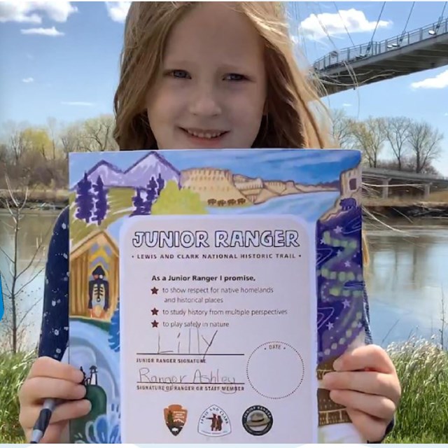
CERTIFICATE
OVERVIEW
Certificate. A colorful, casually drawn border, about an inch thick, depicts various scenes from the Lewis and Clark Expedition. The certificate is oriented vertically. It features a Junior Ranger pledge. Beneath, three lines give room for Junior Ranger to sign, a ranger or staff member to sign, and room to write the site visited. A dotted circle on the right side saves room for a date stamp. Logos, a website, social media information, and a mailing address are listed on the bottom.
IMAGES
Colorful drawn border with boats, northern lights over earth lodges, white cliffs along a river, mountains, and pacific northwest tribal lodge, and a lighthouse on rocky shores. National Park Service Logo. Lewis and Clark Trail Logo. Junior Ranger Logo.
TEXT.
Junior Ranger. Lewis and Clark National Historic Trail.
As a Junior Ranger, I promise to:
• Show respect for native homelands and historical places.
• Study history from multiple perspectives.
• Play safely in nature.
Space for junior ranger signature, park ranger or staff ranger signature, and place to write in site visited. Space write or stamp the date.
This Junior Ranger read along video narrates and audio describes the Lewis and Clark Trail Junior Ranger Certificate. Follow along on the back of your booklet, or turn on closed captions.