The Northern Colorado Plateau Network monitors key resources at Curecanti National Recreation Area, including vegetation.
NPS
Scientific research is key to protecting the natural and cultural wonders of our national parks. To make sound decisions, park managers need accurate information about the resources in their care. They also need to know how park ecosystems change over time, and what amount of change is normal. But park staff can’t do it alone.
Scientists with the Northern Colorado Plateau Network collect long-term data on Curecanti. They monitor key resources, like plant communities, soils, and the quality and quantity of water. They analyze the results and report them to park managers. Knowing how key resources are changing can provide managers with early warning of potential problems. It can also help them to make better decisions and plan more effectively.
Studying park vital signs is only part of the picture. Scientific research is also conducted by park staff, graduate students, and independent researchers. Because many parks prohibit activities that occur elsewhere, scientists can use the parks as "control" areas for determining the effects of these activities where they do occur. Especially in the American West, national park lands often serve as the best model for what a relatively undisturbed landscape looks like.
Locations:Black Canyon Of The Gunnison National Park, Curecanti National Recreation Area
Offices:Inventory and Monitoring Division, Natural Resource Stewardship and Science Directorate, Northern Colorado Plateau Inventory & Monitoring Network
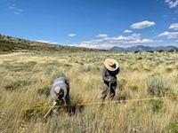
At Black Canyon of the Gunnison National Park and Curecanti National Recreation Area, long-term vegetation monitoring provides park managers with useful information for decision making on topics including changes in climate, grazing, and fire management. A recent report summarizes monitoring from 2011 to 2022 of vegetation and soil conditions provides management recommendations for their conservation.
Offices:Inventory and Monitoring Division, Natural Resource Stewardship and Science Directorate, Northern Colorado Plateau Inventory & Monitoring Network
Invasive exotic plants are one of the most significant threats to natural resources in the national parks today. To provide early warning of weed invasions, the Northern Colorado Plateau Network monitors target plants in park areas where they are likely to first establish: along roads, trails, and waterways. Find out what we've learned at Curecanti National Recreation Area.
Northern Colorado Plateau Network’s scientists use satellite observations of vegetation condition in Curecanti National Recreation Area with climate data over time to reveal how climate influences plant production and phenology. Knowing which of the wide range of 16 vegetation assemblages found in Curecanti are more or less sensitive to climate change can help managers understand what to expect over the next few decades, and plan for the changes coming their way.
Locations:Arches National Park, Black Canyon Of The Gunnison National Park, Bryce Canyon National Park, Canyonlands National Park, Capitol Reef National Park, Colorado National Monument, Curecanti National Recreation Area, Dinosaur National Monument, Fossil Butte National Monument, Natural Bridges National Monument, Pipe Spring National Monument, Zion National Parkmore »
Northern Colorado Plateau Network’s long-term landbird monitoring program provides habitat-based updates for bird population status and trends in the parks in the Northern Colorado Plateau. These inform scientists and managers about changes in bird populations and about the health of the habitats they depend on. Learn more about which species were detected in the network parks for the first time and which landbird populations were increasing or declining between 2005 - 2024.
Locations:Black Canyon Of The Gunnison National Park, City Of Rocks National Reserve, Craters Of The Moon National Monument & Preserve, Curecanti National Recreation Area, Grand Teton National Park, John Day Fossil Beds National Monument
Offices:Inventory and Monitoring Division, Upper Columbia Basin Inventory & Monitoring Network
Sagebrush, America’s most imperiled ecosystem, is half of what it once was. Aided by recent infrastructure funding, a dedicated community of scientists is racing to protect the best of what’s left.
Locations:Aniakchak National Monument & Preserve, Arches National Park, Big Bend National Park, Bighorn Canyon National Recreation Area, Bryce Canyon National Park, Canyonlands National Park, Capitol Reef National Park, Chaco Culture National Historical Park, Colorado National Monument, Curecanti National Recreation Area, Denali National Park & Preserve, Dinosaur National Monument, Gettysburg National Military Park, Glen Canyon National Recreation Area, Katmai National Park & Preserve, Lewis and Clark National Historical Park, Mesa Verde National Park, Navajo National Monument, Petrified Forest National Park, Pipe Spring National Monument, Rainbow Bridge National Monument, Springfield Armory National Historic Site, Valley Forge National Historical Park, Wrangell - St Elias National Park & Preserve, Yellowstone National Park, Yukon - Charley Rivers National Preserve, Zion National Parkmore »
Offices:Geologic Resources Division
Dinosaur fossils have been discovered at or are associated with at least 27 NPS units. Geographically, their finds are concentrated in the parks of the Colorado Plateau, but they have been found from central Alaska to Big Bend National Park in Texas to Springfield Armory National Historic Site in Massachusetts. The most famous site is the Dinosaur Quarry of Dinosaur National Monument, but a rush of new finds since the 1970s has greatly expanded our knowledge.
Locations:Acadia National Park, Agate Fossil Beds National Monument, Alibates Flint Quarries National Monument, Amistad National Recreation Area, Antietam National Battlefield, Apostle Islands National Lakeshore, Appalachian National Scenic Trail, Arches National Park, Assateague Island National Seashore, Aztec Ruins National Monument, Badlands National Park, Bandelier National Monument, Bent's Old Fort National Historic Site, Big Bend National Park, Big Cypress National Preserve, Big Hole National Battlefield, Big South Fork National River & Recreation Area, Big Thicket National Preserve, Bighorn Canyon National Recreation Area, Biscayne National Park, Black Canyon Of The Gunnison National Park, Blue Ridge Parkway, Bryce Canyon National Park, Buffalo National River, Cabrillo National Monument, Canyon de Chelly National Monument, Canyonlands National Park, Cape Cod National Seashore, Cape Hatteras National Seashore, Cape Lookout National Seashore, Capitol Reef National Park, Capulin Volcano National Monument, Carlsbad Caverns National Park, Casa Grande Ruins National Monument, Catoctin Mountain Park, Cedar Breaks National Monument, Chaco Culture National Historical Park, Chamizal National Memorial, Channel Islands National Park, Chattahoochee River National Recreation Area, Chesapeake & Ohio Canal National Historical Park, Chickasaw National Recreation Area, Chiricahua National Monument, Colorado National Monument, Congaree National Park, Coronado National Memorial, Cowpens National Battlefield, Crater Lake National Park, Craters Of The Moon National Monument & Preserve, Cumberland Island National Seashore, Curecanti National Recreation Area, Cuyahoga Valley National Park, Death Valley National Park, Delaware Water Gap National Recreation Area, Devils Postpile National Monument, Devils Tower National Monument, Dinosaur National Monument, Dry Tortugas National Park, Ebey's Landing National Historical Reserve, Effigy Mounds National Monument, El Malpais National Monument, El Morro National Monument, Everglades National Park, Fire Island National Seashore, Florissant Fossil Beds National Monument, Fort Bowie National Historic Site, Fort Larned National Historic Site, Fort Union National Monument, Fort Vancouver National Historic Site, Fossil Butte National Monument, Gettysburg National Military Park, Gila Cliff Dwellings National Monument, Glacier National Park, Glen Canyon National Recreation Area, Golden Gate National Recreation Area, Golden Spike National Historical Park, Grand Canyon National Park, Grand Canyon-Parashant National Monument, Grand Portage National Monument, Grand Teton National Park, Grant-Kohrs Ranch National Historic Site, Great Basin National Park, Great Sand Dunes National Park & Preserve, Great Smoky Mountains National Park, Guadalupe Mountains National Park, Gulf Islands National Seashore, Hagerman Fossil Beds National Monument, Hopewell Culture National Historical Park, Hovenweep National Monument, Indiana Dunes National Park, Isle Royale National Park, Jean Lafitte National Historical Park and Preserve, Jewel Cave National Monument, John Day Fossil Beds National Monument, John Muir National Historic Site, Joshua Tree National Park, Juan Bautista de Anza National Historic Trail, Katahdin Woods and Waters National Monument, Lake Mead National Recreation Area, Lake Meredith National Recreation Area, Lake Roosevelt National Recreation Area, Lassen Volcanic National Park, Lava Beds National Monument, Lewis & Clark National Historic Trail, Little Bighorn Battlefield National Monument, Lyndon B Johnson National Historical Park, Mammoth Cave National Park, Marsh - Billings - Rockefeller National Historical Park, Mesa Verde National Park, Mississippi National River & Recreation Area, Missouri National Recreational River, Mojave National Preserve, Montezuma Castle National Monument, Mount Rainier National Park, Mount Rushmore National Memorial, Muir Woods National Monument, Natchez Trace Parkway, National Capital Parks-East, Natural Bridges National Monument, Navajo National Monument, New River Gorge National Park & Preserve, Niobrara National Scenic River, Noatak National Preserve, Obed Wild & Scenic River, Olympic National Park, Oregon Caves National Monument & Preserve, Organ Pipe Cactus National Monument, Ozark National Scenic Riverways, Padre Island National Seashore, Pecos National Historical Park, Petrified Forest National Park, Petroglyph National Monument, Pictured Rocks National Lakeshore, Pipe Spring National Monument, Point Reyes National Seashore, Redwood National and State Parks, Rio Grande Wild & Scenic River, Rock Creek Park, Rocky Mountain National Park, Saguaro National Park, Saint Croix National Scenic Riverway, Salinas Pueblo Missions National Monument, Sand Creek Massacre National Historic Site, Santa Monica Mountains National Recreation Area, Scotts Bluff National Monument, Sequoia & Kings Canyon National Parks, Shenandoah National Park, Sleeping Bear Dunes National Lakeshore, Sunset Crater Volcano National Monument, Tallgrass Prairie National Preserve, Theodore Roosevelt National Park, Timpanogos Cave National Monument, Timucuan Ecological & Historic Preserve, Tonto National Monument, Tule Lake National Monument, Tule Springs Fossil Beds National Monument, Tumacácori National Historical Park, Tuzigoot National Monument, Upper Delaware Scenic & Recreational River, Valles Caldera National Preserve, Voyageurs National Park, Walnut Canyon National Monument, Washita Battlefield National Historic Site, Whiskeytown National Recreation Area, White Sands National Park, Wilson's Creek National Battlefield, Wind Cave National Park, Wupatki National Monument, Yellowstone National Park, Yosemite National Park, Yucca House National Monument, Zion National Parkmore »
Across the US, changes in water availability are altering which plants grow where. These changes are evident at a broad scale. But not all areas experience the same climate in the same way, even within the boundaries of a single national park. A new dataset gives park managers a valuable tool for understanding why vegetation has changed and how it might change in the future under different climate-change scenarios.
Each park-specific page in the NPS Geodiversity Atlas provides basic information on the significant geologic features and processes occurring in the park. Links to products from Baseline Geologic and Soil Resources Inventories provide access to maps and reports.
Locations:Arches National Park, Black Canyon Of The Gunnison National Park, Bryce Canyon National Park, Canyonlands National Park, Capitol Reef National Park, Curecanti National Recreation Area, Dinosaur National Monument, Fossil Butte National Monument, Natural Bridges National Monument, Pipe Spring National Monument, Zion National Parkmore »
Offices:Inventory and Monitoring Division, Natural Resource Stewardship and Science Directorate, Northern Colorado Plateau Inventory & Monitoring Network
Because birds can be sensitive to habitat change, they are good indicators of ecosystem integrity. The Northern Colorado Plateau Network partners with the University of Delaware to assess breeding-bird species trends in three different habitats: low-elevation riparian, pinyon-juniper, and sage shrubland. Find out which species were increasing and declining at network parks as of 2023.
Locations:Arches National Park, Black Canyon Of The Gunnison National Park, Bryce Canyon National Park, Canyonlands National Park, Capitol Reef National Park, Colorado National Monument, Curecanti National Recreation Area, Dinosaur National Monument, Fossil Butte National Monument, Natural Bridges National Monument, Zion National Parkmore »
Birds of the desert southwest, a climate-change hotspot, are among the most vulnerable groups in the US. To help park managers plan for those changes, scientists evaluated the influence of water deficit on landbird communities at 11 national parks in Utah and Colorado. The results will help land managers to focus conservation efforts on places where certain species are most vulnerable to projected climate changes.