Showing results 1-10 of 109
- Cuyahoga Valley National Park
Boston Store Trailhead
- Type: Place
- Locations: Cuyahoga Valley National Park
The Village of Boston grew up alongside a canal on the east side of the Cuyahoga River and a railroad on the west side of the river. Boston Store Trailhead provides limited mobility parking on the east side. Use it to access the Ohio & Erie Canal Towpath Trail and refreshments at Boston Store. This small trailhead does not accommodate over-sized vehicles.
- Chesapeake Bay
St. Clement’s Island Museum
- Type: Place
- Locations: Chesapeake Bay

Discover the St Clement’s Island Museum where Maryland's founding story comes to life. Explore exhibits that highlight the rich history of the Piscataway People and early settlers. Stand on the historic island where the first English settlers landed in 1634, accessible by water taxi. Experience the beauty of the Potomac River and immerse yourself in the culture that shaped the Chesapeake Bay. Don’t miss the chance to learn and explore this unique site in St. Mary’s County.
- Grand Teton National Park
Jenny Lake Pathway Hub
- Type: Place
- Locations: Grand Teton National Park
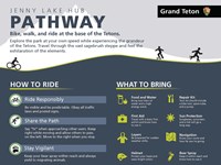
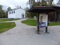
The Jenny Lake Pathway Hub is the most northern point of the multi-use pathway. Read our informational sign about biking and use the bike rack to store your bike while you explore the Jenny Lake area.
- Grand Teton National Park
Gros Ventre Pathway Hub
- Type: Place
- Locations: Grand Teton National Park
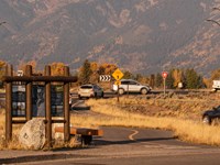
The Gros Ventre Pathway Hub is one of many locations where you can start or end your bike ride along the multi-use pathway. Enjoy over 20 miles of paved pathway in Grand Teton.
- Type: Place
- Locations: Cuyahoga Valley National Park, First Ladies National Historic Site

The Ohio and Erie Canalway National Heritage Area spurred economic development across the nation by creating an inland connection for goods from Lake Erie to the Ohio River, known as the heartland of America to the eastern seaboard. This development fueled westward expansion, a national market economy, a booming industrial manufacturing sector, and the settlement of towns, villages, and cities along the canal.
- Mount Rainier National Park
South Puyallup Trailhead
- Type: Place
- Locations: Mount Rainier National Park
Hike or bike Westside Road to reach the South Puyallup Trailhead.
- Grand Canyon National Park
Canyon Adventures Bike Tours & Café —Visitor Center Plaza
- Type: Place
- Locations: Grand Canyon National Park

Canyon Adventures Bike Tours & Café offers bicycle, eBike, stroller, and wheelchair rentals, as well as a full espresso bar and grab-and-go sandwiches, salads, pastries, drinks, and more. Hours: 8 am to 5 pm daily. Located in the South Rim Visitor Center's Plaza, adjacent to Parking Lot 4. During spring, summer and fall, guided bicycle tours are available. Some outdoor accessories are also on sale, like hats, sunglasses, water bottles and trekking poles.
- Cuyahoga Valley National Park
Lock 29 Trailhead Information
- Type: Place
- Locations: Cuyahoga Valley National Park

The Ohio & Erie Canal made Peninsula a busy industrial town and popular overnight stop for canal travelers. Today visitors can stroll through the historic downtown, shop, and dine. Lock 29 Trailhead is a popular, often crowded access point for the village, Towpath Trail, Cuyahoga Valley Scenic Railroad, and Cuyahoga River Water Trail. On the towpath, travel 2.3 miles north to the village of Boston. About a mile south is Deep Lock and connecting trails to old stone quarries.
- Point Reyes National Seashore
Coast Trailhead
- Type: Place
- Locations: Point Reyes National Seashore

The Coast trailhead is a popular place to start an easy hike, bike, or horseback ride to the beach. It meanders through creek-side habitat before going by wetlands as you approach the ocean. The trailhead is located along Laguna Road, approximately 15 minutes by car from the Bear Valley Visitor Center.
- Mount Rainier National Park
Westside Road: Dry Creek Trailhead
- Type: Place
- Locations: Mount Rainier National Park
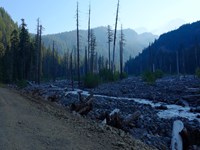
The majority of Westside Road is closed to vehicles. Park at Dry Creek to hike or bike the road and access other trails on the western side of Mount Rainier National Park.
Last updated: February 7, 2019