Coastal and Marine Ecosystems

Alaska has nearly 34,000 miles of shoreline—more than all of the lower 48 U.S. combined—and 3,095 miles are protected within parks. The ocean is an integral part of Alaska's aquatic and terrestrial ecosystems, weather, economy, history, and culture. As changes occur and pressures on the ocean's resource increase, it is more important than ever to monitor, understand, minimize impact, and preserve resources associated with oceans and coastline.
When a massive seabird die-off coincided with an extreme marine heatwave, we knew the ocean ecosystem had dramatically changed. We found every level of the food web was altered.

Check out more science and outreach about marine and coastal resources with the Ocean Alaska Science and Learning Center, and more about oceans throughout the National Park Service. Keep up to date with the latest research on oceans and coastal research through Currents, Glacier Bay National Park and Preserve's science blog. Also, check out the Arcitc-Pacific Ocean Stewardship Strategy.
coastal and marine habitats
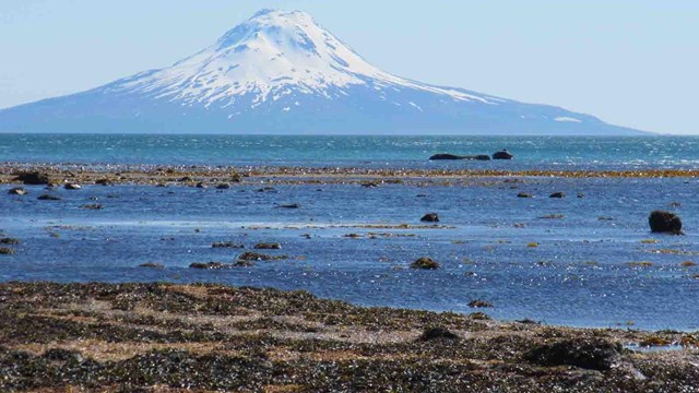
Coastal and Marine Habitats

The coastal and marine environments have a wide range of habitats for marine mammals, birds, fish, invertebrates, and more.

coastal wildlife
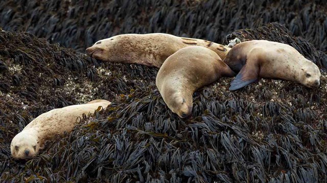
Marine and Coastal Wildlife

Alaska has amazing diversity of marine and coastal wildlife.

a curious seal pops out of the icy waters
Marine and Coastal Issues of Concern

Learn more about issues of concern related to Alaska's coasts and marine ecosystems
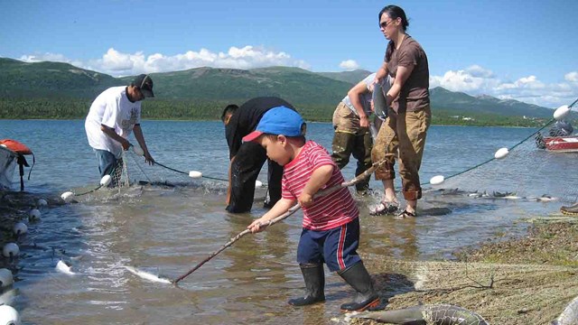
Human Connections
Human Connections

For thousands of years people have lived along the coast and depended on coastal and marine resources. Our relationship continues today.

Showing results 1-8 of 8

  • A map of a warm water mass in the northern Pacific Ocean, known as the Blob.

    The Blob is a mass of warm water in the north Pacific Ocean that is linked to changes in climate and ocean ecosystems. The ocean is changing; what can we expect in the future?

  • Common murres poised on the side of a cliff. NPS photo

    Resource brief summarizing data collection efforts and need for consisted research on Alaska's coastal birds.

    • Locations: Glacier Bay National Park & Preserve
    park visitors gather on the bow of a cruise ship over glassy waters

    Understanding how the presence of cruise ships may affect humpback whales is a research priority for managers of Glacier Bay National Park and Preserve. An observer boarded cruise ships in 2008 and 2009 to docu-ment how often and how close ships encountered whales as ships transited the park and adjacent waters.

    • Locations: Aniakchak National Monument & Preserve, Bering Land Bridge National Preserve, Cape Krusenstern National Monument, Denali National Park & Preserve, Gates Of The Arctic National Park & Preserve,
    A spawning salmon struggles to get back into the water.

    ANILCA establishes the largest scientific laboratory...ever!

  • A rocky cliff with nesting seabirds.

    When a massive seabird die-off coincided with an extreme marine heatwave, we knew the ocean ecosystem had dramatically changed. We found every level of the food web was altered. Check out this story map about changes to marine environments in Alaska and beyond.

    • Locations: Bering Land Bridge National Preserve, Cape Krusenstern National Monument, Glacier Bay National Park & Preserve, Katmai National Park & Preserve, Kenai Fjords National Park,
    A researcher examines a dead glaucus gull on a beach.

    Seabirds and marine mammals along Alaska's coastline have been experiencing unusually large and consistent die-offs for the past several years, in conjunction with warming ocean temperatures. Researchers want to know if harmful algal blooms, typically associated with warmer climates, are playing a role in these deaths.

    • Locations: Bering Land Bridge National Preserve, Cape Krusenstern National Monument
    Caribou skulls in an Arctic valley

    The Arctic Council and its working groups provide a forum through which NPS scientists and managers can share information and learn from a wide array of colleagues and Arctic residents that are coping with similar challenges.

    • Locations: Bering Land Bridge National Preserve, Cape Krusenstern National Monument
    seal along the coast

    The Arctic coastal parks are currently facing a new set of threats brought about primarily by climate change and associated economic trends. Remote parks, people, and cultures are finding themselves increasingly in the midst of complex and novel situations.

Learn more about Alaska's coastal and marine resources

Showing results 1-5 of 5

    • Type: Article
    • Locations: Big Cypress National Preserve, Cape Cod National Seashore, Chesapeake Bay, Fort Matanzas National Monument, Kenai Fjords National Park, Olympic National Park
    • Offices: Geologic Resources Division
    sunset over wetlands

    Estuaries are buffer zones between river (freshwater) and ocean (saltwater) environments that are affected by tidal oscillations.

    • Type: Article
    • Locations: Lake Clark National Park & Preserve
    • Offices: Ocean Alaska Science and Learning Center
    Researchers sample razor clams on the coastline of Lake Clark National Park and Preserve.

    Sea otters, once hunted to near extinction in the northern Pacific Ocean, may be returning to Lake Clark National Park and Preserve’s coast. What would that mean for the ecosystem?

    • Type: Article
    • Locations: Big Cypress National Preserve, Cape Cod National Seashore, Chesapeake Bay, Fort Matanzas National Monument, Kenai Fjords National Park, Olympic National Park
    aerial view of island and reef

    Our national parks contain diverse coastal landforms: high-energy rocky shorelines of Acadia National Park, quiet reef-lagoons within War in the Pacific National Historic Park, and the white sandy beaches of Gulf Islands National Seashore. Coastal landforms are, or have been, affected to some degree by the direct or indirect effects of waves, tides, and currents, and may extend inland for many miles.

    • Type: Article
    • Locations: Kenai Fjords National Park
    forested mountains overlooking a lagoon

    The seafloor sediments of deep coastal lagoons within Kenai Fjords National Park could provide a millennial-scale record of local environmental change and a timeline of catastrophic events such as volcanic eruptions, glacial advances, and tsunamis. Understanding how the park’s coastline responded to past tectonic and climate-driven changes should provide valuable context to ongoing and future conditions.

    • Type: Article
    • Locations: Bering Land Bridge National Preserve, Cape Krusenstern National Monument
    people near two yellow tents in a tree-less expanse of tundra

    Bering Land Bridge National Preserve and Cape Krusenstern National Monument exhibit a wide variety of coastal landforms including barrier lagoons, tundra bluffs, accreting spits, and beach ridge complexes; all home to vulnerable fauna, flora, and avian communities; internationally significant archaeological, historic, and ethnographic resources; and unique paleoecological and fossil records. Coastal erosion and a changing climate pose a threat to these areas.

Last updated: July 7, 2021