NPS Data
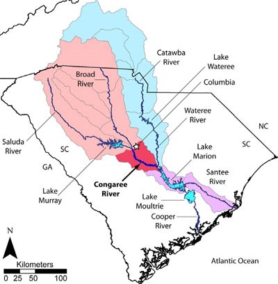
The Congaree River (red watershed) is formed by the confluence of the Saluda and Broad Rivers (pink watersheds) in central South Carolina near Columbia (white star). The Congaree converges with the Wateree (blue watersheds) to form the Santee River (purple watersheds), which flows to the Atlantic Ocean. Although the Santee River is one of the dominant river basins of the Atlantic Seaboard, much of the modern, natural discharge is currently diverted through Lake Moultrie to the Cooper River.
Measurements of Watershed Area are instructive:
- The Congaree River Watershed area for the gage on the Congaree River at the Western Boundary Road
-
- 8,290 square miles (21,471 square kilometers)
- The Wateree River Watershed area for the gage just southeast of Eastover
-
- 5,590 square miles (14,478 square kilometers)
- The Santee River Watershed area at Trezvant's landing (i.e., at the top of Lake Marion - this is basically the Watershed for Congaree National Park plus a very few, small streams that feed in below the park)
-
- 14,100 square miles (36,519 square kilometers)
Last updated: October 10, 2014
