|
Tomales Point (aka Pierce Point) is located at the northern end of Point Reyes National Seashore. The Tomales Point area is a popular destination for visitors wishing to view tule elk, birds, and wildflowers. The historic Pierce Ranch offers a glimpse into the early dairy ranching days on the peninsula. A short 0.4-mile (0.6-km) trail leads down to the beautiful McClures Beach. The 9.7-mile (15-km) round-trip Tomales Point Trail leads along the ridge crest of a narrow peninsula, offering spectacular views of Tomales Bay and Bolinas Ridge to the east, Bodega Bay to the north, and the coastline of the Point Reyes peninsula stretching to the south. 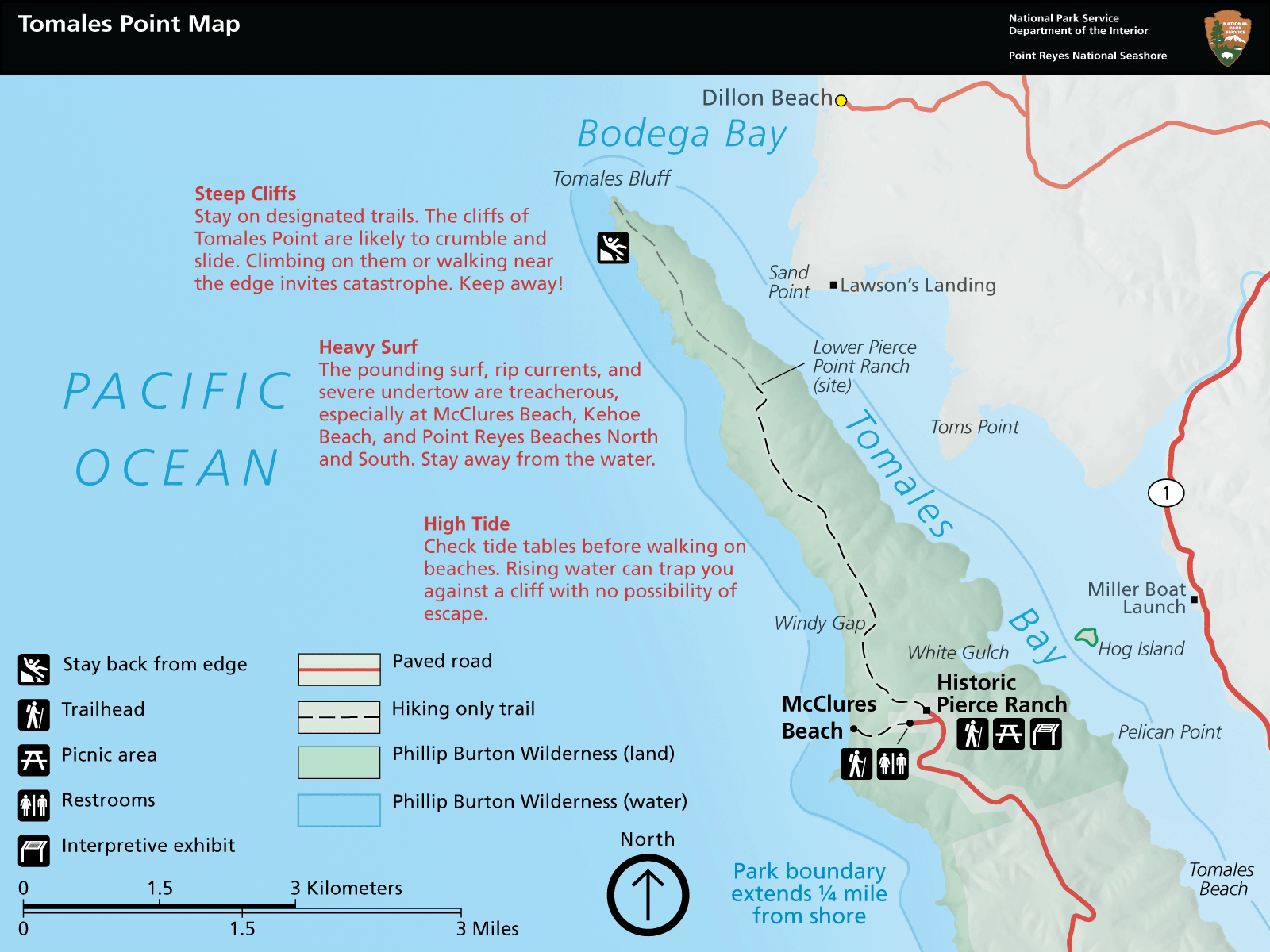
Come Prepared


The DriveTomales Point is located at the northern-most end of the Point Reyes peninsula. From the Bear Valley Visitor Center, drive northwest ~2 miles (~3 km) on Bear Valley Road before turning left on Sir Francis Drake Boulevard. After driving another 5.6 miles (9 km), turn right at the Y signed for "Tomales Bay State Park" and "Pierce Point Ranch." Follow Pierce Point Road 9 miles (14.5 km) to the parking lot at Pierce Ranch and the Tomales Point Trailhead. To get to McClures Beach, turn left just before entering the ranch parking lot and descend the hill 0.2 miles (0.3 km) to the McClures Beach parking lot. Sir Francis Drake Boulevard and Pierce Point Road are windy and slow-going, so allow thirty-five minutes to drive the 16.6 miles (~26.5 km) from the Bear Valley/Olema/Point Reyes Station area to the Tomales Point parking lot (one hour and ten minutes round-trip), not including any time you will spend in the area. Allow one hour and thirty-five minutes for the drive (three hours and ten minutes round-trip) from the Santa Rosa area, northwest San Francisco, or the northern East Bay. Many visitors spend at least an hour or two in the Tomales Point area. RVs and TrailersIf you are traveling with a trailer or are driving an RV towing a passenger vehicle, consider unhitching at the bus/RV/trailer-only parking lot at Bear Valley and taking only the passenger vehicle for the drive out to Tomales Point and other areas of the park. Overnight parking/camping in RVs and trailers is prohibited throughout Point Reyes National Seashore. ParkingParking is very limited, particularly in the afternoon. Please observe all "No Parking" signs. If you park along the Pierce Point Road south of the parking lot, ensure that no part of your parked vehicle is on the pavement in order to allow other vehicles to safely pass. Please park perpendicular to the road where possible. Be aware that the shoulders along Pierce Point Road are often soft during the winter and spring and vehicles have become stuck in the mud when their owners attempted to park along the road. Parking Lot McClures Beach Trailhead Parking Lot
Live Status
The McClures Beach Trailhead Parking Lot is a paved parking lot that can accommodate ~25 vehicles. It is at the west end of a spur road heading downhill and to the west from the Tomales Point Traihead/Pierce Ranch parking lot. The McClures Beach Trailhead is located at the west end of the lot. A vault toilet building is at the northeast corner of the lot.
Parking Fee No parking or entrance fees are charged at Point Reyes National Seashore. Cost: $0.00 Amenities
Image Gallery
Parking Lot Tomales Point Parking Lot
Live Status
A dirt parking lot at the north end of Pierce Point Road that can accommodate 20 vehicles. On busy weekends and holidays, the parking lot may be full by 10 am. If you park along the Pierce Point Road south of the parking lot, please observe all "No Parking" signs and ensure that no part of your parked vehicle is on the pavement in order to allow other vehicles to safely pass. The Tomales Point Parking Lot is approximately 35 minutes by car from the Bear Valley Visitor Center via Pierce Point Road.
Parking Fee No parking or entrance fees are charged at Point Reyes National Seashore. Cost: $0.00 Amenities
Image Gallery
AccessibilityA flat trail provides access to a self-guided tour of the ranch complex. Panels have ADA-compliant fonts. A telephone in the lower parking lot is accessible. Stay on designated trailsThe only official trails in the Tomales Point area are the Tomales Point Trail and McClures Beach Trail, shown in the map to the right (or above, if you are viewing this page on a small screen). Hiking along the bluff tops can be unsafe and is not recommended. Stay away from cliff edges. Loose soil and/or rock can give way suddenly and you may fall. Do not climb cliffs. The tule elk seem to be accustomed to visitors walking along the Tomales Point Trail, but tend to react negatively to visitors they encounter off-trail. Please reduce the chance of disturbing the elk by staying on the official trail. Visitors walking off of official trails and paths trample vegetation, which may lead to the death of the trampled plants. Over time, as more and more visitors use a route, it starts to look more and more like an official trail, and more and more visitors use it, resulting in a feedback loop that makes the "trail" look "official." However, these "social paths" tend to exacerbate erosion and harm threatened and endangered species. These paths also can lead to locations where visitors may be more at risk to injury, endangering themselves and any potential rescuers. 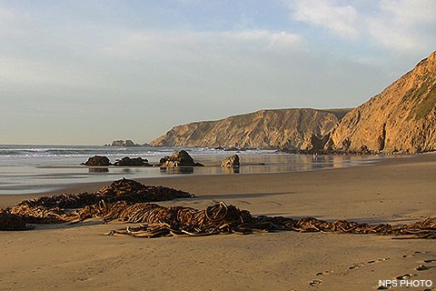
McClures BeachA short, moderately steep 0.4-mile (0.6 km) hike leads down to a beautiful beach in a small cove with intense surf that is surrounded by rocky cliffs. The intense surf crashing on the rocks at either end of the beach add to the drama and danger. It is tempting to venture around the southern corner to explore the adjacent beach, but use caution! This area can only be safely accessed during the outgoing low tide. While referenced in many books and websites as a good location to find tidepools, tidepoolers have lost their lives here when sneaker waves have struck them. Please visit our Safety Issues Associated with Beaches page for more information. 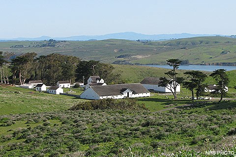
Historic Pierce RanchEstablished in 1858, Pierce Ranch (aka Pierce Point Ranch) was the largest of four independent ranches on the the Point Reyes peninsula in the late 1800s. The Shafter brothers sold a 2,200-acre tract of land on the end of Tomales Point to Solomon Pierce for $7,000 in 1858. Pierce Ranch excelled in the production of the finest quality of butter, as indicated by Goldberg, Bowen, and Company—a famous San Francisco fine food purveyor—which purchased the entire butter production of Pierce Ranch during late 1800s. The Point Reyes region ranches were, as a group, considered to be the best dairy ranches among the 300 in the state as of 1900, and Pierce Ranch was at the top among the Point Reyes ranches in the quality of its product. In recognition of its importance, it was written up in 1878 and again in 1880 as an outstanding example of a dairy ranch. The Pierce Ranch ceased operations in 1973. Beginning in 1980, the National Park Service invested in the rehabilitation of the ranch core, citing it as the best example of a west Marin dairy ranch from the 1800s. Among the many ranches of the Point Reyes peninsula and of the nearby Olema Valley, Pierce Ranch is the one with the greatest degree of integrity of early buildings in its physical complex. Pierce Ranch is probably the least altered, least modernized, physical complex of ranch buildings in the area. Part of the ranch's main house dates to 1856, making it the oldest surviving ranch house in the Point Reyes region, if not in the whole coastal section of Marin County. Pierce Ranch was added to the National Register of Historic Places in 1985, and was subsequently opened to the public as an interpretive site. Visitors are welcome to walk through the ranch complex, where interpretive signs describe the history and function of the various buildings. Historic features include the main house, a schoolhouse, a blacksmith shop, barns, dairy houses, and many other structures. Please note: The main house currently serves as a residence for park employees. Please respect the privacy of the residents. 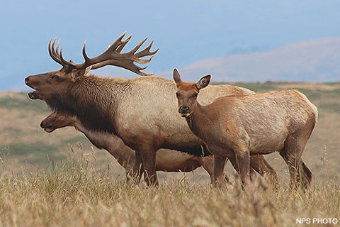
Tule ElkTule elk once inhabited the grasslands of the Point Reyes peninsula and the Olema Valley, as well as other grasslands within Marin County. They were the dominant grazers on these lands until their local extirpation in the 1850s. State and Federal legislation in the early 1970s authorized the California Department of Fish and Game (now the Department of Fish and Wildlife), in cooperation with U.S. Fish and Wildlife Service and the National Park Service, to reintroduce the extirpated tule elk to Tomales Point. In 1976, Congress authorized the creation of the Point Reyes Wilderness (renamed in honor of Phillip Burton in 1985), incorporating the decommissioned cattle ranch as habitat for the reintroduction of tule elk. Ten elk (eight females and two males) were transplanted from an existing reintroduced herd in the San Luis National Wildlife Refuge near Los Baños to a 2,600-acre fenced enclosure on Tomales Point in 1978. Since then, the herd has become one of the largest populations of tule elk in California. In 2019, the National Park Service increased the size of the reserve to 2,900 acres. Please visit our Viewing Tule Elk page for elk watching tips and our Tule Elk page for more information about this species. 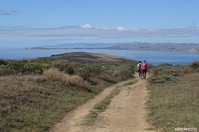
Tomales Point TrailThe Tomales Point Trail offers panoramic views of the Pacific Ocean, Bodega Bay, and Tomales Bay as one potentially hikes 9.4 miles (15 km) round-trip to the northern end of the Peninsula. The first three miles of this trail are maintained and follows the route of an old ranch road as it travels along the crest of the ridge. The first mile of the trail is fairly level and broad, with views looking west over the Pacific Ocean. This is an opportune section of the trail to be on for sunset (so long as fog doesn't obscure the view). One can catch the sun setting "into" the ocean and still have enough twilight to walk back to one's vehicle before dark. At the one-mile (1.6-km) mark is Windy Gap at the head of White Gulch. This is a good location from which to view elk gathered at a perennial spring in the gulch below. Looking beyond White Gulch, one has a view of Hog Island in Tomales Bay. Continuing north on the trail, one begins to ascend along the ridge crest to the highest location along the trail, located approximately 2.25 miles (3.6 km) from the trailhead. If you don't want to sweat much on the return hike, turn around here. Beyond this "peak", the trail descends rather steeply over the next 0.75 miles (1.2 km). But, if you are willing to proceed, you will soon arrive at a stock pond at the site of the Lower Pierce Ranch. If you have yet to see elk, you'll likely see some here. Turn around here if you desire a 6-mile (10 km) round-trip hike. Beyond the Lower Pierce Ranch site, the trail is no longer maintained and becomes sandy. In places, it can be challenging to recognize which path to follow among the bush lupine, but the myriad paths tend to reconnect and ultimately merge into one path along the last half mile (0.8 km) of the "trail." Please stay on the main trail and away from the cliff tops. Bluffs along the California coast are inherently unstable. They are prone to crumbling and sliding, especially in wet weather. It is very dangerous to climb or walk along the edge of cliffs. 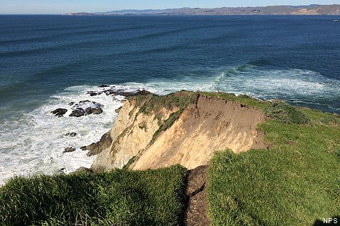
Collapse of Bluff near Tomales PointAs an example of how sea cliffs are hazardous, in January 2017, part of the bluff at the northern end of Tomales Point collapsed. As a result, a section of the Tomales Point Trail is no more. If you plan on hiking to Tomales Point, be aware that additional sections of the cliff may collapse. Small cracks are present in the ground, some several feet from the edge. If you are hiking anywhere that brings you near cliffs, please be mindful of the hazards. Be aware of your surroundings and stay back from the edge. Many of the cliffs around Point Reyes are unstable and prone to collapse. Thank you to the visitor that reported this collapse. Similar to the fissure that formed on top of Arch Rock, visitors discovered these hazards before park staff did. You can help park staff better protect park visitors by contacting the park's Dispatch at 415-464-5170 or by sending us an email if you find anything that looks hazardous in the park. |
Last updated: August 13, 2024
