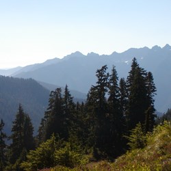
Description
Ecosystem Type: Montane forest, subalpine forest, subalpine meadow
Trail Tread Types: Primitive/Unmaintained
General Elevation Trend: Steep
Level of Difficulty: Difficult
Distance: ~23 miles from Three Lakes to Low Divide
Elevation Change: 3,350 feet to 5,400 feet. Trailhead is at 500 feet.
Best Season: Late July through October
Connecting Trails: North Fork Quinault River Trail, Elip Creek Connector Trail, Big Creek Trail, Three Lakes Trail, Irely Lake Trail
Stock: Closed to stock
Check Current Trail Conditions
Trail Guide
Three Lakes ⇒ Three Prune
~4.4 miles
Heading northeast past the Three Lakes camping area, the Skyline Primitive Trail contours uphill on the forested slope for approximately 1.5 miles before passing Reflection Lake below the trail to the east. The trail continues past a series of small meadows, ponds and streams before becoming forested again as it gains a small pass from which the first views of Mount Olympus can be glimpsed with clear skies. One and a half miles after the junction with the Elip Creek Connector Trail, the Skyline Primitive Trail enters the Three Prune camping area (3 sites). The main camping area is adjacent to an old gnarled tree that prominently stands out in a surrounding meadow. This campsite requires bear canisters as the appropriate food storage method due to a lack of suitable trees to hang from. Be aware that the small streams that cross on either side of the Three Prune camping area are the last reliable water sources until Kimta Peak Basin which is 5.2 miles further on.
Three Prune ⇒ Kimta Peak
~5.2 miles
*There are no reliable water sources between Three Pune and Kimta Peak Basin*
The trail narrows and steepens as it continues north past Three Prune. This forested section follows the ridgeline toward the Kimta Peak Basin, starting out on the eastern side of the ridge above Alta creek drainage and occasionally crossing over to the west, where magnificent views of the lower Queets Valley are occasionally revealed.
Kimta Peak ⇒ Lake Beauty Trail Junction
~5.6 miles
After passing above the small seasonal creek in Kimta Peak Basin the trail contours eastwards towards Promise Creek Pass. The side-hilling in this section is steep, loose and taxing; extra care should be taken as the footing is often a bit unstable. Upon gaining the pass, the trail ascends to the north and works through an open, rocky depression dotted with small knolls and narrow ravines. Rock cairns aid in navigating through this ~1 mile alpine area and help connect the segments of trail between rocky outcrops and ravines. Eventually the trail enters back into the sub-alpine forest, crosses the ridge at Hee Haw Pass and gradually continues to climb through meadows and scree slopes to Lake Beauty Pass. A 0.3 mile side trail leads 400ft down to the Lake Beauty campsite where bear canisters are the required food storage method. Idyllic Lake Beauty sits perched in a subalpine bowl with front and center views of the southern flanks of Mt. Olympus and further glimpses into the heart of the Olympics.
Lake Beauty Trail Junction ⇒ North Fork Quinault River Trail Junction
~7.6 miles
Continuing through subalpine forested sections, the trail contours north-eastward before descending 1000' to cross Seattle Creek; passing through a number of steep side streams and ravines along the way. The trail rapidly ascends back up 800ft on switchbacks and contours south through a series of benches dotted with subalpine meadows and clearings. The craggy south face of Mt Noyes and slopes of Mt Seattle loom above. Entering back into a forested section, the trail descends on switchbacks and crosses two rocky gullies before reaching the junction with the North Fork Quinault River Trail. Continue northeast on the trail a short distance to reach the Low Divide camping area.


