Description
Ecosystem type: Rain forest river valley
Trail tread types: Maintained
General elevation trend: Moderate
River crossings: River ford required at Wild Rose Creek, Elip Creek and 16-Mile. These crossings can be hazardous during high water.
Unique features: Old-growth rain forest
Level of difficulty: Moderate
Distance: 16 miles to Low Divide
Elevation change: 519 feet to 3,602 feet
Best Season: May through September (upper portion of the trail is usually snow covered through late June)
Connecting Trails: Elip Connector Trail, Skyline Primitive Trail
Stock: Allowed. See Stock Use to check regulations.
Trail Guide
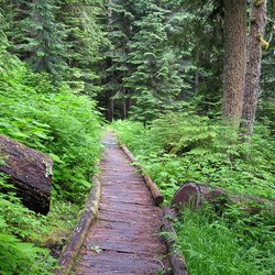
This moderately challenging trail from the North Fork of the Quinault River Trailhead to Low Divide is 16 miles and involves creek/river crossings that may become hazardous or impassable during periods of heavy rain or snowmelt. Dense stands of ancient Douglas fir, Sitka spruce, Western redcedar, and Western hemlock cloak the valley floor in the lower elevations and several scenic side creeks are encountered along the way. American black bears and Roosevelt elk also roam the valley and can be a highlight of a trip. For experienced parties looking for even more of a challenge; loop options exist via the Three Lakes Trail, Elip Connector, and/or Skyline Primitive Trail.
North Fork Trailhead ⇒ Wolf Bar
~2.5 miles
The first mile is relatively flat, making way through ferns and salmon berry brush before closely following the river for a bit, offering early glimpses up valley toward Mt Zindorf. A beautiful stand of Bigleaf maples and Western redcedars growing over an old, rocky creek bed lies about half way to Wolf Bar. Wolf Bar camp has 5 campsites at the forests edge with the option to follow Leave-No-Trace camping out on the river/gravel bar. There is no longer a usable bear wire at Wolf Bar; parties should bring enough rope to hang their food 12 feet up and 10 feet from the base of a tree or carry a park approved animal resistant food container (bear canister) to be able to store the food and scented items.
Wolf Bar ⇒ Elip Creek
~4 miles
From Wolf Bar to Elip Creek the trail makes short, but steep ascents and descents as it avoids minor washouts and climbs around small gorges of the river. Halfway House Camp (2 sites) is situated directly off the trail 2.6 miles up valley from Wolf Bar. Wild Rose Creek and Elip Creek are both fords and can be challenging with turbulent water during heavy rain and peak snowmelt. Elip Creek has 4 campsites situated on the north side of the creek, although the privy is located on the south side. There is no longer a bear wire at Elip Creek.
Elip Creek ⇒ Sixteen Mile
~5.7 miles
*Under summer conditions, the Sixteen Mile crossing of the North Fork is normally knee to thigh deep and swift. The crossing can become hazardous/impassable during heavy rainfall or snowmelt.
Leaving Elip Creek camp the Elip Connector Junction is immediately reached and branches off giving access to Three Lakes and the Skyline Trail for those who wish to make the steep 2300' ascent. Continuing up the North Fork the trail traverses spectacular old growth forest with scenic bridged crossings of Three Prune, Stalding, and Kimta Creeks. Trapper Shelter is reached 1.6 miles from Elip Creek and is for day and emergency use only, 2 small campsites are located behind the shelter along with a privy. Approaching 12 mile flat, the steep flanks of Mount Lawson come into view. Minor trail damage has occurred in this area and a short section with steep drop offs should be navigated with caution. Once down at 12 mile flat, one last climb takes you above yet another gorge and arrives you at the Sixteen Mile crossing. Sixteen Mile camp(4 sites) is located on the opposite bank in the forest.
Sixteen Mile ⇒ Low Divide
~3.5 miles
The trail leaves Sixteen Mile just past the privy and begins the strenuous climb to Low Divide. The trail is loose and narrow at times and care should be taken around these areas. A bridge spans Christie Creek before reaching the final switchbacks heading up to the lovely forested meadows of Low Divide at 3,600'. An unbridged creek usually has to be forded just prior to reaching Skyline PrimitiveTrail junction and the periodically staffed Low Divide Ranger Cabin is just a short stroll away. Three campsites are located within eye sight of the Ranger Cabin, and another group of two campsites are a further 1/4 mile beyond. The sign for Low Divide is located beyond these camps. The way trail up to Martin's Park takes off around the southern end of Lake Margaret. Camping within the Lake Margaret or Lake Mary vicinity is prohibited.


