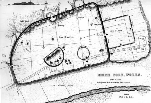
Squier & Davis, c.1848 THIS IS NOT where the park visitor center is located. Start your visit at the Hopewell Culture National Historical Park Mound City Group Visitor Center located at 16062 State Route 104, Chillicothe, OH 45601. There you may talk to Park Rangers, view our interpretive film, and pick-up Junior Ranger activities every day of the week.Hopewell Mound GroupTwo thousand years ago, people of an advanced culture gathered here to conduct religious rituals and ceremonies related to their society. At this site, they built an enormous earthwork complex enclosing 55.34 hectares (about 130 acres). An earthen wall extended for over four kilometers (over 2 miles), surrounding an immense sacred space that included 29 burial mounds. Astounding quantities of finely crafted art made of exotic materials were buried here as part of elaborate mortuary ceremonies. 
Squier & Davis 1848 New to ScienceThe culture discovered at this site was new to the science of archeology in the late 1800’s. Newly described cultures are usually named after the place where they are first discovered. Therefore, the culture was named after this farm field, which happened to be owned by a local businessman in the dry goods business named M. Cloud Hopewell at the time. The true tribal names of these people were lost over the millennia, but the ancient American Indians who built this sprawling structure were part of a cultural golden age that flourished in this region from A.D. 1 to 400. The monumental architecture and artifacts of the Hopewell culture reflect a pinnacle of achievement in the fields of art, astronomy, mathematics and engineering, the likes of which was seldom seen again in eastern North America. A List of SuperlativesEven when compared to all of the other astonishing prehistoric earthworks in the Chillicothe area, Hopewell Mound Group stands out in many regards. This complex included the largest single earthen-walled enclosure constructed by the Hopewell – encompassing over 110 acres. Within its walls was the largest burial mound the Hopewell people ever built: Mound 25 was 500 feet long and 33 feet high. Ephraim Squier’s dramatic 1848 engraving (seen above) pictures this enormous triple peaked mound surrounded by the low earthen wall that formed a smaller D-shaped enclosure within the great enclosure. This site provided the greatest set, both in quality and quantity, of artistic Hopewell objects ever discovered. Many of the most famous images of the Hopewell culture are from the objects found at this site: the mica bird claw the copper bear paw, and the mica hand with its elongated fingers stretching upward. The artifacts were often made of exotic materials not found in Ohio. A vast trade network appears to have thrived during this period. Huge ceremonial blades made of obsidian from Yellowstone National Park were discovered here. In fact, the total amount of obsidian here was the largest ever found east of the Mississippi River. While most Hopewell complexes seem to have been used for less than two centuries, evidence suggests that Hopewell Mound Group remained an important ceremonial center throughout the entire era of the Hopewell Culture in Ohio, a period of about four hundred years! All of these extraordinary features support the idea that Hopewell Mound Group was possibly the most important ceremonial center of all the earthworks in southern Ohio. Searching for RemnantsUnfortunately, this fabulous earthwork complex fell victim to the same fate that claimed nearly all of the many renowned earthwork complexes of southern Ohio. Two centuries of plowing gradually leveled the sloping earthen embankment walls until they are barely visible today. The mounds that were too large to plow were excavated to below ground level by archeologists in the early 1900’s and never reconstructed. Sadly, the great earthen monuments of this sacred site are now all but invisible to the casual visitor’s eye. However, with some effort, the keen-eyed observer can still find signs of prehistoric grandeur here. The interpretive trail meanders past some of the site’s significant features. Paralleling the trail on the northwest side of the great enclosure, lies an intact, six-foot-high section of the original 2,000-year-old embankment wall. Use the key on the below map to locate the other visible remnants of the Hopewell Mound Group earthworks. 
NPS / Tom Engberg Archeological ExpeditionsWhen Europeans first came to this area in the late 1700’s they were amazed to find so many giant earthworks in the Chillicothe area. Eventually, word spread about the intriguing phenomenon and archeologists arrived to study the earthwork and its burials. The current theories about Hopewell Mound Group and its builders are founded on the scientific conclusions of archeologists who have studied this site over nearly two centuries. 1820: Caleb Atwater draws the first map of these earthworks. Atwater assumes the site had been built for defense. He names the earthworks “Clark Fort” after the owners of the farm field. Visiting the SiteHopewell Mound Group is one earthwork site that is part of the Hopewell Culture National Historical Park and is located at 4731 Sulphur Lick Road, Chillicothe, OH 45601. Park grounds are open every day during daylight hours. Facilities at Hopewell Mound Group include restrooms, a picnic shelter and a two-mile self-guided interpretive trail. The Tri-County Triangle Trail, a paved bike trail which traverses the site, runs for over thirty miles between Chillicothe and Washington Courthouse. See map below for layout of trail and parking lot access. The parking area at the trailhead is located on Sulphur Lick road, just west of Maple Grove road and the North Fork Creek. THERE IS NO VISITOR CENTER located at Hopewell Mound Group. The park's visitor center is located at Mound City Group 16062 State Route 104, Chillicothe, OH 45601. Site Map & Trail Map
NPS / Tom Engberg & Bruce Lombardo Earthwork outline in map: United States of America (2022). “Hopewell Ceremonial Earthworks, Ohio, United States of America. Nomination to the World Heritage List by the United States of America." Hopewell Ceremonial Earthworks - Documents - UNESCO World Heritage Centre. |
Last updated: July 10, 2024
