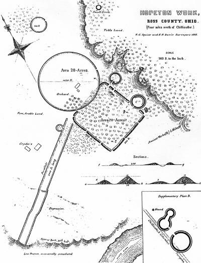
IntroductionTwo thousand years ago, American Indians of the Hopewell culture gathered in the Scioto River and Paint Creek valleys to build enormous geometic earthworks. For the next half millennia, the Hopewell culture flourished in the area creating spectacular earthen architecture and finely crafted objects. The Hopeton Earthworks complex includes a 7.3 hectare circle, a 7.86 hectare square, at least two small circles and parallel walls. Ceremonial GatheringsThe Hopeton Earthworks complex was constructed on a grand scale. The walls of the square were 3.7 meters high and 15.2 meters wide. The Great Circle’s diameter was 320 meters, with walls 1.5 meters high. The parallel walls ran for at least 730 meters and were 45.7 meters apart from each other. The construction of the earthworks was purposeful. For instance, the parallel walls were constructed to align with the sunset on the winter solstice. In addition, the American Indians that built the walls of the enclosure carefully selected the type of soil they used. Red clay soil was used on the exterior of the walls and yellow clay soil was used on the interior walls. Even more remarkable, the Great Circle’s diameter of 320 meters was repeated at four other earthworks sites: Circleville, High Bank, Newark, and Seal. 
Squier and Davis 1848 Grand & Purposeful ConstructionHopeton Earthworks was one of the first places in North America where the principles of scientific archeology were applied, and National Park Service archeologists continue this research today. A carefully measured map was first published in 1809. In 2012, archeologist used laser technology (LiDAR) to produce an elevation map of the earthwork surface accurate to +/-3 inches. Archeologist recently used global positioning systems (GPS) to map the precise location of almost 14,000 individual artifacts. This mapping effort also provided distribution information showing Hopewell artifacts widely scattered outside the earthworks, with very few inside the enclosures. This is further evidence that these spaces were set aside for sacred purposes. Most recently, an international team used state-of-the-art magnetic survey methods to detect buried archeological features across the entire Hopeton landscape. One remarkable discovery was that a row of monumental wooden posts spaced at 6 meter intervals once marked the outline of the Great Circle, forming a gigantic “Woodhenge.” Slow DemiseUnfortunately, this fabulous earthwork complex fell victim to the same fate that claimed nearly all of the many renowned earthwork complexes of southern Ohio. Two centuries of plowing gradually leveled the sloping earthen embankment walls leaving them barely visible today. The famous team of pioneering archeologists Ephraim Squier and Edwin Davis surveyed and mapped this site in 1846. Even then they noted that the Great Circle “ has been much reduced of late years by the plough.” With the advent of mechanized agriculture in the 20th century, the rate of erosion increased rapidly. This site was also threatened by the gravel quarry that can be seen to the west. Fortunately, Congress authorized the National Park Service to acquire the Hopeton site in 1980 and provided funds for its purchase in 1988. 
NPS Photos / Tom Engberg Respecting a Shared National HeritageArcheological Resources are nonrenewable and irreplaceable. In the 19th and 20th centuries, archeological sites suffered greatly from looting and damaging excavation methods. It was also common practice to excavate burial sites and place artifacts and human remains on display, with little regard for American Indian beliefs. Over time, archeological methods and respect for indigenous cultures have evolved, moving towards a greater emphasis on preservation and cultural understanding. Today, archeological investigations are conducted in consultation with Indian tribes and focus on non-burial areas in an effort to gain a more complete understanding of the Hopewell culture. Laws now protect archeological sites from unauthorized ground disturbances or artifact collecting on public properties, such as park lands. As a unit of the National Park Service, Hopeton Earthworks has been placed in the public trust so that this generation and future generations can appreciate this priceless national treasure. Visiting the SiteHopeton Earthworks was officially reopened to the public on August 25th, 2016. It is now accessible for visitors during daylight hours. There are no restroom facilities at the site. From the parking lot, Hopeton Earthworks has a 1.1 mile trail (round trip) that leads to an overlook area for viewing the earthwork remnants. See trail map below for layout of trail and parking lot access. The parking area at the trailhead is located on Hopetown road, about 1/3 mile west of North Bridge Street (S.R. 159). Scroll down this page for a detailed driving map to get to Hopeton Earthworks. Site Map & Trail Map
NPS / Tom Engberg Earthwork outline in map: United States of America (2022). “Hopewell Ceremonial Earthworks, Ohio, United States of America. Nomination to the World Heritage List by the United States of America." Hopewell Ceremonial Earthworks - Documents - UNESCO World Heritage Centre. Area Road Map
NPS / Tom Engberg |
Last updated: July 10, 2024
