Descriptions of the physiographic provinces of the United States, including maps, educational material, and listings of Parks for each.
-
Article 1: Appalachian Plateaus Province
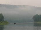
Stretching from New York to Alabama, the Appalachian Plateaus show evidence of deformation by plate collision. The birth of the mountain ranges in this region, some 480 million years ago, marks the first of several mountain building plate collisions that culminated in the construction of the supercontinent Pangea with the Appalachians near the center. Read more
-
Article 2: Basin and Range Province
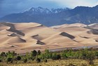
The Basin and Range province has a distinct topography characterized by alternating steep elongate mountain ranges and flat, dry deserts. This pattern extends from eastern California to central Utah, and from southern Idaho into the state of Sonora in Mexico. The combination of the arid climate and the tensional stress applied to the crust over the past 30 million years formed the horst and graben topography found in this province today. Read more
-
Article 3: Blue Ridge Province

The Blue Ridge province stretches over 550 miles from southern Pennsylvania to northeastern Georgia. The province is made up of ridges, rolling hills, and mountains of the Appalachian Mountain Belt. Within the province is the highest peak east of the Mississippi River (Mt. Mitchel at 6,684 feet), as well as 50 other peaks over 6,000 feet. Read more
-
Article 4: Cascade-Sierra Mountains Province

These two mountain ranges formed by different geological forces and processes. The Sierra Nevada mountains can be thought of as an enormous tilted fault block with a long slope westward to California's Central Valley and steep eastern slope. The Cascades form an arc-shaped band extending from British Columbia to Northern California with 13 major volcanic centers that lie in sequence. Read more
-
Article 5: Central Lowland Province

This province is the largest, covering about 585,000 miles and extending from western New York to North Dakota, and south to Texas. The province is part of the Interior Plains division of the United States and is characterized by flat lands at less than 2,000 feet above sea level; the geomorphic remnant of continental glaciation. Read more
-
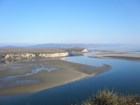
Article 6: Coastal Plain Province

The Coastal Plain Province, the flattest province, stretches over 2,200 miles from Cape Cod to the Mexican border. The plain slopes gently seaward from the inland highlands in a series of terraces. This gentle slope continues far into the Atlantic and Gulf of Mexico, forming the continental shelf. Read more
-
Article 7: Colorado Plateaus Province
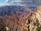
Encompassing 130,000 square miles, the Colorado Plateau straddles the region known as the Four Corners, where the states of Arizona, Utah, Colorado, and New Mexico meet. Ancient volcanic mountains, plateaus and buttes, deeply carved canyons, and amazing ranges in color are the region's defining characteristics. Read more
-
Article 8: Columbia Plateau Province

The Columbia Plateau province is enveloped by one of the world's largest accumulations of lava. The topography here is dominated by geologically young lava flows that inundated the countryside with amazing speed, all within the last 17 million years. Read more
-
Article 9: Great Plains Province
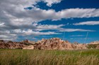
Covering over 450,000 square miles, the Great Plains province is the second largest physiographic province. The vast majority of the province is plateau-like with flat plains and little relief throughout. Though this region is known for it's flatness, some isolated mountains and lowlands are included in portions on the province. Read more
-
Article 10: Interior Low Plateaus Province

The Interior Low Plateaus is part of the Interior Plains and the elevation of the province ranges from 1,000 feet to as low as 500-600 feet. A prominant structural feature of this province is the northeast-southwest anticline that runs through the entire province. The Cincinnati Arch is the axis of the fold and is a structural high for the region. Read more
-
Article 11: New England Province
The New England province is part of the Appalachian Highlands and contains similar rock types to those found in the Piedmont. However, the provinces differ in that the New England province contains more mountains and has been subjected to Pleistocene glaciation. Structural features on this province include block-fault basins, large intrusive igneous masses, and shoreline cliffs. Read more
-
Article 12: Ouachita and Ozark Plateaus Provinces

The Ozark Plateaus and the Ouachita are actually two physiographic provinces, related spatially and compositionally. Both regions are composed of Paleozoic sedimentary rocks. To the north, the Ozark Plateaus are formed by an asymmetrical low dome, steep on the eastern slope and shallow on the west. The rocks of the Ouachita province have been deformed and eroded to form a series of east-west trending ridges and valleys. Read more
-
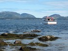
Article 13: Pacific Border Province
The Pacific Border straddles the boundaries between several of Earth's moving plates on the western margin of North America. This region is one of the most geologically young and tectonically active in North America. The generally rugged, mountainous landscape of this province provides evidence of ongoing mountain-building. Read more
-
Article 14: Piedmont Province

The Piedmont province extends from Alabama to the Hudson River in New York. At its widest the province is just 125 miles wide and contains the fewest mountains of the Appalachian Highlands. The Piedmont is often considered a rolling upland with a few monadnocks, or inselbergs, that stand out from the surface. Read more
-
Article 15: Rocky Mountain System Provinces

The Rockies form an impressive mountain barrier that stretches from Canada through central New Mexico. A look at the topography reveals a discontinuous series of mountain ranges with distinct geological origins that occurred from 170 to 40 million years ago. Read more
-
Article 16: Superior Upland Province

The Superior Upland Province is the southern extension of the Laurentian Upland Province, part of the nucleus of North America called the Canadian Shield. The rocks of the Superior Upland are mostly Precambrian metamorphic rocks and overlying Paleozoic rocks (Cambrian) covered by a thin veneer of glacial deposits left behind when glaciers melted at the end of the Pleistocene Ice Age. Read more
-
Article 17: Valley and Ridge Province

The Valley and Ridge province is a set of northeast-southwest trending valleys and ridges that stretch from central Alabama to New York. These ridges and valleys are the result of folded Paleozoic sedimentary beds that were eventually eroded away. Read more
Tags:
physiographic provinces
adirondack
appalachian plateaus
basin and range
blue ridge
cascade-sierra
central lowland
coastal plain
colorado plateau
columbia plateau
great plains
interior low plateaus
lower california
rocky mountains
new england
ouachita
interior highlands
ozark plateaus
pacific border
piedmont
st. lawrence valley
superior upland
valley and ridge
wyoming basin
mountains