
NPS photo
The Appalachian Plateaus form the northwestern-most province of the Appalachian Mountains, stretching from New York southwest to Alabama. They are composed of sedimentary rocks including sandstones, conglomerates, and shales deposited during the late Paleozoic. These rocks exist largely as horizontal beds that have been cut by streams to form the mountainous terrain that is distinctive today. Mountain ranges existing in the Appalachian Plateaus include the Catskill, Pocono, Allegheny, and Cumberland Mountains.
In addition to these sedimentary rocks, beds of coal are locally significant throughout the Appalachian Plateaus, making this area the heart of the American coal industry. Much of this mining has been done underground in the past, but new technology allows entire areas of surface to be removed, exposing the coal beneath. The first oil well in America was drilled in Bradford, Pennsylvania and extraction of high-quality oil and natural gas continues in the Appalachian Plateaus, although the quantity is dwarfed by the amounts produced in Texas and Louisiana (in the coastal plains province).
The Appalachian Mountains as a whole have a long geologic history. In the early Paleozoic, the North American craton (what would eventually become North America) was located near the equator, and the eastern margin was often submerged beneath a shallow sea depositing carbonate and other sedimentary rocks. In the mid-Paleozoic, the supercontinent Pangea began to assemble as the oceanic Iapetus plate slid underneath the eastern edge of the thick North American craton pulling with it islands, and eventually the continent Gondwana (Africa), to collide with North America. This folded and lifted the sedimentary rocks, creating the beginning of the Appalachian Mountains. As the mountains rose, streams cut through them eroding and carrying sediments to be deposited in the neighboring lowlands. These sediments became the rocks that make up the Appalachian Plateaus. Throughout the Mesozoic, as the supercontinent Pangea broke up and drifted apart, the Appalachian Mountains (then at a height similar to today’s Himalayas) slowly eroded.
The final step in building the Appalachian Plateaus as we know them occurred with uplift in the Cenozoic. This reinvigorated the streams which cut through the sedimentary rocks to create the mountainous topography we see today. Some of these incisions are truly dramatic, including the New River Gorge slicing up to 335 m (1,100 ft) through the Pottsville sandstone in West Virginia.
In the recent geologic past, the northern portion of the Appalachian Plateaus has been subject to the effects of glaciation, resulting in some distinctive landforms. Most notable of these is the Finger Lakes in New York. Their long, slender shape is the result of pre-glacial valleys that were blocked by glacial debris and filled in with water. The largest of these are Lakes Seneca and Cayuga.
Educational Resources

NPS photo
Water Cycle Unit
- Big South Fork offers a variety of free, ranger-led, curriculum-based programs that are correlated to Tennessee and Kentucky state learning standards. Our education programs are crafted for particular grade levels and their specific state standards.
Adventure Guide for Teens
- This Adventure Guide can be used on the Delaware Water Gap section of the Appalachian Trail. Simply open and print the guide to take with you when you visit this area to become a Jr. Ranger of the Appalachian Trail!
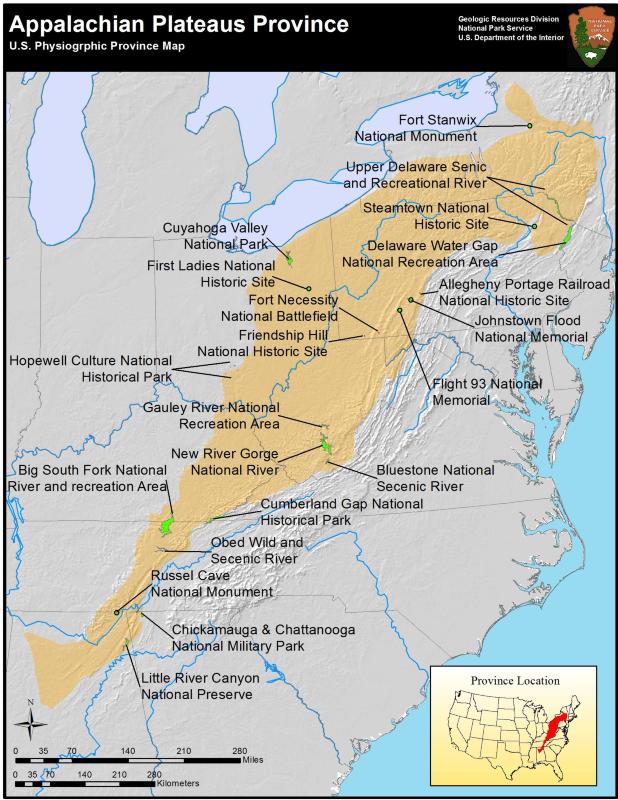
Appalachian Plateaus Parks
- Allegheny Portage Railroad National Historic Site, Pennsylvania—[Geodiversity Atlas] [Park Home]
- Big South Fork National River and Recreation Area, Kentucky & Tennessee—[Geodiversity Atlas] [Park Home]
- Bluestone National Scenic River, West Virginia—[Geodiversity Atlas] [Park Home]
- Chickamauga & Chattanooga National Military Park, Georgia & Tennessee—[Geodiversity Atlas] [Park Home]
- Cumberland Gap National Historical Park, Kentucky, Tennessee & Virginia—[Geodiversity Atlas] [Park Home]
- Cuyahoga Valley National Park, Ohio—[Geodiversity Atlas] [Park Home]
- Delaware Water Gap National Recreation Area, New Jersey & Pennsylvania—[Geodiversity Atlas] [Park Home]
- First Ladies National Historic Site, Ohio—[Geodiversity Atlas] [Park Home]
- Flight 93 National Memorial, Pennsylvania—[Geodiversity Atlas] [Park Home]
- Fort Necessity National Battlefield, Pennsylvania—[Geodiversity Atlas] [Park Home]
- Fort Stanwix National Monument, New York—[Geodiversity Atlas] [Park Home]
- Friendship Hill National Historic Site, Pennsylvania—[Geodiversity Atlas] [Park Home]
- Gauley River National Recreation Area, West Virginia—[Geodiversity Atlas] [Park Home]
- Hopewell Culture National Historical Park, Ohio—[Geodiversity Atlas] [Park Home]
- Johnstown Flood National Memorial, Pennsylvania—[Geodiversity Atlas] [Park Home]
- Little River Canyon National Preserve, Alabama—[Geodiversity Atlas] [Park Home]
- New River Gorge National River, West Virginia—[Geodiversity Atlas] ]Park Home]
- Obed Wild and Scenic River, Tennessee—[Geodiversity Atlas] [Park Home]
- Russell Cave National Monument, Alabama—[Geodiversity Atlas] [Park Home]
- Steamtown National Historic Site, Pennsylvania—[Geodiversity Atlas] [Park Home]
- Upper Delaware Scenic and Recreational River, New York & Pennsylvania—[Geodiversity Atlas] [Park Home]
Part of a series of articles titled Physiographic Provinces.
Next: Basin and Range Province
Last updated: December 10, 2024