
NPS photo
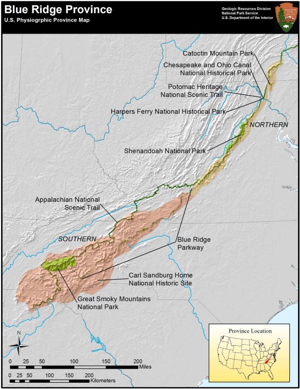
The Blue Ridge province is a mountainous belt stretching from Pennsylvania southwest to Georgia. The mountains are made of highly deformed metamorphic rocks of largely Precambrian ages. These include schists, gneisses, slates, and quartzites, and are extensively intruded by igneous bodies. To the west, the Blue Ridge province is structurally divided from the Valley and Ridge province by thrust faults that overlay in part the younger sedimentary rocks of the Valley and Ridge. In the north, the Blue Ridge is as narrow as 20 km (13 mi), but increases in width and relief to the south reaching 113 km (70 mi) and peaks above 1,800 m (6,000 ft). The Blue Ridge province includes several mountain ranges, including the Blue Ridge Range which is a drainage divide between the Great Valley to the west and the Atlantic Ocean to the east, the Great Smoky Mountains along the Tennessee-North Carolina border, the Unaka and Cahutta Mountains, and the Black Mountains which include the highest peak in the eastern United States: Mt Mitchell at 2037 m (6684 ft).
The province is home to several national parks. Shenandoah National Park covers 482 square kilometers (300 mi) and is 40% designated wilderness area. The park is traversed by the Skyline Drive, which follows the crest of the mountain and offers scenic overlooks. Skyline Drive is continued to the south by the Blue Ridge Parkway to Great Smoky Mountain National Park. Great Smoky Mountain National Park covers more than a half million acres and is one of the most visited parks. The park contains the most massive mountains in the eastern US, with many peaks rising more than 1,829 m (6000 ft) above sea level. The Great Smoky Mountains include geologically unique coves of flat, limestone-floored valleys. Due to the thrusting of metamorphic rocks, many of these coves are floored by younger rocks than the mountains that rise around them! The Catoctin Mountains are an outlying eastern prong of the Blue Ridge province and consist of monadnocks, or isolated peaks of erosion-resistant material rising from an otherwise level surface. In this case the monadnocks are gneisses and schists. This area is historically significant as a presidential retreat. Franklin D. Roosevelt named it Shangri-La, and Dwight Eisenhower renamed it Camp David after his grandson.
The Blue Ridge province is also a source of mineral resources. Feldspar is used in production of china, porcelain, and glass, and the Spruce Pine district of North Carolina is one of the country’s leading producers. Feldspar is mined from igneous intrusions made of pegmatite and an unusual feldspar-rich rock called alaskite. Micas are also abundant in these rocks, but due to economic reasons, are seldom mined. The Ducktown Basin in southeastern Tennessee was the site of one of the largest known copper deposits in the US, but acid rain produced by poor mining practices led to destruction of vegetation and runaway erosion. More recently sulphuric gasses have been collected, instead of allowed to escape to the atmosphere, and vegetation is returning to the area.
Educational Resources
Driving Through Time: The Digital Blue Ridge Parkway
- This digital drive through the Blue Ridge Parkway is available for those who would like to explore the history of this spectacular scenic drive on line. Educational materials for classroom use are part of the site
Adventure Guide For Teens
- This Adventure Guide can be used on the Blue Ridge Parkway section of the Appalachian Trail. Simply open and print the guide to take with you when you visit this area to become a Jr. Ranger of the Appalachian Trail!

NPS photo
Blue Ridge Parks
- Appalachian National Scenic Trail, CT, GA, MA, MD, ME, NC, NH, NJ, NY, PA, TN, VA, VT, WV—[Geodiversity Atlas] [Park Home]
- Blue Ridge Parkway, North Carolina & Virginia—[Geodiversity Atlas] [Park Home]
- Carl Sandburg Home National Historic Site, North Carolina—[Geodiversity Atlas] [Park Homea]
- Catoctin Mountain Park, Maryland—[Geodiversity Atlas] [Park Home]
- Chesapeake & Ohio Canal, Maryland, Washington D.C., West Virginia—[Geodiversity Atlas] [Park Home]
- Great Smoky Mountains National Park, Tennessee & North Carolina—[Geodiversity Atlas] [Park Home]
- Potomac Heritage National Scenic Trail, Washington D.C., Maryland, Pennsylvania, Virginia—[Geodiversity Atlas] [Park Home]
- Shenandoah National Park, Virginia—[Geodiversity Atlas] [Park Home]
Part of a series of articles titled Physiographic Provinces.
Previous: Basin and Range Province
Last updated: April 30, 2018