
NPS photo/James Hicks
The aptly named Valley and Ridge province, in the Appalachian Mountain region, is a series of northeast-southwest trending synclines and anticlines composed of Early Paleozoic sedimentary rocks. Limestones and shales are more susceptible to erosion and make up much of the valleys, whereas more resistant sandstones and conglomerates form the ridges. This folded strata is the result of the compression associated with the assembly of the supercontinent Pangea and the various mountain building events that produced the Appalachian Mountains. Many of these folds are plunging, meaning that the axes (fold creases) are not horizontal but are tilted to the northeast or southwest. At the southernmost extent, the Valley and Ridge appears to plunge beneath the Coastal Plain province. Erosion of this folded and tilted terrain has produced a trellis drainage pattern.
The area is home to many valuable resources, of both an economic and geoheritage sense. Vast beds of anthracite coal exist in Pennsylvania and are mined at depths up to 600 m (2,000 ft). This coal is believed to have once been continuous with the bituminous coal in the Appalachian Plateaus, but the folding and subsequent erosion that defines this province separated the beds, and the associated pressure altered the bituminous coal to anthracite. Iron and Zinc are also produced in the Valley and Ridge province, mined from the minerals hematite (iron) and sphalerite (zinc). The presence of iron, coal, and limestone in Birmingham, Alabama makes steel production an important part of their industry. Thousands of tons of marble and slate have been quarried in Pennsylvania for use in building materials. Salt springs in Virginia were an important resource for wagon trains heading west in the pioneer days. Before this, animals would gather around the springs leading to an accumulation of skeletal remains. The areas around the springs have long been important grounds for fossil collectors, one of the earliest being Thomas Jefferson!
The Great Valley is a continuous basin spanning the eastern side of the Valley and Ridge province. The Great Valley is known by different names in different states, and includes the Lebanon Valley (Pennsylvania), the Shenandoah Valley (Virginia), the Hagerstown Valley (Maryland), and the Great Valley of East Tennessee. Some of the most scenic features of the Valley and Ridge province occur where rivers and streams cut through ridges to form narrow water gaps. Most notable of these include the Delaware and Susquehanna Rivers which are flanked in places by cliffs reaching 300 m (1,000 ft).
Karst processes in the limestone beds have produced beautiful caves, well decorated with stalagmites and stalactites. These include the Skyline, Luray, Endless, and Shenandoah Caverns. Skyline Caverns include unique white calcite growths called anthodites, after the Greek work for flowers. Natural Bridge, northeast of Roanoke, Virginia is large enough to support a major highway, spanning 30 m (90 ft) and rising 65 m (215 ft) above the Cedar Creek.
")
NPS photo
Educational Resources
Adventure Guide for Teens
- This Adventure Guide can be used on the Harpers Ferry section of the Appalachian Trail. Simply open and print the guide to take with you when you visit this area to become a Jr. Ranger of the Appalachian Trail!
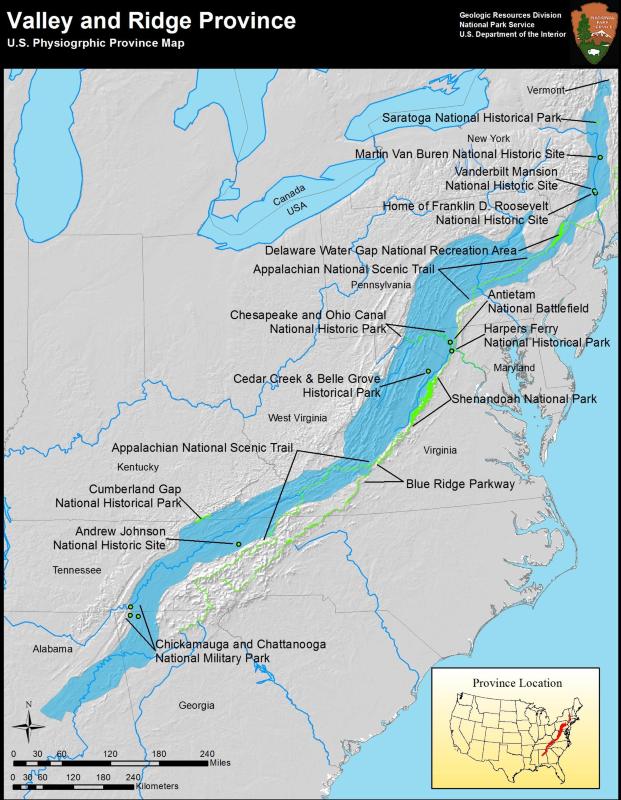
Valley and Ridge Parks
- Andrew Johnson National Historic Site, Tennessee [Geodiversity Atlas] [Park Home]
- Antietam National Battlefield, Maryland [Geodiversity Atlas] [Park Home]
- Appalachian National Scenic Trail, CT, GA, MA, MD, ME, NC, NH, NJ, NY, PA, TN, VA, VT, WV [Geodiversity Atlas] [Park Home]
- Blue Ridge Parkway, North Carolina & Virginia [Geodiversity Atlas] [Park Home]
- Cedar Creek & Belle Grove National Historical Park, Virginia [Geodiversity Atlas] [Park Home]
- Chesapeake & Ohio Canal National Historical Park, Washington D.C., Maryland, West Virginia [Geodiversity Atlas] [Park Home]
- Chickamauga & Chattanooga National Military Park, Georgia, Tennessee [Geodiversity Atlas] [Park Home]
- Cumberland Gap National Historical Park, Kentucky, Tennessee, Virginia [Geodiversity Atlas] [Park Home]
- Delaware Water Gap National Recreation Area, New Jersey, Pennsylvania [Geodiversity Atlas] [Park Home]
- Eleanor Roosevelt National Historic Site, New York [Geodiversity Atlas] [Park Home]
- Harpers Ferry National Historical Park, West Virginia [Geodiversity Atlas] [Park Home]
- Home of Franklin D. Roosevelt National Historic Site, New York [Geodiversity Atlas] [Park Home]
- Martin Van Buren National Historic Site, New York [Geodiversity Atlas] [Park Home]
- Potomac Heritage National Scenic Trail, Washington D.C., Maryland, Pennsylvania, Virginia [Geodiversity Atlas] [Park Home]
- Saratoga National Historical Park, New York [Geodiversity Atlas] [Park Home]
- Shenandoah National Park, Virginia [Geodiversity Atlas] [Park Home]
- Vanderbilt Mansion National Historic Site, New York [Geodiversity Atlas] [Park Home]
Part of a series of articles titled Physiographic Provinces.
Previous: Superior Upland Province
Last updated: May 1, 2018