
NPS / Neal Herbert Visit the Albright Visitor CenterTalk to a ranger at the Albright Visitor Center (originally quarters for single Army officers) and learn more about the history and wildlife of Yellowstone. Get help planning your day and stamp your passport. Kids can become Junior Rangers. 
NPS / Neal Herbert Tour Historic Fort YellowstoneYellowstone's first superintendents struggled with poaching, vandalism, squatting and other problems. In 1886, US Army soldiers marched into Mammoth Hot Springs at the request of the Secretary of the Interior and took charge of Yellowstone. Soldiers oversaw Fort Yellowstone's construction—sturdy red-roofed buildings still in use today as the Albright Visitor Center, offices, and employee housing. 
NPS / Neal Herbert Explore the Mammoth Hot Springs TerracesWalk on boardwalks above the steaming hydrothermal features or take a drive around the vibrant travertine terraces. In the winter, ski or snowshoe among the whiffs of sulfur along the Upper Terraces. Go HikingMany trails into Yellowstone's wilderness begin in the Mammoth Hot Springs area. Plan a short day or extended hike with our day hiking guide, which feature hikes selected by park rangers. Always carry rain gear, extra food and water, and other emergency equipment when venturing into the backcountry. Be sure to obtain current trail condition and bear activity information at the Albright Visitor Center. Bunsen Peak may be climbed via a trail that starts at the Golden Gate. Another trail, the old Bunsen Peak road, skirts around the flank of the peak from the Youth Conservation Corps camp to the Golden Gate. This old road may be used by hikers, mountain-bikers, and skiers in winter. 
NPS Research Yellowstone's HistoryThe Heritage and Research Center in Gardiner, Montana is a state-of-the-art facility that is home to Yellowstone's museum collection, archives, research library, and archeology lab. Visit the small rotating exhibit in the lobby or plan ahead and take a behind-the-scenes guided tour. Tours are generally available twice a week from June to September; reservations are strongly recommended. Stay Here (or Close By)There is one hotel, the Mammoth Hot Springs Hotel and Cabins, in this region, as well as two campgrounds, the year-round Mammoth Campground and the seasonal Indian Creek Campground. Additional lodging options can be found in the nearby town of Gardiner, Montana at the north entrance to the park. 
Camp in a Campground
Plan a night in one of twelve park campgrounds. 
Stay in a Lodge
Pick a lodge that's right for you and make a reservation early! Find Evidence of GlaciersThe Mammoth area exhibits much evidence of glacial activity from the Pinedale Glaciation. The summit of Terrace Mountain is covered with glacial till, thereby dating the travertine formation there to earlier than the end of the Pinedale Glaciation. Several thermal kames, including Capitol Hill and Dude Hill, are major features of the developed areas of Mammoth Hot Springs. Ice-marginal stream beds are in evidence in the small, narrow valleys where Floating Island Lake and Phantom Lake are found. In Gardner Canyon, one can see the old, sorted gravel bed of the Gardner River covered by unsorted glacial till. 
NPS/Jacob Frank Make a Historic Entrance at Roosevelt ArchThe first major entrance for Yellowstone was at the north boundary. Before 1903, trains would bring visitors to Cinnabar, Montana, which was a few miles northwest of Gardiner, Montana, and people would climb onto horse-drawn coaches there to enter the park. In 1903, the railway finally came to Gardiner, and people entered through an enormous stone archway. Robert Reamer, a famous architect in Yellowstone, designed the immense stone arch for coaches to travel through on their way into the park. At the time of the arch's construction, President Theodore Roosevelt was visiting the park. He consequently placed the cornerstone for the arch, which then took his name. The top of the Roosevelt Arch is inscribed with "For the benefit and enjoyment of the people," which also appears in the National Park Service Organic Act of 1916. 
NPS / Neal Herbert Watch for WildlifeElk, bison, pronghorn, and mule deer frequent the grasslands around the north entrance of the park, depending on the season. The North Entrance Road up to Mammoth Hot Springs runs along the Gardner River. The road winds up the Gardner River canyon, past crumbling walls of sandstone and ancient mudflows. The vegetation is much thicker in the canyon than on the open prairie down below, the common trees being Rocky Mountain juniper, cottonwood, and Douglas-fir. Low-growing willows also crowd the river's edge in the flatter, flood-prone sections of the canyon. Watch for wildlife, which varies by the season. Eagles, osprey, dippers, and kingfishers can be spotted along the river, while bighorn sheep climb along the steeper parts of the canyon. Elk are common in Mammoth Hot Springs, while bison can often been seen along the road out to Tower–Roosevelt. Observe Cascading WaterThree waterfalls are easy to visit in this region. Heading east from Mammoth Hot Springs, you can stop by Undine Falls, a 60-foot (18.3-m) waterfall, or take a short 1/2-mile (0.8-km) hike to the long, 79-foot (24-m) cascade of Wraith Falls. Driving south of Mammoth Hot Springs through the Golden Gate will lead you right past Rustic Falls, a splendid little falls especially in the spring. 
NPS/Dave Krueger Go on a Driving TourThere are two side drives in this region. Both of them are open only during the summer season, with Blacktail Plateau Drive opening the latest due to being in a bear management area. Upper Terrace Drive is a short, one-mile (1.6-km) loop drive with a few parking areas along the way. The drive leads you to views of the Main Terraces of Mammoth Hot Springs, views of Fort Yellowstone and the Gardner River, and right up to hydrothermal features like Orange Spring Mound. Blacktail Plateau Drive is an unpaved, six-mile (9.7-km) one-way road that meanders through alpine forests and meadows. It provides a more rustic way to travel to Tower–Roosevelt, and gives opportunities to see wildlife and take in the beautiful alpine scenery. Mammoth Hot Springs Area Frequently Asked QuestionsNo, the overall activity and volume of water remains relatively constant. Sometimes the water is concentrated in a few springs; at other times, it may spread across many outlets. In every case, water follows the path of least resistance, which could be above ground or underground. Scientists estimate that, at any given time, about 10% of the water in the Mammoth Hot Springs system is on the surface; the other 90% is underground.
Limestone, a naturally white rock, underlies this area. Hot water dissolves the mineral calcium carbonate from the limestone, which is deposited at the surface to form travertine. Colors in the hot springs come from thermophiles.
In the surrounding mountains, rain and snow soak through the ground. The water is heated below the surface. As it rises, it dissolves the limestone rock that lies beneath the Mammoth area. The terraces are like living sculptures, shaped by the volume of water, the slope of the ground, and objects in the water’s path. Travertine builds up rapidly and causes features to change quickly and constantly.
Mammoth Hot Springs lies to the north of the caldera. Scientists continue to study where the heat for the hot springs comes from. One possibility is the volcano’s magma chamber, similar to the heat source for other thermal areas closer to the 631,000-year-old caldera. There may also be basaltic magma bodies, related to the Yellowstone volcano, deep underground between Norris and Mammoth, which could be a contributing heat source.
No, the travertine features are very fragile.
At 8,564 feet (2610 m), Bunsen Peak south of Mammoth Hot Springs is an intrusion of igneous material (magma) formed approximately 50 million years ago. Bunsen Peak and the “Bunsen burner” were named for physicist Robert Wilhelm Bunsen. He was involved in pioneering geyser research in Iceland. His theory on geyser activity was published in the 1800s, and is still considered accurate.
Many of the older buildings grouped together in Mammoth belong to Fort Yellowstone, built by the US Army from 1891 to 1913, when it managed the park. A self-guided trail goes through this National Historic Landmark District. Most of the buildings constructed during the Army era are still standing and used by the National Park Service as park headquarters. At present, many of these buildings are used for park administration. Others are employee residences.
The mountain is called Mount Everts, 7,841 feet (2390 m) high. It consists of layered sandstones and shales—sedimentary deposits from a shallow inland sea 70–140 million years ago. Its steep cliffs—eroded by glaciers, floods, and landslides—provide habitat for bighorn sheep. It was named for explorer Truman Everts, a member of the 1870 Washburn Expedition who became lost. He was found east of the mountain, near Blacktail Plateau.
Elk live here all year, and are wild and unpredictable. Each year visitors are chased, trapped, and sometimes injured by elk. Look for Uinta ground squirrels in front of the visitor center and among the hotel cabins during summer. You might see bighorn sheep in the canyon north of Mammoth. South of Bunsen Peak is Swan Lake Flat, where visitors often see elk, bison, and sometimes grizzlies and wolves. It is also an excellent place for watching cranes, ducks, and other birds.
Albright Visitor Center
Learn about wildlife and get park information at this visitor center located near the North Entrance. 
Historic Mammoth
Learn about Mammoth Hot Springs' historical district including the Roosevelt Arch. 
Mammoth Hot Springs Hikes
The trails around Mammoth Hot Springs have a full range of difficultly and environments to explore. 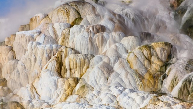
Mammoth Area Accessibility
Learn about the accessibility options in the Mammoth Hot Springs area. 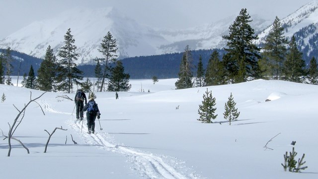
Mammoth Trails
Discover the skiing and snowshoeing opportunities around Mammoth Hot Springs. 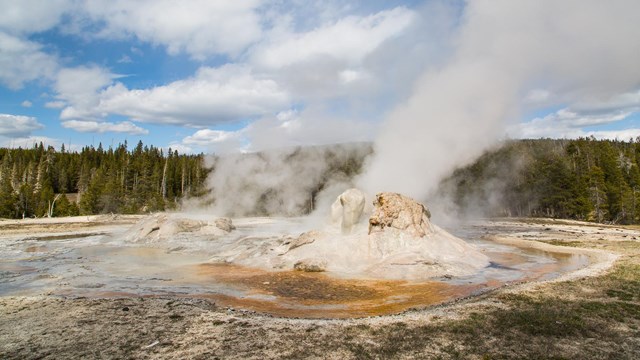
Places To Go
Discover the highlights of Yellowstone's vast 2.2 million acres, ten visitor centers, and eight developed areas. 
Plan Your Visit
Yellowstone changes with the seasons—make the most of your visit! Plan ahead to keep your trip safe, fun, and unforgettable. |
Last updated: April 30, 2025