NPS Photo. 
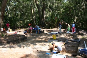
NPS Photo Santa Cruz y San Bueneventura de Guadalquini Spanish Mission A.D. 1684 – ca. A.D. 1696 Dateline: July 13, 2011; Cedar Point Area, NPS, Timucuan Ecological and Historic Preserve National Park Service, Timucuan Ecological and Historic Preserve and the University of North Florida (UNF), Department of Anthropology completed their 10th season of cooperative archaeological field schools within the Preserve. The 2011 field season included UNF students and added a new opportunity for the public to join in the archaeological research. Through the UNF Continuing Education Program members of the public were invited to aid in the excavation of a Spanish mission site at the Cedar Point area of the Park. Those involved received firsthand experience in excavation techniques, the field identification of artifacts, and mapping archaeological materials and features. The site location is where the former Spanish Mission Santa Cruz y San Bueneventura de Guadalquini once stood. A mixture of various Native American groups, including Mocama speaking people Colones, Yguajas and Asajo (Yamassee), established the mission on the southern end of Black Hammock Island in 1684. These native groups had fled their previous mission site, also called Santa Cruz, located on St. Simons Island in Georgia. The original mission site was established in 1605 and lasted until the movement south in 1684. English and French pirates and raiders drove these groups south to the area of northeast Florida for protection offered by the Spanish. A census taken in 1689 indicated there were 60 families (300 people) living at the mission at Cedar Point. A 1695 visitation found Santa Cruz housing 5 caciques (leaders) as well as 2 inihas (2nd in command), along with the head cacique who oversaw the wellbeing of all living at Santa Cruz. The inclusion of multiple leaders at the mission suggests the residents of the mission were drawn from several existing settlements. Sometime between 1695 and 1697 the population of Santa Cruz joined the mission people at San Juan del Puerto on Fort George Island, Duval County, Florida. The people of Santa Cruz were under threat of attack from nearby enemy groups and vulnerable due to their close proximity to the mainland. Prior to this move, the Santa Cruz leader had a council house built for them at San Juan. The Santa Cruz cacique later became the head cacique for the San Juan mission in 1701. In 1702 Carolina raiders lead by Colonel James Moore razed and burned both the Santa Cruz and San Juan missions en route to a siege on St. Augustine. Thus, the era of the influence of the Spanish Missions effectively ended in Northeast Florida. As mentioned above, a council house was built for the mission residents who moved to San Juan. Following previous excavations at the Santa Cruz mission site, this year’s field school and public archaeology program from UNF uncovered features related to a large structure (a possible council house) at the mission site. These features are the remnants of post holes where structural posts were placed for walls. Walls were built in between the posts from wattle and daub. When bisected, the post hole features reveal a conical appearance where a square post was placed in the hole and shell and dirt were tamped down around it to hold the post in place. This is much like what is done today for setting posts in cement. Also uncovered at the site were a significant amount of San Marcos mission related pottery, Spanish majolica, olive jar sherds, faunal remains and other accouterments of daily living. The structure appears to be very large with post holes indicating an approximately east to west bearing wall of at least 10 m (31 ft) in length by 6 m (20 ft) bearing approximately north to south. However, since the complete building has not been excavated it could be substantially larger. The only previously excavated council house in Florida is located at Mission San Luis in Tallahassee. This council house was a round structure 125 feet in diameter and housed 2000 to 3000 people at a time. If the council house at Santa Cruz is of a similar nature it would have been designed to house the 300 inhabitants known to have lived there. The large structure currently under excavation at Santa Cruz appears to be of a rectangular nature rather than round as found at San Luis. This may indicate a change in architectural style due to Spanish influence. In any case, the structure at the Santa Cruz site is likely to be substantially larger than what is now uncovered. Additional excavation of the site is needed to fully understand the history and landscape of Santa Cruz. Through artifact analysis, the research of historical documents and the recent discovery of structural features, the Park has verified the location of the Santa Cruz y San Bueneventura de Guadalquini mission at Cedar Point. Future cooperative efforts with the University of North Florida will enable the Park to better define the mission landscape, locate other areas of occupation and offer insight as to how the indigenous groups of the Southeast lived. Article presented by: Timucuan EHP, Resource Stewardship and Partnerships John C. Whitehurst, Cultural Resource Specialist Barbara P. Prettyman, Archaeological Technician 
NPS Photo. |
Last updated: July 17, 2020
