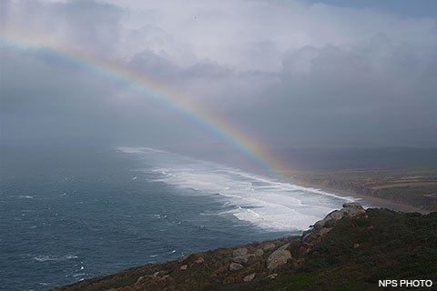
A rainbow forms over Point Reyes Beach during a winter storm.
Warm dry summers and cool rainy winters characterize the Point Reyes Peninsula's climate, similar to the type of climate that prevails on the Mediterranean. While this is the general trend, the weather can vary greatly depending on which side of the Inverness Ridge you are visiting.
There are usually moderate to strong winds on the exposed headlands and outer beaches. The strongest winds occur in November and December during occasional southerly gales. While wind speeds tend to average about 32 km/h (20 mph) at the Lighthouse on the Point, storms often bring winds with gusts of 112 km/h (70 mph), with the strongest winds measured at 213 km/h (133 mph). Winds are much lighter on the eastern side of the Inverness Ridge, but it is an unusual day that does not bring afternoon breezes to Point Reyes.
Headlands and beaches on the Pacific Coast are subject to frequent heavy fogs. During most of the year, the water temperatures near the coast are lower than that of the ocean farther to the west. As warm moist air from farther offshore travels east it encounters these frigid coastal waters. The air cools, condenses, and produces fog. The fog can blanket the ocean for more than 80 km (50 miles) off the shore and often smothers the beaches. Heavy fogs are most common in July, August and September.
Sunshine and higher temperatures can be found inland. The east side of Inverness Ridge and the beaches of Tomales Bay are sheltered, with sunny areas for picnicking and swimming. Inland temperatures in the summer are often 10°C (18°F) degrees warmer than temperatures on the Headlands and outer coast.
Rainfall averages about 30 cm (12 inches) per year out on the Point where the Lighthouse is located, with the heaviest rainfall in December, January, February, and March. A few miles inland the rainfall is much greater, averaging about 90 cm (36 inches) a year at Bear Valley. Although there is scarcely any rain from mid-April to October, the night and morning coastal fogs condense on the trees and keep the wooded hills moist.
The moderating influence of the Pacific Ocean creates a climate with no great extremes of heat or cold; average monthly temperatures differ only about 16°C (28°F) from high to low throughout the year. To get a better idea of what kind of weather to expect during your visit, go to the Weather page in the Plan Your Visit section.
From 2007 to 2012, Pacific Coast Science and Learning Center Science Communication Interns produced a series of podcasts, videos, and audio-slide shows exploring science from Bay Area national parks. One of these The Natural Laboratory multimedia products focused on the impacts of a warming climate on the area's fog. View the video or listen to the podcast below. Visit our Multimedia Presentations: The Natural Laboratory page for additional videos and podcasts.
The Natural Laboratory Podcast: Declining fog in coastal California?
A The Natural Laboratory podcast produced by the Pacific Coast Science and Learning Center in 2012 in which Cassandra Brooks interviews Mike Vasey and Todd Dawson about recent studies indicating that the fog is declining along the California coast.
Credit / Author:
Cassandra Brooks / Pacific Coast Science and Learning Center
[Introduction]
[theme music]
This is the Natural Laboratory, a podcast exploring science for Bay Area National Parks. I'm Cassandra Brooks.
[theme music fades out]
[Interview with Mike Vasey]
Cassandra Brooks: Can you tell me where we are right now?
Mike Vasey: Point Reyes Peninsula, which is really one of the...one of the fog capitals of the universe. And looking out over, uh, Point Reyes Headland, and Drakes Bay, and the Pacific Ocean, and it's a fantastic scene. Along the coast it's particularly exciting; you have so many different unique species that occur.
CB: That's Mike Vasey, a lecturer at San Francisco State University and PhD student at UC Santa Cruz who studies plants on the California coast. The rich, lush environment of Point Reyes—and really all of coastal California—heavily depends on the fog. During rainless summers, this fog—which can account for 1/3 of the ecosystem's water input—is critical to the persistence of the local plants and ecosystem.
CB: Earlier you were explaining to me where fog originates from. Can you tell that story to me now?
MV: Let me, uh, start here on the coast. We have upwelling of really cold waters—very rich, nutrient rich—right off the...right off the immediate coast. And then, winds that are warmer, that have a lot of moisture, come sweeping in off the Pacific, and when they hit that upwelling cold water, they condense into fog. Then the third big factor is that you have these, uh, hot air masses that are moving out towards the ocean at high elevation. And as they move out towards the Pacific, they kind of depress down and cause an inversion of that condensation—that cloud layer—so it becomes this so-called marine layer. And this occurs late spring through the summer.
[Interview with Todd Dawson]
CB: But recent studies have indicated that the fog is declining from the California coast. I went to meet with Todd Dawson, a professor at UC Berkeley who has studied California fog for decades. In a recent study with former graduate student and postdoc Jim Johnstone, Dawson found some troubling trends.
Todd Dawson: And Jim and I basically discovered that, if we looked over the last 50 to 60 years, we started to see that, not only temperatures along the coast were warming up, but fog was actually declining. And when we started to really look at that even over longer time frames, we began to see, really, over the last century, fog has been declining, and it's declined by about 30 percent in about 100 years here in coastal California.
CB: Are you able to see any impact on the environment yet from this? Or will it take longer to see a shift?
TD: We're beginning to see some signs of that...that change in the fog-water inputs maybe having some impacts in the southern parts of, say, the redwood range. So, you go down to southern Big Sur, right at the very southern end of where the coast redwood lives, and we begin to see, now, that the summers are a lot drier, soils dry out, they're drier for a longer period of time.
CB: And it means that, perhaps, the redwood range will shift north, or will just decrease, or might go away all together?
TD: Yeah. Some of the predictions that have been, um, sort of, recently released, and this work has been done by a woman named Healy Hamilton, that's really been interested in, sort of, modeling climatic envelopes of plants. And she's focused very specifically on the coast redwood. And she said just what you've said, is that the climatic envelope that's gonna favor the coast redwood is gonna creep its way north into Oregon and, also, it's gonna creep its way west. And, of course, that's impossible because as we go west, we hit the Pacific Ocean. So, what that really means is that the envelope is getting narrower, it's moving north. And, at the southern end of the range, it's gonna get drier and hotter and we're probably gonna be losing trees there, eventually. Whether that happens in the next 20 years or the next 50 years, we can't really say yet.
CB: What can people do, you know? What can the national parks do, or the state parks do to deal with that?
TD: Well, ther...I think there's a couple of strategies that we've been talking with the parks, um, about. Um, of course, there's always playing a very active role. I mean, you know, we can plant trees, and we can plant trees into areas that may be much more favorable—little microclimatic areas—little niches that we know could be very favorable to healthy redwood growth. Um, those are, obviously, gonna be wetter, cooler areas 'cause the redwoods really love those. We could also try to—in a...in a, sort of, entire geographical context—go and do an analysis of where are those climatic niches that might be very favorable for future recruitment and healthy growth for mature trees, and make sure those areas are set aside.
CB: A few of my friends I mentioned to that, you know, I was doing this story on how fog is declining in the...in the Bay Area and Santa Cruz area, they said, “No way! It has not. You know, I see just as much fog. There's more fog!”
TD: You have to take, kind of, the normal oscillation, along with the long-term trends, to really, kind of, understand how something like fog decline or temperature increases really play out. In our human experience, you know, we kind of remember one year at a time. And I think, sometimes, that's why people say, “Hey, wait a minute. It was a really foggy year last year!” And you go, “You know, you're right. It was.” But in the long-term picture, it's actually been on the decline.
[Conclusion]
[theme music]
With the Pacific Coast Science and Learning Center, I'm Cassandra Brooks.
[theme music fades out]
415-464-5100
This number will initially be answered by an automated attendant, from which one can opt to access a name directory, listen to recorded information about the park (i.e., directions to the park; visitor center hours of operation; fire danger information; wildlife updates; ranger-led programs; seasonal events; etc.), or speak with a ranger. Please note that if you are calling between 4:30 pm and 10 am, park staff may not be available to answer your call.