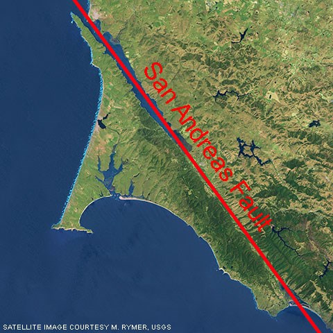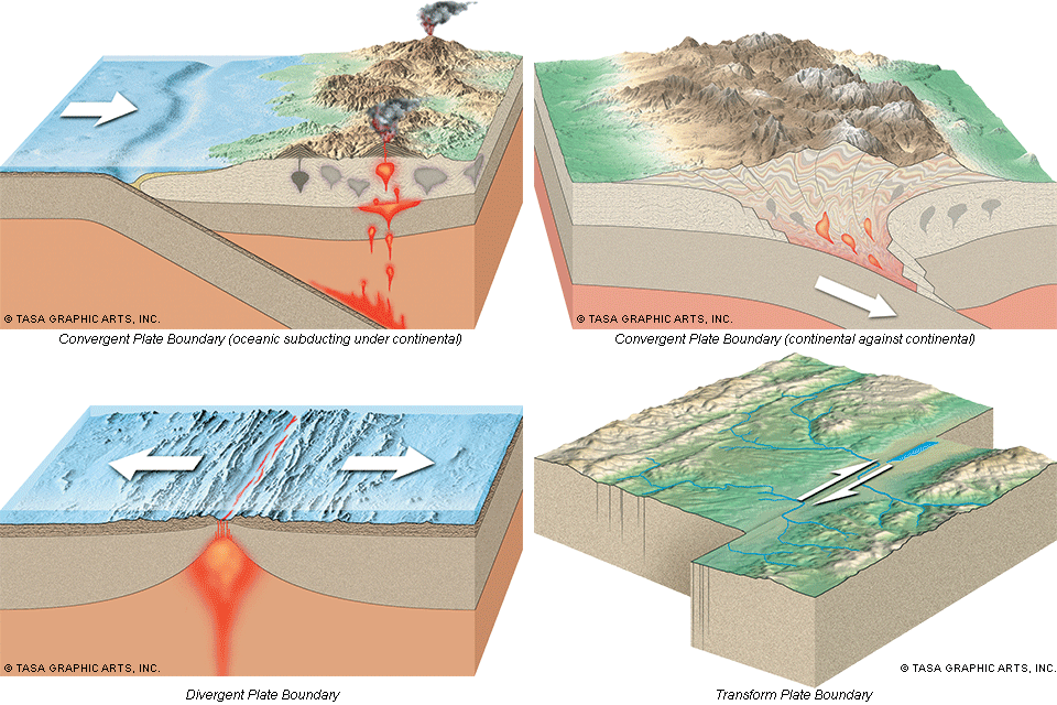
On the Boundary of ChangeBoundaries limit and divide. They mark where one thing ends and another begins. Boundaries are also places of dynamic change. Along the air/water boundary, light bends, or refracts, as it leaves one medium and enters another. Along the cell membrane, hormones initiate chemical reactions within the cell. Along geologic boundaries, landscapes are shaped. The San Andreas Fault is such a boundary, the division between two great tectonic plates: the Pacific Plate and the North American Plate. It is also the site of geologic forces that give rise to earthquakes and shape the land as we know it. Our Everchanging WorldWhile the tectonic boundary between Point Reyes and the rest of North America divides and shapes the landscape along the San Andreas Fault, tectonic activity also shapes our entire planet. Throughout the world, circulating magma energizes tectonic boundaries that mold land into mountains, volcanoes, valleys, and hills. Although tectonic boundaries may divide plates, they unite areas around the earth in a shared global geologic heritage. Types of Plate Boundaries
Monumental change occurs along plate boundaries. When oceanic and continental plates collide, oceanic plates subduct beneath (dive under) continental plates and, on the surface, mountain ranges rise and volcanoes erupt; the Sierra Nevada, Cascades, and Andean Ranges all emerged from this type of collision. On the other hand, when the impact of two continental plates compresses the crust along a plate boundary, mountain ranges without much, if any, volcanism are thrust thousands of feet high, as were the Alps and Himalayas. Diverging plate boundaries, most frequently observed now on the floor of oceans, spawn new crust as hot magma bleeds up between the plates, hardens into new seafloor, and pushes the existing seafloor away from the rift on both sides. The San Andreas Fault is not the site of plate collisions or diversions but of lateral, or transform, movement where the plates slide past one another—the Pacific Plate traveling northwest relative to the North American Plate. The San Andreas FaultPoint Reyes National Seashore lies on the eastern edge of the Pacific Plate, an oceanic plate underlying nearly the entire Pacific Ocean from the North American west coast north to Alaska, west to Japan, south to New Zealand, and east to the eastern South Pacific Ocean. East of the national seashore, the North American Plate underlies most of North America (including Greenland) and extends to the mid-Atlantic Ridge near the middle of the Atlantic Ocean. The San Andreas Fault runs the length of the boundary between the Pacific Plate and North American Plate in California. The narrow Tomales Bay and the narrow Olema Valley, along which Shoreline Highway (Highway 1) travels, overlie the San Andreas Fault and were formed as a result of tectonic forces. Not only do two plates meet along the San Andreas Fault, but they move against each other. The forces causing this movement lie more than 90 miles (150 km) below our feet in the earth's mantle. Currents of magma slowly circulate up from within the mantle, spread out under the oceanic and continental crusts, carry the plates along then sink to circulate again. Like a crowded bumper car rink, the plates crash and grind into each other as they move. It is along plate boundaries where the action takes place. The Pacific plate is estimated to creep northwestward about two inches a year, but the most dramatic displacement of this fault occurred in 1906 when the Point Reyes Peninsula leapt ~20 feet northwestward. The San Andreas Fault divides two landmasses of differing geologies. East of the fault lie rocks known as the Franciscan Complex, a combination of graywacke, shale, chert, serpentinite, and pillow basalt. Granitic rocks form the base of the National Seashore west of the fault; similar granitic rocks are found in the Tehachapi Mountains at the southern end of the Sierra Nevada. As the granitic rocks moved north to their present location, conglomerate, sandstone, shale, greensand, siltstone, and mudstone were deposited on top of the granitic rocks. The juxtaposition of these two land masses results from geologic forces along the San Andreas Fault. The Pacific and North American Plates do not always glide smoothly past each other. The movements are often erratic, jerky, and sudden. We call these movements earthquakes. Although currents of magma below each plate power the movement, friction between the rocks along the fault prevents the plates from moving. This friction causes stress to build up along the San Andreas Fault, bending and deforming the rocks as they store potential energy as in a stretched rubber band. When the rocks can no longer resist the strain, they fracture suddenly, releasing decades of accumulated energy in a few seconds. Moments like these dramatically alter landscapes. Millions of Years of MotionThe cumulative effect of countless earthquakes and gradual plate movement along the San Andreas Fault over the past 16 million years has shaped the land around it. The Point Reyes peninsula has traveled over 100 miles along the fault from near Monterey. Movement along the fault sculpts the long, parallel ridgelines that border the Olema Valley. Within this valley, plate movement molds smaller shutter ridges—small hills along the fault formed as a result of local compression and uplift—and sag ponds—basins created by the downdropping of earth as land stretches apart. These features occur elsewhere in California along the San Andreas Fault, marking its path and connecting Point Reyes to other areas in the state with a shared geologic history. A Community of FaultsThe San Andreas Fault is part of a large community of faults along the tectonic boundary, one of hundreds of faults in the Bay Area alone and among thousands of others along its length. The San Andreas Fault System, the broad collection of faults between the Pacific and North American plates, accommodates overall transform movement between them. Each fault within the system helps shape the land we see today. The fault system itself also undergoes transformation. Individual faults lock up and new ones rupture. Some scientists speculate that transform movement between the plates will abandon the San Andreas Fault Zone and concentrate along faults east of the Sierra Nevada, ripping more of California from North America. Learn MoreThe most accessible location within Point Reyes National Seashore to view the San Andreas Fault Zone is along the Earthquake Trail, located off of the dirt/gravel parking lot across from the Bear Valley Visitor Center. To learn more about the 1906 Earthquake, the San Andreas Fault, and plate tectonics, check out our 1906 Earthquake Centennial Resource Newsletter (5,501 KB PDF) and the Point Reyes National Seashore Geologic Activity webpage. Visit Plate Tectonics & Our National Parks, which includes a page about Transform Plate Boundaries. Visit the U.S. Geological Survey's Earthquake Hazards Program web pages to learn more about earthquakes, plate tectonics, and where recent earthquakes originated. The San Andreas Fault In The San Francisco Bay Area, California: A Geology Fieldtrip Guidebook To Selected Stops On Public Lands, by Philip W. Stoffer. 2005. USGS Open-File Report 2005-1127. Chapter 9: Geology at Point Reyes National Seashore and Vicinity, California: A Guide to San Andreas Fault Zone and the Point Reyes Peninsula - 28 pages. (1,532 KB PDF) PDFs of the informational signs along the Earthquake Trail.
Adobe® Acrobat Reader® may be needed to view PDF documents |
Last updated: June 26, 2025
