West Fork Dosewallips River Trail

 
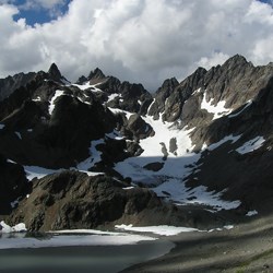
Snow covered rocky mountain against a fluffy white clouded sky.
Mount Anderson from end of Anderson Moraine Trail

NPS Jim Patterson

Description
Trail Conditions
Camping
Special Concerns
Safety
Map


Notices:

  • Dosewallips Road is washed-out 6.5 miles from the trailhead. Hikers can get around the washout using a temporary trail.
  • For the most up to date information on how to obtain a Wilderness Permit, visit our Wilderness Backpacking Reservations page.
 

Description

Ecosystem type: Montane forest, subalpine meadow
Trail tread types: Maintained
General elevation trend: Moderate
Unique features: River, glaciers, ancient forest
Level of difficulty: Moderate
Distance: 9.1 miles from Dose Forks to Anderson Pass. Road end to Anderson Pass is 16 miles.
River crossings: Most creeks have footlogs or bridges. The footbridge just above Diamond Meadow is out. Crossing of the West Fork at Honeymoon Meadows may be hazardous in spring and/or after heavy rain.
Elevation change: 1,600 feet to 4,464 feet
Best Season: Low Elevations—April through October, sometimes year-round. High Elevations—early July through October.


Camping
Food Storage Method: Some community bear wires are available along this route. For the latest status on which bear wires are still usable, visit our Wilderness Interactive Map page. Bear canisters are required in the Anderson Pass and Anderson Moraine area.
Campsites: Dose Forks, Big Timber, Diamond Meadows, Honeymoon Meadows, Lacrosse Pass Junction, Camp Siberia
Toilet Facilities: Pit toilets are located at Big Timber, Diamond Meadows, Honeymoon Meadows, and Camp Siberia. In other areas, bury human waste 6-8" deep and at least 200 feet from campsites or water. Pack out your toilet paper.
Water Source: West Fork Dosewallips River and tributary streams. There is very little water at Anderson Pass. Always boil, filter, or chemically treat your drinking water to prevent getting Giardia.
Stock: Allowed. Stock groups must camp in designated stock camps located at Big Timber and Diamond Meadows. Visit our Trail Conditions page to see the latest status on accessibility to stock.


Special Concerns

Leave No Trace: Leave No Trace of your stay to protect vegetation and prevent further camping regulations. Camp in established sites or on bare ground.
Campfires: To protect sensitive vegetation, campfires are prohibited above 3,500 feet. Where fires are permitted, leave no trace of your fire ring. Burn dead and down wood only.
Respect Wildlife: To protect bears and other wildlife, all food, garbage, and scented items must be secured from all wildlife 24 hours a day.


Trail Conditions

Trail condition reports as reported by visitors and staff.
 

Safety

  • Always carry the 10 Essentials: map, compass, flashlight, knife, matches, nylon cord, extra food and water, and rain gear with warm clothes.
  • Map & compass navigation skills may be necessary in places along this trail. Snow may cover higher reaches of this trail in any season, so know how to navigate without a trail for guidance.
  • Ice axe and self-arrest skills are necessary to hike this trail when snow covered.
  • Let someone know where and when you are taking your hike. Make emergency plans for them to follow if you do not return.
  • Watch the weather before and during your hike. Storms move quickly. Whiteouts are sudden. Always check the weather forecast prior to your hike.
 
An unpaved dirt path in a forest.
West Fork Dosewallips River Trail

NPS Jim Patterson

 
A forest of trees with sunlight pouring through and dappling the forest floor.
Diamond Meadows Camp

NPS Jim Patterson

 
A backpacker walks down a trail through a meadow heading toward a forest with mountains rising up behind the trees.
Honeymoon Meadows

NPS Jim Patterson

Last updated: September 8, 2024

Park footer

Contact Info

Mailing Address:

600 E. Park Avenue
Port Angeles, WA 98362

Phone:

360 565-3130

Contact Us