Glacial Dynamics

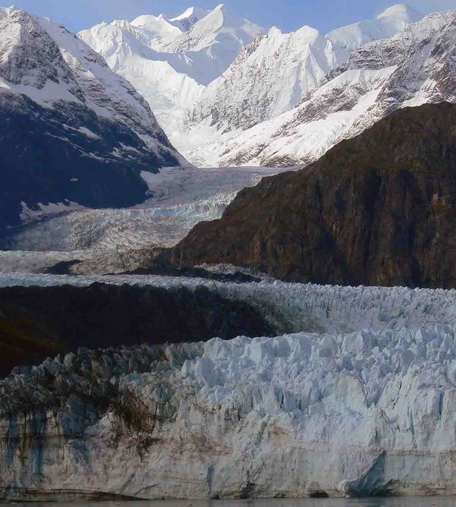
Margerie Glacier in Glacier Bay NP&Pres
Margerie Glacier in Glacier Bay National Park and Preserve is one of the park's tidewater glaciers, critical for providing habitat for seals and other species.

Sensitive to seasonal variation in temperature and precipitation, glaciers are excellent indicators of regional and global climate. More than 50 glaciers cover 48% of the Glacier Bay National Park and Preserve's terrestrial area. Glaciers continue to shape the park’s dramatic scenery, topography, and landforms while providing billions of gallons of freshwater to a pristine glacial fjord ecosystem. Even seemingly subtle changes in glacial dynamics can have far-reaching consequences, through changes in hydrology and runoff patterns, degree of ocean stratification, carbon delivery, and capacity of the system to buffer against ocean acidification.

An initial inventory of glaciers in Alaska’s parks was completed; otherwise, this vital sign is in the process of development. To learn more, check out the science exploration of the outer coast of Wrangell-St. Elias and Glacier Bay national parks and preserves.

Contact: Andrew Bliss and Michael Loso


Learn more

Showing results 1-10 of 10

    • Locations: Wrangell - St Elias National Park & Preserve
    • Offices: Central Alaska Inventory & Monitoring Network, Southeast Alaska Inventory & Monitoring Network
    A glacier in the foreground and mountain in the distance.

    Read a summary and abstract about modeling glacier retreat from the published article: Brinkerhoff, D., B. Tober, M. Daniel, V. Devaux-Chupin, M. Christofferson, J. Holt, C. Larsen, M. Fahnestock, M. G. Loso, K. Timm, R. Mitchell, and M. Truffer. 2024. The demise of the world’s largest piedmont glacier: A probabilistic forecast. The Cryosphere.

    • Locations: Klondike Gold Rush National Historical Park
    • Offices: Geologic Resources Division
    mountain pass trail

    Each park-specific page in the NPS Geodiversity Atlas provides basic information on the significant geologic features and processes occurring in the park.

    • Locations: Glacier Bay National Park & Preserve
    • Offices: Geologic Resources Division
    ice floating on inlet with tidewater glacier in distance

    Each park-specific page in the NPS Geodiversity Atlas provides basic information on the significant geologic features and processes occurring in the park.

    • Locations: Glacier Bay National Park & Preserve
    • Offices: Southeast Alaska Inventory & Monitoring Network
    A tidewater glacier.

    Read the abstract and get the link to a paper that looks at the dynamics of tidewater glaciers and iceberg habitat: Kaluzienski, L., J. Amundson, J. Womble, A. K. Bliss, and L. Pearson. 2023. Impacts of tidewater glacier advance on iceberg habitat. Annals of Glaciology pp. 1-11.

  • Wrangell - St Elias National Park & Preserve

    The Rapidly Changing Sit’ Tlein (Malaspina Glacier)

    • Locations: Wrangell - St Elias National Park & Preserve
    the suface of a glacier covered with debris and small meltwater ponds.

    Sít’ Tlein (Tlingit for “Big Glacier”) is the traditional name for what has recently been called Malaspina Glacier, the largest glacier in Alaska. The piedmont terminal lobe of Sít’ Tlein is protected from the adjacent Pacific Ocean by a narrow, vegetated foreland dotted with proglacial lakes. Ice of the piedmont lobe is largely covered with debris and vegetation. This report presents a new surficial geology map for the foreland and piedmont lobe of Sít’ Tlein and its lakes.

    • Locations: Aniakchak National Monument & Preserve, Denali National Park & Preserve, Gates Of The Arctic National Park & Preserve, Katmai National Park & Preserve, Kenai Fjords National Park,
    • Offices: Arctic Inventory & Monitoring Network, Central Alaska Inventory & Monitoring Network, Natural Resource Condition Assessment Program, Southeast Alaska Inventory & Monitoring Network, Southwest Alaska Inventory & Monitoring Network
    A close up of the surface of a glacier with ice and rocky morraine.

    Alaska is one of the most heavily glaciated areas in the world outside of the polar regions. Approximately 23,000 square miles of the state are covered in glaciers—an area nearly the size of West Virginia. Glaciers have shaped much of Alaska’s landscape and continue to influence its lands, waters, and ecosystems. Because of their importance, National Park Service scientists measure glacier change. They found that glaciers are shrinking in area and volume across the state.

    • Locations: Wrangell - St Elias National Park & Preserve
    • Offices: Central Alaska Inventory & Monitoring Network, Southeast Alaska Inventory & Monitoring Network
    A large tidewater glacier.

    Wrangell-St. Elias National Park and Preserve is the glacier heavyweight of Alaska. It has the most glaciers of any park (3,121 at last count) and they cover 6,757 square miles of land. That’s 60% of the glacier cover in ALL the U.S. national parks and five times more glacier cover than the next most-glaciated park in Alaska. Three of the 10 largest glaciers in the world (not counting the Greenland and Antarctica icesheets) are in Wrangell-St. Elias.

  • map of alaska with climate regions and glacier cover

    Read the abstract and link to a published article that describes a new method for measuring changes in glacial extent. Roberts-Pierel, B. M., P. B. Kirchner, J. B. Kilbride, and R. E. Kennedy. 2022. Changes over the last 35 years in Alaska’s glaciated landscape: A novel deep learning approach to mapping glaciers at fine temporal granularity. Remote Sensing 14(18): 4582.

    • Locations: Glacier Bay National Park & Preserve, Wrangell - St Elias National Park & Preserve
    A helicopter landed by a glacier

    The Southeast Alaska Network recently expanded its existing monitoring program to include previously unstudied areas in the remote “outer coast” of two parks: Glacier Bay National Park & Preserve and Wrangell-St. Elias National Park & Preserve (see map below). Several vital signs will ultimately be monitored, and in summer 2022 we conducted aerial reconnaissance of the outer coast with the purpose of selecting sites for the closely linked Glacier and Climate vital signs.

  • A conceptual model showing the connections in a glacier-dominated landscape.

    How do glaciers impact Alaska's coastal ecosystems? What do glacier changes mean for the future of this ecologically and economically valuable system? Coastal Alaska and British Columbia glaciers are melting faster than almost any other glaciers on Earth. Glaciers are central to many natural processes and economic activities in the region. The information presented here is a product is a result of Alaska Climate Science Center research projects and workshops.

Tags: glaciers sean

Last updated: February 29, 2024