Spruce Hill Earthworks

 
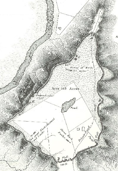
Black and white map of Spruce Hill in 1846
A drawing of Spruce Hill Earthworks taken from Ancient Monuments of the Mississippi Valley, c.1846.  Click this image for a larger version of the original Squier and Davis plate.

Squier & Davis

Hilltop Ceremonies

American Indians built dozens of monumental earthen mounds and enclosures in the Ohio River valley during the Hopewell episode between about 1600 and 2000 years ago. Most of these enclosures were built in river valley settings using a standard unit of measure in precise geometric forms of circles, squares, octagons, and long parallel lines. But at least a dozen hilltop enclosures were built in the hilly Appalachian Plateau province of south-central Ohio during the Hopewell episode. The earth and stone walls of these hilltop enclosures follow the irregular contours of prominent flat-topped hills. When non-Native colonists first encountered the hilltop enclosures in the 1800s, they thought they were seeing ancient fortifications: “The natural strength of such positions, and their susceptibility of defense, would certainly suggest them as the citadels of a people having hostile neighbors, or pressed by invaders” (Squier and Davis, 1848:9). But more recent archeological investigations instead suggest the hilltop enclosures were used as ceremonial centers, much like the geometric enclosures in the valley bottoms.

Spruce Hill is a prominent landform rising 400 feet above the valley of Paint Creek below. The west side provides grand vistas overlooking the valley bottom, where the geometric enclosures of the nearby Baum Earthworks and Seip Earthworks are found. The Spruce Hill enclosure is unusual: it is built of stone, whereas most enclosures are built of earth. The low stone wall runs just below the brow of the flat, mesa-like hilltop, enclosing almost 150 acres. Four gateways are located where ridge spurs afford points of easy ascent. The wall probably never resembled anything like a regularly laid up or mortared wall, and the casual visitor might well mistake the wall for a natural stone outcrop. This impression “is speedily corrected upon reaching the points where the supposed line of debris, rising upon the spurs, forms curved gateways, and then resumes its course as before” (Squier and Davis 1848:11). At several locations, the stones "exhibit the marks of intense heat, which has in some instances vitrified their surfaces, and fused them together" (Squier and Davis 1848:12). Recent investigations by NPS archeologist Bret Ruby suggest Squier and Davis were correct when they proposed that "perhaps the walls of stone were sustained or surmounted by wooden structures of some sort, the destruction of which, in whole or in part, by fire, caused the appearances noticed" (Squier and Davis 1848:12; see Ruby 2009).

Two other Hopewell hilltop enclosures in southern Ohio are managed by the Ohio History Connection and open to the public:

Fort Ancient Earthworks & Nature Preserve - Ohio History Connection

Fort Hill Earthworks & Nature Preserve - Ohio History Connection
 
A rocky trail surrounded by trees
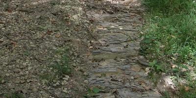
Exposed shale on the right side of the trail leading up to the plateau of Spruce Hill Earthworks.

NPS Photo / Tom Engberg

Geologic History

Spruce Hill is a small sliver of Ohio's geologic library, rich with a beautiful biodiversity, and laden with evidence of the prehistoric Hopewell culture. Even the trail that leads up to the storied plateau area contains geologic "windows" that allow us to see back in time. The sediment-washed trail has countless exposed layers of shale which date to almost 400 million years ago. Rippled sandstone, which dots the trail, is direct evidence that the area was once under the cover of a sprawling ancient sea. The lush woodland hillsides nurture rare and exotic flora and lively fauna of all shapes and sizes.

 
Arc of Appalachia logo

Present and Future

Spruce Hill Earthworks is owned by the Arc of Appalachia Preserve System. Please contact the Arc of Appalachia Preserve System for additional information or access to the site.
 
A colorful field of spring flowers in full bloom
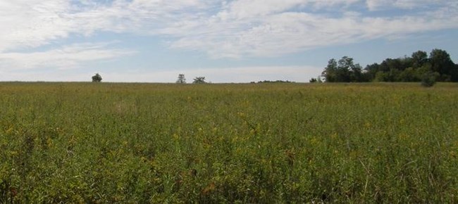
A sea of Goldenrod covers the plateau of Spruce Hill Earthworks in the spring.

NPS Photo / Tom Engberg

Resources and Readings

Arc of Appalachia

Fort Ancient Earthworks & Nature Preserve - Ohio History Connection

Fort Hill Earthworks & Nature Preserve - Ohio History Connection

Ruby, Bret J. (2009). Spruce Hill Earthworks: The 1995-1996 National Park Service Investigations. In Footprints - In the Footprints of Squier and Davis: Archaeological Fieldwork in Ross County, Ohio, edited by Mark J. Lynott, pp. 49-66. Special Report Number 5, National Park Service, Midwest Archeological Center, Lincoln, Nebraska. https://digitalcommons.unl.edu/cgi/viewcontent.cgi?article=1086&context=natlpark

Riordan, Robert V. (2019). At the Heart of Fort Ancient. In Encountering Hopewell in the Twenty-first Century: Ohio and Beyond (Volume 1: Monuments and Ceremony), edited by Brian G. Redmond, Bret J. Ruby, and Jarrod Burks, pp. 26–49. The University of Akron Press, Akron, Ohio. https://ideaexchange.uakron.edu/encountering_hopewell/2/

Squier, Ephraim G., and Edwin H. Davis (1848). Stone Work, Near Bourneville, Ross County, Ohio. In Ancient Monuments of the Mississippi Valley, pp. 11-14. Smithsonian Contributions to Knowledge, Volume 1. Smithsonian Institution, Washington, D.C. http://biodiversitylibrary.org/page/9042162

Thornberry-Ehrlich, Trista L. (2013). Hopewell Culture National Historical Park: geologic resources inventory report. Natural Resource Report NPS/NRSS/GRD/NRR— 2013/640. National Park Service, Fort Collins, Colorado. http://npshistory.com/publications/hocu/nrr-2013-640.pdf

Last updated: September 26, 2023

Park footer

Contact Info

Mailing Address:

16062 State Route 104
Chillicothe, OH 45601

Phone:

740 774-1125

Contact Us