
NPS/J. Tobiason
The
Teton Range towers over the valley of Jackson Hole, providing dramatic alpine
scenery and drawing millions of visitors to Grand Teton National Park each
year. Over billions of years, natural forces including earthquakes, glaciers
and erosion have shaped this magnificent landscape.
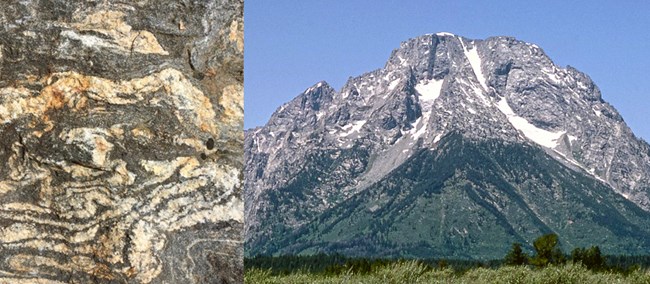
Left - NPS/P. Sasnett; Right - NPS Metamorphic & Igneous Rocks - Ancient Core A 2.7 billion-year old metamorphic rock called gneiss makes up much of the Teton Range. These rocks were formed when sea floor sediments and volcanic debris were buried up to 18 miles deep as two tectonic plates collided – similar to the collision of India and Asia today forming the Himalayas. The intense heat and pressure at these great depths changed or metamorphosed the sediments into today's rocks, separating different minerals into lighter and darker layers. Watch for the zebra-striped layers as you step over rocks on your hike.
Molten magma began squeezing into cracks in the gneiss 2.5 billion years ago, and it cooled and crystallized to form igneous granite. This speckled rock with its interlocking crystals is harder than gneiss forming the highest peaks in the central Teton Range – Grand Teton, Middle Teton, and Mount Owen. Other peaks, such as Teewinot and Mount Moran, show stripes of darker and lighter gray where the granite cross-cuts the gneiss.
Roughly 775 million years ago, the region stretched north to south, cracking the deeply buried gneiss and granite and forming a series of vertical, east-west trending cracks. Basaltic magma squirted into these cracks and cooled to form dikes of an igneous rock called diabase. One of these dikes that slices through the face of Mount Moran is 150 feet wide—if the exposed part of the dike melted, the magma would fill Jenny Lake three times over! Black diabase dikes are also visible from the Teton Park Road on the east face of the Middle Teton and the southeast flank of the Grand Teton.
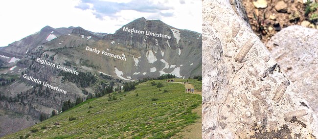
Left - NPS/S. Zenner; Right - NPS/E. Helton Sedimentary Rocks - Drape the CoreAbove the igneous and metamorphic core are layers of sedimentary rocks that wrap around the Teton Range and are eroding from the eastern side. For example, a small island of remnant sandstone tops the summit of Mount Moran! These sediments were laid down when global sea levels rose, first depositing beach sands (the Flathead Sandstone that caps Mount Moran) and continuing with limestones deposited in shallow seas and mudstones that were a deeper ocean floor. These seafloor rocks preserve a variety of fossils, including trilobites, stromatolites, corals, and shells of other organisms.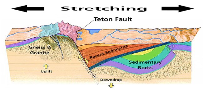
Reproduced with permission from Windows into the Earth by RB Smith & L. Siegel Mountain BuildingThe Tetons are one of the youngest mountain ranges in North America. They have been uplifting for less than 10 million years, making them "adolescent" mountains, as compared to the "middle-aged" Rockies (50-80 million years old) or the "elderly" Appalachians (more than 300 million years old). Erosion has had much less time to work in the Tetons, comparatively, so their jagged peaks remain standing high.
The Teton Range uplifts one earthquake at a time along the 40-mile long Teton fault, a north-south trending crack in the earth's crust. As the region stretches in an east-west direction, this stress builds to a breaking point and generates an earthquake, lifting the mountain block skyward while dropping the valley floor. On average, the fault moves about 10 feet in each earthquake: two to three feet up and four to six feet down. In the 10 million years since the fault began moving, the total offset is probably over 25,000 feet. As a quick estimate, the Flathead sandstone on top of Mount Moran is 6,000 feet above the valley and that same layer is buried roughly 20,000 feet below the valley floor on the east side of the fault.
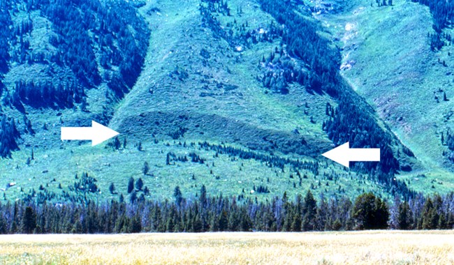
GRTE/Gilmore 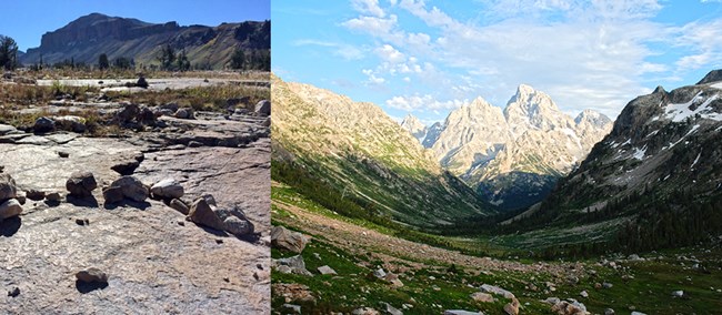
Right - North Fork Cascade Canyon - a classic U-shaped glacial canyon. Left - NPS/P. Sasnett; Right - NPS/D. Lehle Pleistocene Ice Age glaciers sculpted the Teton landscape over multiple glacial advances widening V-shaped river canyons into U-shaped glacial canyons, gouging out depressions filled by lakes today, sharpening high peaks, and filling the valley floor with outwash debris. The most recent advance, known as the Pinedale, lasted from roughly 50,000 to 12,000 years ago. Many hikers access the park's high country by traveling up glacial canyons such as Cascade, Paintbrush, Death Canyon and Granite. Look for features like glacially polished bedrock as you hike through these areas.
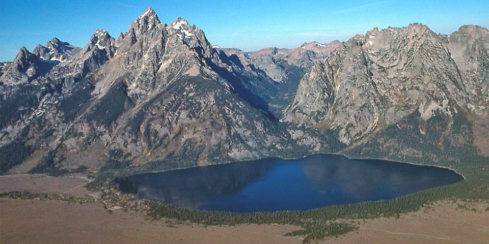
In an earlier glacial advance, about 200,000 years ago, large ice sheets flowed off the Yellowstone Plateau through the Jackson Hole valley, almost reaching Hoback Junction and burying the valley with more than 2,000 feet of ice. These glaciers left behind outwash plains of gravel and cobbles that are now covered in sagebrush. Glacial meltwater carried away the fine sands and silts that would have retained moisture and allowed topsoil to form; sagebrush is well adapted to dry soils, so it now covers these outwash plains. Conversely, conifers cover moraines, which mark the borders of former glaciers. Glaciers carry boulders, cobbles and gravel as they flow and grind up rocky material to the consistency of flour. As glaciers melt constantly at their terminus, they deposit this rocky debris as ridges called moraines. The fine-grained material help soils form and retains moisture, allowing trees to grow. Look for moraines ringing glacial lakes such as Jenny, Taggart and Jackson, as well as some isolated moraines such as Timbered Island.
NPS Other Park ResourcesTo learn more, visit Grand Teton's websites on glacial features and current glacier research. Watch four video podcasts: Geology Overview, Mount Moran, Teton Fault and Glaciers; and a geology animation to experience the forces that shaped this landscape. Outside ResourcesDiscover Grand Teton allows viewers to explore the geology of the region through a timeline, earthquakes, rocks and forces.
What's shaking in the Intermountain West (Montana, Idaho, Wyoming, Nevada, Utah, Colorado, Arizona and New Mexico)? The site provides local magnitude, times of occurrence and proximity to local towns and cities. |
Last updated: May 14, 2024
