Due to high fire danger throughout the park, a fire ban has been put into place. As a result, the lighting of campfires and charcoal grills is not allowed at this time. More
Rehabilitation began on December 9 for the 2.3-mile-long Cosby Entrance Road from TN State Route 32 to the gate of Cosby Campground. While crews are working, the entrance road is closed to the public. The work is projected to be completed in spring 2025. More
Kuwohi Rd (formerly Clingmans Dome Rd), Parson Branch Rd, Rich Mountain Rd, Little Greenbrier Rd to the schoolhouse, and Roaring Fork Motor Nature Trail are closed for the season. More
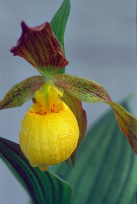
Yellow Lady's Slipper orchids can occasionally be found in the woods at low to mid elevations in the park.
The following hikes are especially good for viewing spring wildflowers. Download a park trail map to find the location of these trails or visit a visitor center.
Hikes
Oconaluftee River Trail
The Oconcaluftee River Trail is an easy, three mile roundtrip, riverside walk begins at Oconaluftee Visitor Center located two miles north of Cherokee, NC on US-441.
Deep Creek Trail
The Deep Creek waterfalls loop begins at the end of Deep Creek Road, 1⁄2 mile beyond the Deep Creek Campground turnoff. The Deep Creek area is located north of Bryson City.
Gregory Ridge Trail
The first two miles of the Gregory Ridge Trail offer good wildflower viewing. To get there, take Cades Cove Loop Road just past the Cable Mill area. Turn onto Forge Creek Road and follow it to the end.
Kanati Fork Trail
The Kanati Fork Trail climbs for three miles to intersect with the Thomas Divide Trail on Thomas Ridge. You don't need to hike the whole way to see good wildflowers. The first mile or two have the best displays, especially in early spring.
The Kanati Fork Trail begins about 1⁄8 mile north of the Kephart Prong footbridge on the Newfound Gap Road (US-441), eight miles north of Oconaluftee Visitor Center.
Schoolhouse Gap Trail
The Schoolhouse Gap Trail that gently climbs 2.2 miles from Laurel Creek Road to School House Gap. This route includes a wide array of spring and summer flowers, including some unusual species. The trailhead is 3.9 miles west of the Townsend "Y" on the road to Cades Cove. Be aware that this trail sees large crowds in the spring.
Little River Trail
The Little River Trail is a relatively wide and level footpath which follows the scenic Little River toward its headwaters. The trailhead is located on a side road which begins just before you enter Elkmont Campground.
The first two miles of the Little River Trail provide good wildflower viewing from mid-March through April. By adding the Cucumber Gap and Jakes Creek trails, you can make a pleasant 5.4 mile loop hike.
Middle Prong Trail
A walk on this old road will reward the hiker with flowers as well as views of Lynn Camp Prong Cascades. In the first two miles you may see foamflower, toothwort, violets, wood sorrel, and trilliums. The trail starts at the end of Tremont Road, which begins just west of the Townsend "Y."
Cove Hardwood Self-guiding Nature Trail
This 3⁄4 mile loop trail offers some of the best spring wildflower viewing in the park. It begins at Chimneys Picnic Area, 4.4 miles south of Sugarlands Visitor Center on the Newfound Gap Road (US-441).
Porters Creek Trail Porters Creek Trail often has spectacular wildflowers from late March through April. The trailhead is located in the Greenbrier area (follow highway US-321 about six miles east of Gatlinburg). The first 1.5 miles of trail offer good wildflower viewing.
Appalachian Trail
The two-mile section between Newfound Gap and Road Prong Trail has good flowers from mid-April through May. Park at Newfound Gap and use the cross-walk to cross the road to the trail sign, headed south.
Each spring, the park hosts the Spring Wildflower Pilgrimage, featuring programs, guided walks, and hikes that explore the wondrous diversity of life in the national park. Visit the pilgrimage website for additional information.