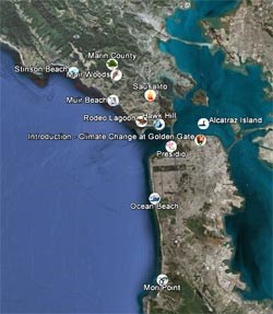
This multimedia tour shows how climate change may impact Golden Gate National Recreation Area. Each of eleven sites, indicated by map icons, focuses on specific threats through a combination of written summaries, photos, videos, GIS map layers you can turn on and off, and links to further information. To take this tour, you must first have Google Earth (free) installed on your computer. You may then download the Climate Change Tour (7 MB KMZ file) onto your computer, and then double click the tour file to run the tour in Google Earth. Alternatively, you may view the video version below. Click on the map icons or the tour items listed in the "Temporary Places" folder in the column to the left of the map. From there, you can explore the tour components by clicking on and off different sites and GIS layers. You may also click on the "GUIDED AUDIO TOUR" for a narated fly through version. Start your tour by selecting the Introduction icon (Park Service Arrowhead). The requested video is no longer available.
|
Last updated: February 28, 2015
