Have you ever tried to watch a tree grow? While we all know that trees do grow, measuring how much they grow can be a challenge. Imagine being asked to find out how much bigger or smaller, or taller or shorter, a tree becomes over the course of days, weeks, months, or years. How long might it take you to notice if a tree had changed in size? Such a study may sound as exciting as the old adage of "watching paint dry." However, by measuring the change in size of ponderosa pine and Douglas fir trees over time, ecologists working in Bandelier National Monument have gained valuable insights regarding both the inner workings of these trees and the fire histories of ponderosa pine forests in the Jemez Mountains.
The Dendroband
Thankfully, we don't have to go out, sit down in front of a tree, and watch it day after day to observe changes in tree growth. Instead, we have turned to a piece of equipment called a dendrometer band, or dendroband. An example of an installed dendroband is shown in Figure 1.
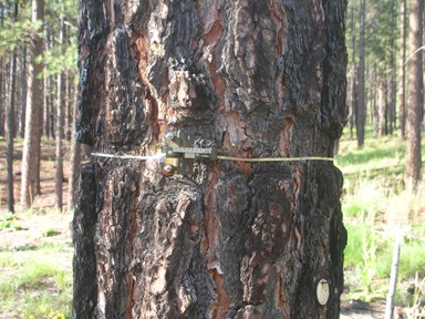
Figure 1. A ponderosa pine tree installed with a dendroband at the middle-elevation site.
Photo by Luke Gommermann.
A dendroband consists of two parts. First, a thin strap of metal, about the size of the colorful ribbons that adorn birthday presents, is wrapped once around the outside bark of a tree about 4-5 feet above the ground. Dendrobands are carefully installed to make sure it is level and not twisted around, or caught on, the bark of the tree. The ends of the metallic strap are then connected to a bimetal spring housed inside of a ruler which is secured onto the tree with bolts drilled into the wood.
As the tree expands or shrinks in circumference, the spring expands or contracts with it. We can visit the tree at any time, take a quick look at the ruler, and measure its current size down to the tenth of a millimeter! These measurements can be compared to measurements taken in the past to track how much the tree has grown or shrunk.
What We've Learned
Beginning in 1991, thirty ponderosa pine trees were selected from three forest types within Bandelier National Monument: a low-elevation (~6,600 feet) ponderosa pine, piñon pine, and juniper woodland, a middle-elevation (~7,600 feet) ponderosa pine forest, and a high-elevation (~9,100 feet) mixed conifer forest primarily composed of ponderosa pine, Douglas fir, and aspen (Figure 2). Since that time, measurements have been made early in the morning on a weekly basis from March through October and every 2-4 weeks from November through February. Occasionally, the dendrobands are adjusted to ensure reliable measurements. If a tree has died, the dendroband is removed and another tree at the same site is fitted with the band.
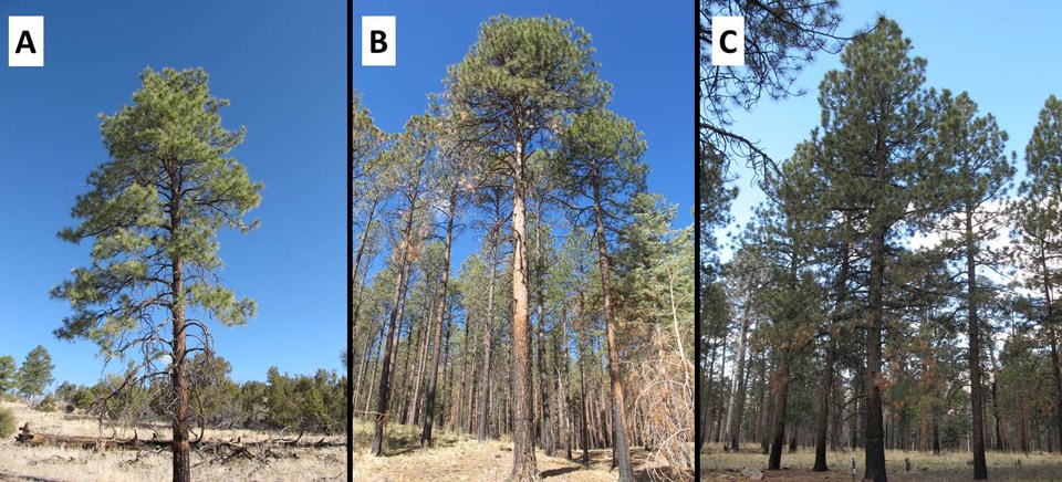 Figure 2. Photos of a ponderosa pine trees installed with a dendroband at the low-elevation site (A), middle-elevation site (B), and high-elevation site (C).
Photos by Luke Gommermann.
We have made several informative findings based on these measurements. First, ponderosa pine can both increase (swell) or decrease (shrink) in circumference over time, much like a sponge can change size as it is soaked in water, allowed to dry, and then soaked again. Figure 3 shows the change in size of trees at the low-elevation site during 1992. During the growing season, trees shrank during drier times but quickly swelled following precipitation.
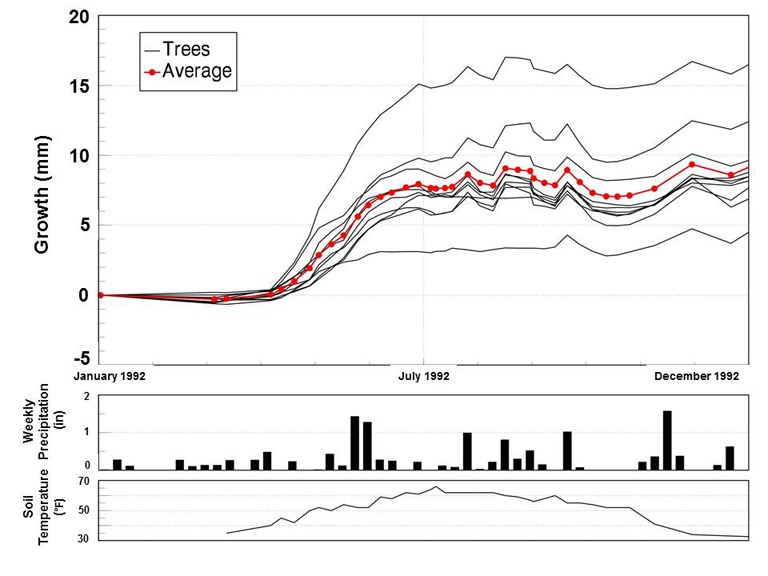 Figure 3. Weekly measurements of ponderosa pine size, precipitation, and soil temperature at the lowest elevation site during 1992.
Figure created by Kay Beeley.
Figure 3 also documents tree growth is greatest in the early growing season, occurring before the arrival of the summer monsoons. It would follow that the amount of winter snowfall has a large influence on tree growth during the following growing season. Data from dendrobanded trees can also be used to look at patterns over longer time periods. Figure 4 displays the average basal area index (BAI) of ponderosa pine trees at each of the three sites since 1992. The BAI is a measure of tree size. Based on graphs such as these, it is relatively easy to pick out years when water was plentiful based on large increases in growth across all sites (e.g., 1992-1995) or drought years when water was scarce and trees shrank or hardly changed (e.g., 2002-2003), resulting in the death of some banded ponderosa pine and most mature , piñon pine.
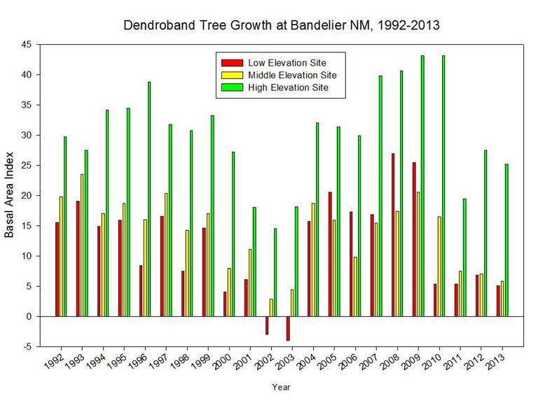 Figure 4. Average basal area index of ponderosa pine trees across a 2,500 foot elevation gradient within Bandelier National Monument from 1992 to 2013.
Figure created by Kay Beeley.
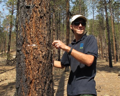
Figure 5. Student Conservation Association intern Luke Gommermann adjusts a dendroband around a ponderosa pine tree at the middle-elevation site.
Photo by Craig Allen.
We have learned that ponderosa pine trees at the highest elevation site consistently grow more each year than trees at the middle and lowest elevation sites, which grow at similar, slower rates. It is interesting to note that the mixed conifer forest at the high-elevation site appears to provide better growing conditions for ponderosa than the ponderosa pine forest at the middle-elevation site. This hints that ponderosa pine forests are not necessarily the best places for ponderosa pine to grow. Pure stands of ponderosa pine represent locations where ponderosa's tolerate the local environmental conditions better than all other tree species, and are therefore dominant. Where growing conditions for ponderosa are better, competition from other species, such as Douglas fir and aspen, limit ponderosa pine distribution.
Additionally, all trees studied at each site, regardless of age or species, begin growing in the spring at about the same time (within a week or two during most years). However, trees begin growing earlier in the year at lower elevations as it warms up sooner.
Lastly, we have been able to determine that trees tend to grow fastest during the early months of the growing season (i.e., April-July). Using this information in combination with fire scars found within the annual growth rings of trees across the Jemez Mountains landscape, strong evidence is revealed regarding the seasonality of historical forest fires. We can see that the vast majority (~95%) of historical forest fires occurred during the early growing season of ponderosa pine. This is important information for land owners of today's ponderosa pine forests within the Jemez Mountain landscape.
Future Questions
As this study continues into its 23rd growing season, future monitoring of the trees within Bandelier National Monument will provide essential information to better understand the influence of climate change in the Jemez Mountains landscape. In particular, we are interested in understanding the decline in tree growth leading up to tree's demise resulting from drought. A drought during the 1950s caused a dramatic die-off of ponderosa pine growing at the lower and dryer edge of their range within Bandelier National Monument. During the current, on-going drought, we have already witnessed ponderosa pine dieback at the lowest elevation site over the course of this study.
The fate of today's ponderosa pine trees remains unknown. However, as ecologists working at Bandelier National Monument continue the dendroband program, we will be better prepared to anticipate, and interpret, future landscape changes across the Jemez Mountain landscape.
