|
Biological ORVs
|
|
|
|
1. Numerous small meadows and riparian habitat with high biological integrity.
|
Segments 1 and 5 – Merced River Above Nevada Fall and South Fork Merced River Above Wawona
|
-
Meadow bare soil
-
Meadow fragmentation resulting from proliferation of informal trails
-
Streambank stability
|
|
2. The meadows and riparian communities of Yosemite Valley comprise one of the largest mid-elevation meadow-riparian complexes in the Sierra Nevada.
|
Segments 2A and 2B – Yosemite Valley
|
-
Meadow fragmentation resulting from proliferation of informal trails
-
Status of riparian habitat
-
Riparian bird abundance
|
|
3. Sierra sweet bay (Myrica hartwegii) is a rare plant found on river banks of the South Fork Merced River.
|
Segments 7 and 8 – Wawona and South Fork Merced River below Wawona
|
Population decline
|
|
Geologic/Hydrologic ORVs
|
|
|
|
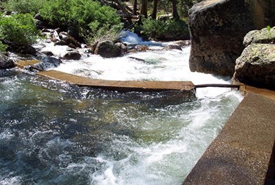
4. The upper Merced River canyon is a textbook example of a glacially-carved canyon.
|
Segment 1 – Merced River Above Nevada Fall
|
None; the ORV is impervious to human disturbance
|
|
5. The “Giant Staircase,” which includes Vernal and Nevada Falls, is one of the finest examples in the western United States of stair-step river morphology.
|
Segments 2A and 2B – Yosemite Valley
|
None; the ORV is impervious to human disturbance
|
|
6. The Merced River from Happy Isles to the west end of Yosemite Valley provides an outstanding example of a rare, mid-elevation alluvial river.
|
Segments 2A and 2B – Yosemite Valley
|
The California Rapid Assessment Method (CRAM)
|
|
7. The boulder bar in El Portal was created by changing river gradients, glacial history, and powerful floods. These elements have resulted in accumulation of extraordinarily large boulders, which are rare in such deposits.
|
Segment 4 – El Portal
|
None; the ORV is impervious to human disturbance
|
|
Cultural ORVs
|
|
|
|
8. Yosemite Valley American Indian ethnographic resources include a linked landscape of specifically mapped traditional-use plant populations as well as the ongoing traditional cultural practices that reflect the intricate continuing relationship between indigenous peoples of the Yosemite region and the Merced River in Yosemite Valley.
|
Segments 2A and 2B – Yosemite Valley
|
-
Meadow fragmentation due to the proliferation of informal trails
-
Status of riparian habitat
-
California black oak- number of adults and ratio of saplings to adults
|
|
9. The Yosemite Valley Archeological District is an unusually rich and linked landscape that contains dense concentrations of resources that represent thousands of years of human settlement.
|
Segments 2A and 2B – Yosemite Valley
|
Condition of Yosemite Valley Archeological District
|
|
10. The Yosemite Valley Historic District represents a linked landscape of river-related or river-dependent, rare, unique or exemplary contributing resources that bear witness to the historical significance of the river system.
|
Segments 2A and 2B – Yosemite Valley
|
FMSS Condition Assessments
|
|
11. The El Portal Archeological District contains dense concentrations of resources that represent thousands of years of occupation and evidence of continuous, far-reaching traffic and trade. This segment includes some of the oldest deposits in the region and the archeological remains of the Johnny Wilson Ranch, a regionally rare historic-era American Indian Homestead.
|
Segment 4 – El Portal
|
Condition of El Portal Archeological District
|
|
12. This segment includes regionally rare archeological features representing indigenous settlement and use along the South Fork Merced River at archeological sites with rock ring features.
|
Segment 5 – South Fork Merced River Above Wawona
|
Condition of archeological sites
|
|
13. The Wawona Archeological District encompasses numerous clusters of resources spanning thousands of years of occupation, including evidence of continuous far-reaching traffic and trade. Segment 7 includes the remains of the U.S. Army Cavalry Camp A.E. Wood documenting the unique Yosemite legacy of the African American Buffalo Soldiers and the strategic placement of their camp near the Merced River.
|
Segments 5, 6, 7, and 8 – South Fork Merced River Above Wawona, Wawona Impoundment, Wawona, South Fork Merced River Below Wawona
|
Condition of Wawona Archeological District
|
|
14. The Wawona Historic Resources ORV includes one of the few covered bridges in the region and the National Historic Landmark Wawona Hotel complex, which is one of the largest existing Victorian hotel complex in a national park and one of the few remaining in the United States with this high level of integrity.
|
Segments 5, 6, 7, and 8 – South Fork Merced River Above Wawona, Wawona Impoundment, Wawona, South Fork Merced River Below Wawona
|
Condition Assessment
|
|
Scenic ORVs
|
|
|
|
15. Visitors to this Wilderness segment experience exemplary views of serene montane lakes, pristine meadows, slickrock cascades, and High Sierra peaks.
|
Segment 1 – Merced River Above Nevada Fall
|
No indicator is proposed, as Wilderness designation precludes development
|
|
16. Visitors to Yosemite Valley experience views of some of the world’s most iconic scenery, with the river and meadows forming a placid foreground to towering cliffs and waterfalls.
|
Segments 2A and 2B – Yosemite Valley
|
Application of the Visual Resource Management System
|
|
17. The Merced River drops 2,000 feet over 14 miles, a continuous cascade under exemplary Sierra granite outcrops and domes.
|
Segment 3 – The Merced Gorge
|
Application of the Visual Resource Management System
|
|
18. The South Fork Merced River passes through a vast area of exemplary and wild scenic beauty.
|
Segments 5 and 8 – South Fork Merced River Above and Below Wawona
|
No indicator is proposed, as management as wilderness precludes development.
|
|
Recreational ORVs
|
|
|
|
19. Visitors to federally designated Wilderness in the corridor engage in a variety of river-related activities in an iconic High Sierra landscape, where opportunities for primitive and unconfined recreation, self-reliance, or solitude shape the experience.
|
Segment 1 – Merced River Above Nevada Fall
|
Wilderness Encounters
|
|
20. Visitors to Yosemite Valley enjoy a wide variety of river-related recreational activities in the Valley’s extraordinary setting along the Merced River.
|
Segments 2A and 2B – Yosemite Valley
|
Visitor Densities at Valley attractions, beaches or trails
|


