McGregor Mountain Trail

When man ventures into the wilderness, climbs the ridges, and sleeps in the forest, he comes in close communion with his Creator. When man pits himself against the mountain, he taps inner springs of his strength. He comes to know himself.
–William O. Douglas

 
Distance - one way Elevation gain Use Difficulty

7.7 miles (12.4 km) to the summit

6,600 ft (2,000 m)

Hiking and stock

Strenuous

 
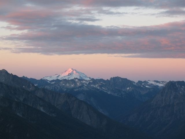
Glacier Peak from McGregor
Looking south from McGregor Mountain toward the Glacier Peak Wilderness

NPS

For those wanting expansive alpine views, the McGregor Mountain Trail provides a challenging adventure as it switchbacks steeply up McGregor Mountain. At 7,000 feet (2,134 m), this is the second-highest established camp in the park, and the highest accessible to stock riders. This trail can be done as a day hike from Stehekin by taking the shuttle bus to the base of the trail, or backpackers can add this as an intriguing side trip to a longer backpack from numerous directions. See the detailed trail description for more information.

Special Concerns:

  • Carry plenty of water, this is a hot, dry trail with little access to water along the way
  • This is a steep trail that requires an ice axe when snow-covered.
  • Reaching the summit requires route-finding and exposed scrambling over talus and rock, and should only be attempted by those with the skills and experience to undertake this climb.
  • Pets and hunting are not allowed.

Backcountry Camping: A backcountry permit is required for all overnight stays. Located at 7,000 feet (2,134 m) near the end of the trail, Heaton Camp is a single-party site for up to 12 persons or stock. A nice base camp can also be had in the valley at High Bridge or Tumwater camps.

Access: From Stehekin, take the shuttle bus 11 miles to its end at High Bridge and follow the Old Wagon (Pacific Crest) Trail heading north toward Howard Lake. Backpackers can reach this trail from the north via the Bridge Creek Trail or from the west via the Cascade Pass and Upper Stehekin Valley (old road) trails.
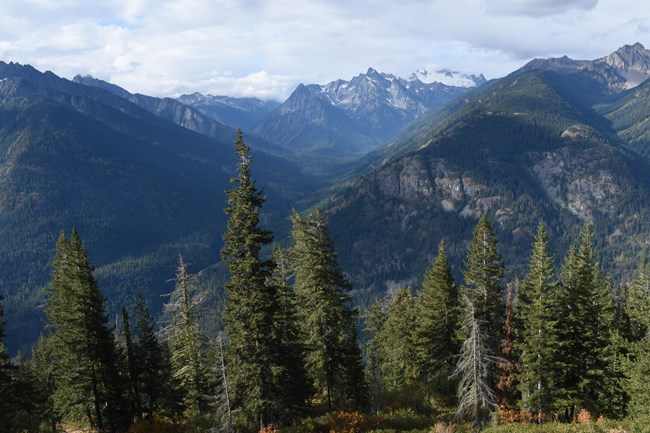
 
A view from 2,00 feet up looking down into a forested mountain valley, with craggy, glacier-covered peaks in the distance.
The McGregor Mountain Trail begins in humble forest and cllimbs to lofty heights. View from around 3,600 ft in elevation.

Detailed Trail Description

The trail (it is the Pacific Crest Trail north at this point) begins behind the corral at High Bridge, and climbs moderately to Howard Lake in 1.3 miles (2.1 km). Enjoy the birding and other attractions of this little lake before heading on. The signed junction to McGregor Mountain Trail is just beyond the lake, on the right.

The hike is mostly forested in the beginning, with rocky outcrops offering occasional views. As you continue upward, the forest eventually begins to thin, giving way to talus slopes and better views. Listen for the high pitched squeak of the pika which makes its home in the subalpine zone. The trail switchbacks relentlessly. A good viewpoint lies approximately 2.9 miles (4.7 km) and a 2,100 foot climb (640 m) up on the trail from High Bridge, providing a great day-hiking destination.

Seven miles (11.3 km) up the trail, Heaton Camp lies in a subalpine forest at 7,000 feet (2,134 m). Hikers who have toiled to this elevation will be delighted with a bird's eye view of the Stehekin River Valley and fantastic views of the surrounding peaks, with all of the Glacier Peak Wilderness rising to the south. Backpackers will reap an additional reward of a high camp from which to watch the sun sink to the west. Water is usually available a short distance along the trail below the camp, from a small stream fed by seasonal snowmelt.

Climbers and experienced hikers who want further adventure can continue upward with care. From Heaton Camp the trail continues for a short distance for continued great views, then the trail ends at an enormous talus slope. The summit looms 1,000 feet (330 m) above. Reaching the summit requires a hand-and-foot scramble up the talus slope and along exposed rocky ledges. Route-finding skills are essential. The most used route starts at the top of the talus field to the left of the summit. Look for faint, intermittent red arrows painted on the rocks marking the best way to proceed. A radio repeater is visible on the summit, providing a good landmark for those attempting to negotiate the summit route.

The summit was the site of an old fire lookout until 1955. From the summit there is an stellar panorama of the entire Stehekin Valley and the surrounding mountains, including Glacier Peak. On the north-facing slope below the summit lies the Sandalee Glacier. With over 750 glaciers, the North Cascades are the most heavily glaciated mountains in the U.S. outside of Alaska. Sandalee is one of four glaciers currently being monitored annually by the National Park Service in North Cascades National Park.

 
Wilderness logo of wolf howling at moon.
Ninety-three percent of North Cascades National Park Service Complex is designated as the Stephen Mather Wilderness, set aside by law for "the American people of present and future generations" for our protection and enjoyment. Please follow all Leave No Trace hiking and camping practices to reduce your impact on this special place and leave it unimpaired for future generations.
 
A multi-cragged mountain of gray rock rises from a talus field. A yellow line marks a possible route up.
For hikers looking to summit McGregor Mountain, climb the talus field and find a route marked with faint, pink arrow. Note that this is not a maintained route and it is a difficult, exposed scramble. Conditions change year-to-year and snow can linger into August. Graphic is not a route map; for reference only.

NPS Graphic

Last updated: October 20, 2022

Park footer

Contact Info

Mailing Address:

810 State Route 20
Sedro-Woolley, WA 98284

Phone:

360 854-7200

Contact Us