|
The care of rivers is not a question of rivers, but of the human heart. -Tanaka Shozo, Japanese conservationist

Sage Boerke This trail makes an excellent day hike into a deep, wild North Cascades valley for anyone camping in the upper Special Concerns:
Backcountry Camping: Access: 
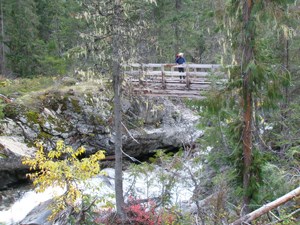
NPS/Rosemary Seifried Detailed Trail Description The trail almost immediately crosses a bridge over the Stehekin River, which roars through a narrow bedrock gorge below your feet. The bridge is a great spot to watch for the American Dipper, or Water Ouzel, which has been sighted diving into the cascading river here in search of food. On the south side of the bridge a sign post indicates the access trail to the Flat Creek Camp, which was closed due to hazard trees. Observant travelers will note that for miles upstream and downstream of this brief gorge the bed of the Stehekin River is wider and meanders through floodplain deposits. The exposed bedrock below the bridge is a sign of the geologic forces that converged in this area. During past ice ages, glaciers descending the Stehekin valley and the Flat Creek valley converged and exposed this bedrock outcrop. Since the glaciers receded, the Stehekin River has vigorously cut into the rock, thus allowing itself to be "captured" in a narrow channel. The first couple miles of the trail burned in the 2001 Flat Creek Fire, and representatives of all woodpecker species native to western Washington have been seen among the standing dead trees in the old burn. Purple flower spikes of fireweed punctuate the forest floor, and views abound as the trail gently ascends the valley. Peak 6062' presents an impressive profile rising like the prow of a ship from the wide valley floor. For the first 3.2 miles (5.1 km) the trail traverses ~100 feet (30 m) above the valley bottom and provides views down to lush, wide riparian meadows punctuated with old-growth cottonwoods several feet in diameter. After the first 2 miles (3.2 km) the proximate vegetation begins to dominate the trail views, and the trail leaves North Cascades National Park. As the trail nears the West Fork Flat Creek at 3.3 miles (5.3 km) it passes through a stand of old-growth western red cedars that provides an excellent place for a rest. The trail continues on the other side of the creek, which must be forded (may not be possible during spring snow melt when the water runs high). Beyond the West Fork the trail wanders through a wide forested floodplain of old-growth and some of the western red cedars reach diameters of 6 feet (1.8m) or more. As the trail continues the valley becomes narrower, the trail enters the brushy riparian zone near the creek, and eventually peters out in a stand of cedars. 
|
Last updated: August 3, 2024
