|
Climate change creates ripple effects throughout the environment of Mount Rainier and the Pacific Northwest. Park scientists are studying the effects of climate change in a variety of areas in the park.

Excerpt from Puyallup Watershed Thermal Imagery Web Map, created by Brian Zierdt, South Puget Sound Salmon Enhancement Group. Water Temperatures & FishMount Rainier National Park is home to a variety of native and non-native fish. But the fish that makes Mount Rainier special, and that gets most of the attention, is the bull trout (Salvelinus confluentus). Bull trout are a federally listed threatened species that require cold, complex, and connected habitats. There are over 30 miles of designated critical habitat for bull trout within the park. The reason for this is that Mount Rainier is the most heavily glaciated peak in the contiguous United States, and as such provides excellent cold-water habitat for bull trout. However, as glaciers and snow levels rapidly decline in a changing climate, rivers on Mount Rainier may see higher water temperatures. 
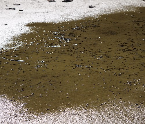
NPS Photo Aquatic Habitats & AmphibiansAmphibians depend on water for breeding and aquatic habitats are drying up earlier in the summer. Generally warmer, drier conditions can cause moist microhabitats, such as ephemeral ponds and intermittent flowing streams, to become too dry and unsuitable for native amphibians. Western Toads, a terrestrial species, migrate to breed and lay their eggs in subalpine lakes, which are being affected by climate change. On Mount Rainier, this egg deposition is timed with the spring snowmelt. Many of the breeding ponds and pools of water that toads rely on are drying up earlier in the season, resulting in mass mortalities of eggs, larvae (tadpoles), and metamorphs such as toadlets. A shift to earlier breeding may leave amphibians exposed to fluctuating weather conditions, such as cold storms in spring. Other amphibian species of concern include Van Dyke’s salamander and larch mountain salamander. Debris Flows & FloodingAs glaciers retreat, they deposit massive amounts of rocky debris into river systems. This debris fills up river channels when the rivers can’t support the amount of sediment flowing in the water, a process known as aggradation. The river water is forced to change direction and create new channels. This is why Mount Rainier’s rivers have wide, rocky, braided riverbeds. Climate change is accelerating glacial recession and thus increasing the sediment available to rivers to transport downstream. This can lead to new river channels in adjacent floodplains that are in the path of buildings and roads. In addition to melting glaciers, climate change is increasing rain and flooding events. Warmer temperatures means that precipitation falls as rain instead of snow. This can result in rapid aggradation and debris flows. 
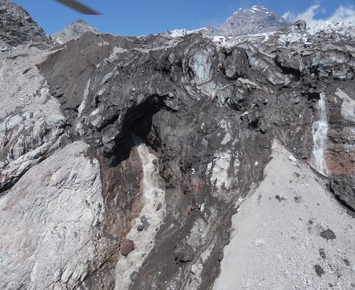
NPS Photo Hotter weather in the summer can also cause melting glacier water to build up quickly, and if it gets trapped in the ice, it could release suddenly in the form of outburst flooding, another cause of debris flows. Glacial outburst floods are the primary cause of glacially-originated debris flows in the park. Mount Rainier scientists are studying glaciers and river systems to better understand these dynamic forces and have developed a debris flow hazard system to determine conditions when debris flows may occur. Flooding & FishAnother side effect of an increase in extreme peak flows and flood events, is that they can scour redds (a spawning location on a riverbed) while fish eggs are incubating, damaging fish populations. Park scientists are conducting annual spawning surveys to track trends over time and location of spawning habitat. The park is also prioritizing the replacement of culverts throughout the park, including the White River Campground culverts as outlined in the Fish Management Plan. Culverts help combat high flows and removal of fish barriers. 
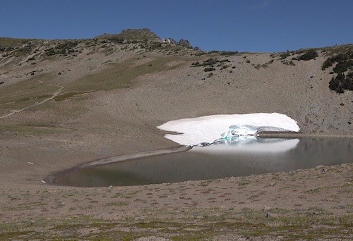
NPS Photo Water SupplyThe loss of perennial snowfields during the past thirty years, combined with the potential for lower annual snowpack and increased air temperatures, is decreasing water supplies. Mount Rainier National Park’s water supply primarily depends on streams and lakes fed by snowmelt and perennial snowfields. For example, the water at Sunrise comes from Frozen Lake, entirely fed by snowmelt. Warming temperatures correspond with shifts from solid to liquid precipitation (more rain, less snow) resulting in earlier snowmelt. This means there is less water later in the summer. Park visitation is increasing, putting more pressure on the limited park water supplies.
Please do your part when visiting by conserving water! Additional Research
Mount Rainier Climate Change:Climate Change Homepage |
Last updated: May 30, 2025
