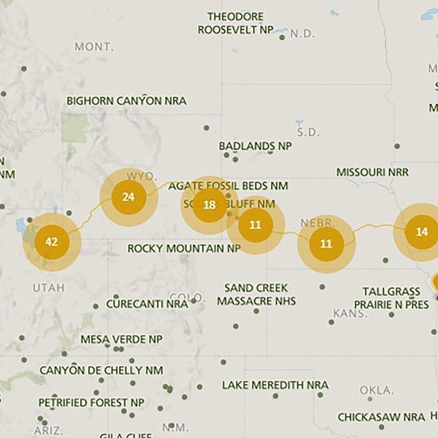
The Mormon Pioneer National Historic Trail was designated to preserve the story and routes of this nationally significant trail and to support the associated sites that preserve its history.
Learn more about sites that tell the story of the Mormon Pioneer Trail by visiting our state-by-state listing or take a look at a few highlighted places.
Sites:California National Historic Trail, Mormon Pioneer National Historic Trail, Oregon National Historic Trail, Pony Express National Historic Trail
The Mormon Handcart Historic Site & Visitor Center, operated by The Church of Jesus Christ of Latter-day Saints, is open to the public. Handcarts were not used by the initial 1847 Mormon expedition led by Brigham Young, but, rather, came later in the Trail's history. Thousands of emigrants on the Oregon and California trails shared the path with these handcarts.
Sites:California National Historic Trail, Mormon Pioneer National Historic Trail, Pony Express National Historic Trail
Hogsback Summit is where the Mormon Pioneer/California/Pony Express trail corridor crosses a low divide between the Weber River (present-day Henefer, Utah) and Dixie Hollow. The first wagons, belonging to the Donner-Reed Party, crossed this divide in 1846, followed in 1847 by Brigham Young's vanguard party of Mormon pioneers.
Sites:California National Historic Trail, Fort Laramie National Historic Site, Mormon Pioneer National Historic Trail, Oregon National Historic Trail, Pony Express National Historic Trail
North Platte River Crossing was one of numerous crossings used by trappers, traders, American Indians, and emigrants to reach Fort Laramie. In order to enter the fort, two rivers had to be crossed- the Laramie River and the North Platte River. Over the years, at least nine different sites were used to cross the Laramie and at least four different sites were used to cross the North Platte.
Sites:California National Historic Trail, Mormon Pioneer National Historic Trail, Oregon National Historic Trail, Pony Express National Historic Trail
Independence Rock was the most-noted landmark of the wagon trails west of Fort Laramie. The rock derived its name from a party of fur trappers who camped and celebrated Independence Day near the rock on July 4, 1830. Eventually, thousands of emigrants camped at the foot of this 1,900 feet long by 850 feet wide granite outcrop. They carved their names and messages into the granite, using Independence Rock as a bulletin board for Oregon Trail.
Sites:Mormon Pioneer National Historic Trail, Pony Express National Historic Trail
In 1859, Louis Guinard built a trading post and a bridge near the point where the Mormon Pioneer Company crossed the North Platte River in 1847. The Pony Express also established a station at this complex. Pony riders crossed the North Platte River on Guinard's Bridge, but the route stayed close to the north bank of the river until reaching Red Buttes Crossing, where another Pony Express station was located.