Filter Your Results
- Lewis & Clark National Historic Trail (506)
- Yellowstone National Park (277)
- New River Gorge National Park & Preserve (168)
- Mount Rainier National Park (136)
- Grand Canyon National Park (130)
- Cuyahoga Valley National Park (113)
- Oregon National Historic Trail (100)
- Cane River Creole National Historical Park (87)
- Dinosaur National Monument (82)
- Show More ...
- Geologic Resources Division (69)
- National Heritage Areas Program (64)
- Inventory and Monitoring Division (38)
- Rivers, Trails, and Conservation Assistance Program (38)
- Wild and Scenic Rivers Program (30)
- Eastern Rivers and Mountains Inventory & Monitoring Network (29)
- Natural Resource Stewardship and Science Directorate (29)
- Wildland Fire Program (29)
- National Register of Historic Places Program (26)
- Show More ...
Showing 5,310 results for Carbon River ...
Great Smoky Mountains National Park
Appalachian Clubhouse
- Type: Place
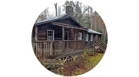
A large restored clubhouse rebuilt in 1934 and now available for daytime rental.
Katmai National Park & Preserve
Pelagia Melgenak
- Type: Person
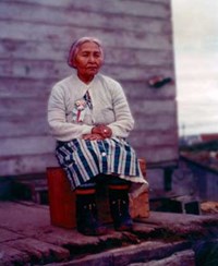
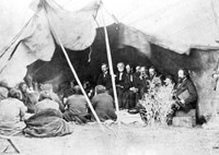
To learn the story of Pelagia (also spelled Palakia) Melgenak is to learn the sanctity of shared traditions, the loving bonds of kinship and the reverence of a spiritual connection to the land around you. Born in the late 1870s in the remote village of Savonoski in Alaska, Pelagia grew up learning about hunting, gathering, navigating and guiding in the area. That all changed in 1912 with the hot ash falling like a blanket covering the region with the eruption of Novarupta.
Mary McLeod Bethune Council House National Historic Site
Unita Zelma Blackwell (1933-2019)
- Type: Person

Born to sharecroppers in the Mississippi Delta, Blackwell rose from humble beginnings to become one of many unsung Black female heroines of the modern Civil Rights Movement. Blackwell was an outspoken critic of racial and economic inequality and the first Black female mayor elected in the state of Mississippi. We honor her as an ancestor for reminding us of the power to change the circumstances we were born into.
- Type: Person

There are people who give great speeches, and they there are those who perform them. Hallie Quinn Brown was one of the few who perform speeches. In her era, she was recognized as one of the greatest elocutionists across two continents, Europe and America. Though she rarely appears in history books, Brown’s legacy can be found in today’s speech-language pathologists and spoken word artists. She lectured widely on the cause of temperance, women’s suffrage, and civil rights. We
- Type: Article

Newsletter highlighting the activities of the Southeast Coast Inventory and Monitoring Network
- Type: Place
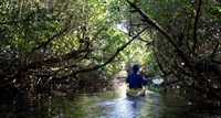
The Halfway Creek and Loop Trails are accessible from the Gulf Coast Visitor Center in Everglades City or from the Big Cypress Welcome Center on Sea Grape Drive off of US 41. The Creek is 7.3 miles long from the Big Cypress Welcome Center to the Gulf Coast Visitor Center. The upper loop is an additional 3.7 miles. From the Gulf Coast Visitor Center, the Halfway Creek-Left Hand Turner-Turner River loop is 11 miles. Allow 4-8 hours for these trails.
Grand Canyon National Park
South Kaibab Trail
- Type: Place

This well-maintained dirt trail offering wonderful expansive views. This is a great trail for short day hiking trips into the canyon of half a day or less. During winter months foot traction and hiking poles are advised when trail surfaces are icy. There is no public parking at the South Kaibab Trailhead. Please park at the Visitor Center, then take the Kaibab (Orange) Route shuttle bus to the trailhead. It is a 9-minute ride from the Visitor Center to the Trailhead.
Grand Canyon National Park
Bright Angel Trail
- Type: Place

Bright Angel Trail lets hikers walk in the footsteps of the canyon's Indigenous Peoples, miners, and early tourists, as they descend into the canyon's depths. Offering big views, morning and afternoon shade, resthouses, vault toilets, and water stations during the summer. The water is OFF at 1.5- and 3-mile resthouses. Portions of Bright Angel Trail are closed for waterline construction, Visit the link for a list of trail closures.
Grand Canyon National Park
Bright Angel Trailhead
- Type: Place
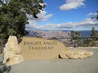
Bright Angel Trailhead is located just west of Bright Angel Lodge, Lookout Studio, and Kolb Studio. At 6,840 feet (2,085 m), it provides access for hikers and mules to many inner canyon destinations. From the Hermit Road Interchange shuttle bus stops, it is a short walk to the east, and up a hill, on a paved footpath to the trailhead. This winter, a number of trail closures (on parts of Bright Angel Trail) are in effect. Click on the link for details.
- Type: Place
Big Thicket National Preserve
Birdwatchers Trail
- Type: Place
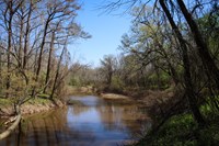
¾ mile roundtrip | This short hike leads to views of Menard Creek and the Trinity River, an important migration route for birds.
Great Smoky Mountains National Park
Meigs Falls
- Type: Place
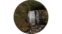
Admire a gorgeous waterfall from the comfort of your vehicle. Located along Little River Road, Meigs Falls features a spacious pull-out area for easy viewing. This makes it one of the most accessible waterfalls in the park.
- Type: Article

Northern Colorado Plateau Network’s scientists use satellite observations of vegetation condition in Curecanti National Recreation Area with climate data over time to reveal how climate influences plant production and phenology. Knowing which of the wide range of 16 vegetation assemblages found in Curecanti are more or less sensitive to climate change can help managers understand what to expect over the next few decades, and plan for the changes coming their way.
- Type: Article

The Inventory and Monitoring Division explored the effects of the Cameron Peak and East Troublesome Fires on trout, their habitat, and their food sources in Rocky Mountain National Park. The results show that high-elevation trout are resilient, providing valuable insight for park managers making conservation decisions.
Glacier National Park
St. Mary Falls Trail
- Type: Place

Sleeping Bear Dunes National Lakeshore
Katie Shepard Hotel
- Type: Place
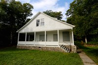
This large, one-and-a-half-story, shingle-style house was constructed in 1895 or 1896 for Mrs. William Shepard and her daughter Katherine, who was popularly known on the island as "Miss Katie." The house was allegedly designed in the style of the Shepards' residence in New Orleans. A detached kitchen and dining room was located behind the house. After the Cottage Row dining room closed around 1900, Katie Shepard converted her cottage into a summer hotel.
War In The Pacific National Historical Park
Fonte Plateau
- Type: Place

Fonte Plateau was a strategic location during the Battle of Guam. Home to a fortified Japanese naval communications base, the battle for control over Fonte Plateau was costly and pivotal. After days of fighting, US troops gained control of the position—forcing the Japanese Army's retreat.
- Type: Place
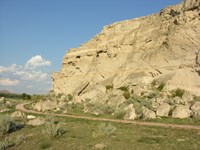
Following a day's journey from Fort Laramie, emigrants spent the night at Register Cliff , which rises one hundred feet above the North Platte River valley. The soft, chalky limestone rock made it easy for emigrants to inscribe their names into the cliff before continuing on their journey. The earliest signatures date to the late 1820s when trappers and fur traders passed through the area.
- Type: Place
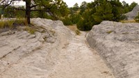
Oregon Trail Ruts State Historic Site , also called the Guernsey Ruts, is located where the geography of the area forced the Oregon Trail to change course. At this point, the Trail was blocked from continuing along the North Platte River by a steep ridge of sandstone rock. It had to go up and over the ridge in order to continue heading west.
- Type: Article

Guernsey, Wyoming, is situated along the North Platte River and the “Great Platte River Road”, a significant historic route followed by travelers on the Oregon, California, Pony Express, and Mormon Pioneer national historic trails. The small town is located along US 26, about 100 miles north of Cheyenne, Wyoming, and 66 miles west of Scottsbluff, Nebraska. Learn more about this area's rich history!